Interim Improvements: SR 347, I-10 to Northern Maricopa Limits 2023 Road Safety Assessment
Interim Improvements: SR 347, I-10 to Northern Maricopa Limits 2023 Road Safety Assessment
Contents
Background
As the primary route from the city of Maricopa to the Phoenix area, State Route 347 (SR 347) has become a highly traveled corridor. In spring 2023, ADOT completed a safety study on SR 347 between I-10 and the northern city limits of Maricopa. The Road Safety Assessment (RSA) identified potential safety issues related to roadway traffic and evaluated possible ways to improve safety for drivers.
As a result of this assessment, the following were implemented as interim measures to improve traffic conditions until more long-term improvements can be made.
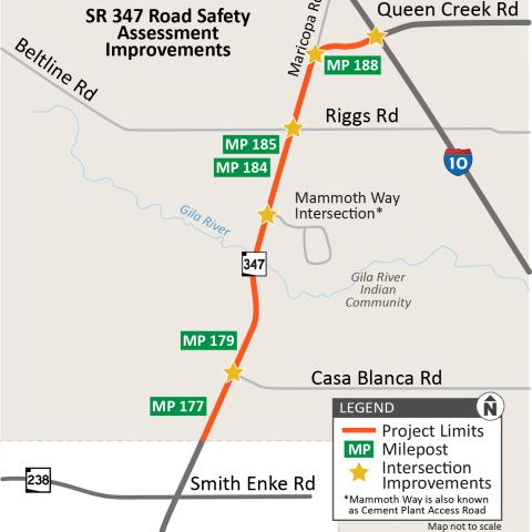
Project Map
Project Fact Sheet:
STRIPING IMPROVEMENTS
What: Restriping in the following areas to add or extend turn lanes: Queen Creek Road/Interstate 10 interchange; Riggs Road intersection; Casa Blanca Road intersection; Old Maricopa Road intersection; and the Mammoth Way intersection.
Why: Restriping allowed for more vehicles to queue in the turn lanes and potentially alleviate some of the congestion and back-ups at these intersections.
When: These changes were implemented in October 2023.
Photos of Striping Work at SR 347 intersections:
Mammoth Way (Cement Plant Access Road)
SR 347 (Queen Creek Road) and I-10 interchange
SIGNAGE AND SIGNAL IMPROVEMENTS
What: New traffic signs added or replaced at intersections. An additional signal pole was installed at the eastbound I-10/Queen Creek off-ramp. Traffic signal timing was adjusted, and is being monitored and adjusted as needed going forward. Reflective signal head backplates were also installed.
Why: The new signs and existing sign changes provide additional guidance for lane usage and improve both driver awareness and line of sight at intersections. The new signal pole (I-10/Queen Creek Road) is an additional signal head that will improve the signal timing and better manage the traffic coming off the freeway. The signal timing adjustments help to alleviate unnecessary stopping of traffic at certain intersections. The reflective backplates on signals improve visibility in both daylight and darkness.
When: The reflective backplates were installed in October 2023. The new signal pole at the eastbound I-10 ramp at Queen Creek Road was installed in late February 2024.
Emergency Signal Ahead Beacons:
The implementation of flashing ‘Signal Ahead’ warning beacons at certain intersections was completed. These devices are intended to reinforce awareness of existing traffic signals and can be placed in advance of signalized intersections where the intersection is hidden from the view of approaching travelers.
MEDIAN CROSSOVERS
What: Four existing median crossovers were refreshed to allow access for emergency vehicle use. One additional median crossover was created for an additional access point in the corridor. These locations are: milepost (MP) 177.81, MP 179.22, MP 184.24 and MP 188.62; and the new crossover at MP 185.77.
Why: These improvements allow for better access for first responders throughout the corridor in the event of an accident.
When: The work for the median crossovers was completed in January 2024.
SPEED ADJUSTMENT
What: Removal of signs that previously reduced the speed limit from 65 mph to 55 mph approaching intersections.
Why: This change is intended to increase compliance, reduce differential speeds, reduce the need for lane changing and potentially reduce rear-end crashes.
When: New signs were installed in October 2023.
Read the full RSA report
Read the Speed Study Summary