Overview
ADOT has reopened the 5-mile unpaved section of State Route 88 (Apache Trail) from Fish Creek Vista (milepost 222) to milepost 227 near Reavis Trailhead Road that was closed due to extensive roadway damage and rock debris following severe flooding in 2019.
The Woodbury Fire in June 2019 consumed almost 124,000 acres of the Tonto National Forest. In September 2019, a storm dumped approximately six inches of rain onto the fire scar and the runoff severely damaged large portions of the road, with the most damage being in the area between the Fish Creek Vista and milepost 227 (near Reavis Trailhead Road). The damage included a large rockslide that left that section of the road unpassable.

UPDATE
ADOT completed the interim project to reopen State Route 88 (Apache Trail) from Fish Creek Vista (milepost 222) to milepost 227 near Reavis Trailhead Road in September 2024.
ADOT invested $4 million for the interim project to restore limited access to five miles of SR 88 damaged by flooding in 2019, as it seeks funding for more extensive improvements needed to make the roadway more resilient and accessible long-term. The project removed boulders on Fish Creek Hill, mitigated rockfall between Fish Creek Vista and Fish Creek Bridge (mileposts 222-223.5), made repairs to retaining walls, installed new signage, cleaned and replaced damaged drainage culverts. This interim plan was presented to the State Transportation Board at its Jan. 12, 2024 meeting.
Although the 1.5-mile section at Fish Creek Vista is steep and more winding and narrow than other parts of SR 88, there are no vehicle restrictions in place now at Fish Creek Vista; however, this can change should severe weather or rockfall affect conditions. We recommend that drivers check the weather forecast before traveling, be confident in their vehicles and be comfortable negotiating a steep, winding and narrow section of unpaved roadway such as that found on SR 88 at Fish Creek Vista.
Maintenance crews worked on preliminary items ahead of the construction project like removing vegetation, filling in eroded areas in the road surface and cleaning out culverts. Contracted construction work began this summer. The U.S. Forest Service reviewed and approved the interim project design, since SR 88 follows an easement through federal land. In addition, the project was designed to meet all applicable state and federal environmental requirements.
2023 Study
In October 2023 ADOT completed a study, which recommended $33.7 million in improvements to make SR 88 more accessible and resilient to severe weather. Those improvements, developed with extensive public involvement and identified in a Design Concept Report, include:
- Chip sealing, in which aggregate is compacted into heated asphalt liquid to create a more durable road surface, throughout the 5 miles.
- Widening the roadway to 15 feet in steeper areas.
- Increasing drainage capacity to accommodate heavier rainfall.
- Rehabilitating or repairing existing bridges.
- Adding pullouts and other safety enhancements.
This longer-term plan does not have dedicated funding, and ADOT is pursuing federal funding to advance these longer-term improvements.
PDFs related to this study are available upon request. Please contact the Community Relations Project Manager to request a copy.
Background
State Route 88/Apache Trail was constructed in 1904 to provide construction access for the Roosevelt Dam, which was completed in 1911. Much of the route, particularly east of Tortilla Flat, retains its original historic character.
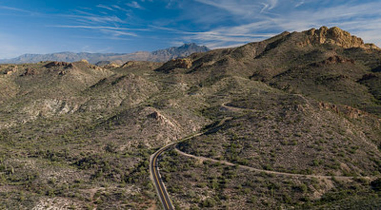
Aerial overview of SR 88.
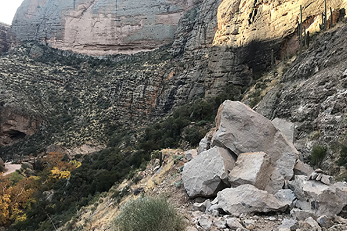
Damage to SR 88 caused by the Woodbury Fire.
For More Information

Subscribe to receive project updates and traffic alerts by email. For more information, please call the ADOT Bilingual Project Information Line at 855.712.8530 or submit a question or comment by email to [email protected].
For real-time highway conditions statewide, visit ADOT’s Traveler Information Site at www.az511.gov, follow ADOT on Twitter (@ArizonaDOT) or call 511, except while driving.
