Arizona's notable transportation history is subject of new report
Arizona's notable transportation history is subject of new report
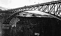
The Navajo Bridge, which opened in 1929 and spans the Colorado River, is just part of Arizona's transportation history.
Yesterday we kicked-off Arizona’s Centennial celebration with a look at where Arizona is today and how the work we do in the present will affect the lives of Arizonans in the future.
But we also promised that during the year ahead we’d dedicate our fair share of attention to celebrating Arizona’s past. And rest assured, history buffs, we do not plan to disappoint!
To prove it, we’re kicking off our retrospective by introducing a new report from the ADOT Research Center, Arizona’s Transportation History -- a 179-page publication that divides the timeline of our highway system into several distinct periods, dating all the way back to the 1400s.
“The biggest accomplishments in Arizona's highway history – the ones that really changed how Arizonans live – came early in the last century, when Arizona's highway engineers built the state's first modern, all-weather roads,” said Dr. Mark Pry, one of the researchers and authors of the report. Fred Andersen also researched and authored the report.
“Today we can barely comprehend how difficult travel once was for Arizonans,” said Pry. “Roads were rough or muddy, and sometimes they were simply impassable. There were no road signs, and often the shortest trips required long journeys over a maze of local roads. As a result, anyone who traveled from town to town faced a lot of uncertainty. You never knew exactly when you would arrive at your destination (or even if you would arrive) or what your mood and condition would be once you got there.”
The Beginning of Transportation in Arizona
Arizona's first real roads were mostly unmarked trails established by the Native Americans across the deserts, grasslands and mountains of our state. Members of the Hohokam and Hopi tribes, for example, routinely made long trips across Arizona and into other states for trading and for spiritual journeys to sacred locations.
Many of these first crude trails eventually carved the way for wagon roads in the mid-1800s in the area first known as the New Mexico Territory, which later became the Arizona Territory in 1863. In 1857, Congress ordered the construction of two federal wagon roads through the New Mexico territory. One of them would later become U.S. Route 66.
Railroads and the First Highways
The railroads came next to the Arizona Territory in the late 1870s. The arrival of the Southern Pacific and the Santa Fe railroads increased the demand for improved roads, as businesses and towns across the territory pushed for better connections to the two railroads' depots. However, it was the counties that built most of the roads during the territorial period, and many of these new county roads laid the groundwork for what would later become Arizona's first state highway system.
When Arizona entered statehood in 1912, Lamar Cobb was named the first state engineer and the Arizona Highway Department was born. The rise of the automobile created the need for new and improved roads throughout the state. But funding continued to be a challenge.
Early highways eventually took shape in the 1910s and 1920s. But the real growth of Arizona's highways took off once federal funding allocations became much more significant. During the period from the mid 1920s to the mid 1940s, Arizona's patchwork highway system was transformed into an integrated network of hard-surfaced state and federal highways.
“The development of the modern highway during the late 1920s and 1930s made motor vehicle travel safe and practical in all kinds of weather conditions,” said Pry. “Most importantly, it made travel predictable - an activity you could schedule. So much of what we now take for granted was made possible by this epic change: quick weekend road trips, scheduled bus and delivery services, ambulance trips to city hospitals by rural residents, fresh food in grocery stores, and second homes in the country. Above all, it paved the way for the development of Arizona's tourism industry, which is now a mainstay of the state's economy.”
The Boom of Highway Construction
The next 30 years, from the mid 1940s to the mid 1970s, would prove to be the boom period for Arizona. Population growth and urban expansion exploded, which in turn led to a surge in highway construction - much of it through federal funds. Arizona's federal and state highways were completely paved, and many roads in the state system were improved to meet modern safety standards.
It was during this time that Arizona turned its focus to creating new and improved highways to attract tourism. Major roadways opened in the 1970s, such as State Route 95 from Parker to Lake Havasu City, State Route 260 from Payson to Show Low, and State Route 74 from I-17 to Wickenburg.
In 1974, the Arizona Department of Transportation was created, replacing the Arizona Highway Department. And in 1978, a record number of miles in Arizona's interstate system were opened to traffic, as major portions of Interstate 8, Interstate 10, Interstate 17 and Interstate 19 were completed.
Creating a Freeway System
As the state highway system was rounded out, the beginnings of a freeway system in the Phoenix area started to take shape in the 1950s, and by 1971 three sections of freeways had officially opened in Maricopa County - the Black Canyon (I-17), the Maricopa (I-10) and the Superstition (U.S. 60). Freeway construction took off from there, both in Phoenix and in Tucson.
By the 1990s, Arizona's highway system reached maturity. It was also during this time that the continued rise of the state's population, particularly in the metropolitan regions, led to the need for freeway expansion to accommodate capacity.
A Modern Day System
Arizona's impressive network of highways was transformed into a modern day system. Projects took shape to improve the drives of travelers and preserve the infrastructure that was created. These are the projects you still see today. Everything from wider roadways, rubberized asphalt for smoother rides, digital message boards and freeway sensors for smart and high-tech transportation, and rumble strips etched into roadway shoulders to reduce crashes resulting from vehicles running off the road. To date, ADOT maintains nearly 7,000 miles of highways around Arizona.
Throughout Arizona's transportation history, there have been a lot of challenges, setbacks, victories and innovations. But on the centuries-old journey from crude trails to modern-day freeways, one thing is for certain: transportation began with a vision - and it still does today.
“People are always headed somewhere. They get there on an intricate series of transportation systems laid across the state, designed with purpose - for commutes, tourism, trade and commerce,” said ADOT Director John Halikowski. “Transportation begins with a vision. Hundreds of years ago, that's the way it began too, before our state was even a territory.”