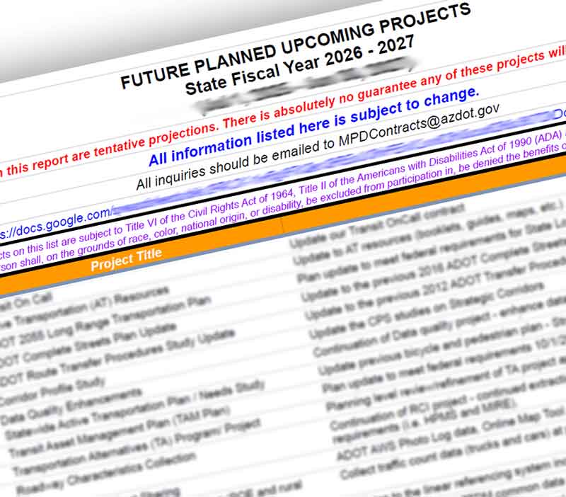
Planning
-
-
View ADOT's Public Involvement PlanADOT welcomes and encourages public involvement in the decision process.
-
State budget provides
funding for full I-17
widening project north
of ValleyPlan also advances
transportation projects across
Greater Arizona
PAGES INDEX
- Infrastructure, Investment and Jobs Act
- Transportation Planning
- Transportation Programming
- Data and Information
- GIS
- Transportation Programs
- Overview
- Active Transportation Program
- Arizona-Sonora Border Plan
- Arizona State Aviation System Plan (SASP) Update
- Arizona State Freight Plan
- Arizona Tribal Transportation
- Asset Management
- Complete Transportation Guidebook
- Key Commerce Corridors
- Performance Management
- State Long-Range Transportation Plan
- State Rail Plan
- Transit Programs and Grants
- Airport Development
- Grant Coordination
- Research Center
- Contact Planning
- Transportation Studies
- Overview
- Completed Transportation Studies
- Corridor Profile Studies
- Arizona Electric Vehicle Program
- Arizona Port of Entry Study
- Arizona State Highway-Rail Grade Crossing Action Plan
- Arizona Statewide Rest Area Study
- Binational Freight Corridor Study
- Binational San Luis Transportation Study
- Douglas International POE Connector Road Study
- Grand-35 Study
- Grand Canyon National Park Airport Master Plan Study
- GCNPA Drainage Master Plan and Water Use Study
- I-10 / Loop 101 System Interchange
- I-10, Loop 202 to SR 387 (Wild Horse Pass Corridor) Study
- I-10 Gila River Bridges Study
- I-10/Jackrabbit Trail Traffic Interchange Study
- I-10 and SR 210 Study
- I-11 and Intermountain West Corridor Study
- I-15 Virgin River Bridge No. 1 Study
- I-17: Central Avenue Bridge Replacement Study
- I-17: Indian School Road Traffic Interchange Study
- Loop 101 Price Freeway Study
- Loop 303:SR 30 to Hassayampa Freeway Study
- Loop 303: I-10 to Proposed State Route 30
- Milton Road Corridor Master Plan
- Nogales Bicycle and Pedestrian Master Plan/Royal Road Multi-Use Path
- North-South Corridor Study
- Overhead Traffic Sign Structure Study
- Riggs Road Traffic Interchange at SR 347
- Sonoran Corridor Tier 1 Environmental Impact Statement
- SR 30: Loop 303 to Loop 202 Study
- SR 51 Ramp Meter Study
- SR 87 Corridor Development Study
- State Route 377 Safety Study: Heber-Overgaard - Holbrook
- US 60 Corridor Study (SR 74 to Wickenburg)
- US 93 at Pierce Ferry Road Feasibility Study
- US 180 Corridor Master Plan