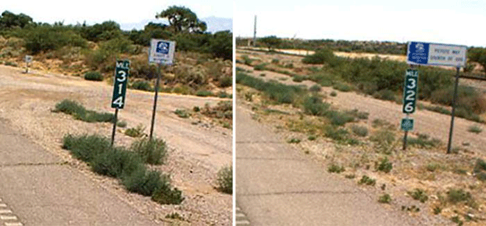
The case of US 70's missing 12 miles
The case of US 70's missing 12 miles

It's a MacGuffin worthy of a Ray Chandler novel or Indiana Jones movie: What happened to the missing 12 miles on US 70's mile markers in southeastern Arizona?
Those who have driven this highway between Bylas and Safford might have noticed that the mile markers suddenly jump from 314 to 326.
So what happened? Hilarious prank? Brazen theft? Tear in the space-time continuum?
The real answer is likely a lot more mundane. We can't say for sure, but here's an educated guess.
It helps to know that US 70 is an historic route with deep roots in the area. It was first commissioned in the mid-1930s as a transcontinental highway, but the Arizona portion follows the old Gila River Trail, used by wagons and railroads in the 1800s, and was a state highway in the early 1900s.
We do know that after Coolidge Dam created the San Carlos Reservoir along the Gila River the route of the highway was adjusted to lead to the new man-made lake. And that in 1956 it was adjusted back to the original – and shorter – route it still has today.
Because of that shift, our maintenance and engineering district serving the southeast part of Arizona says it's entirely possible the missing 12 miles come from what's known as an "equation," a jump in numbering that kept the current alignment's mileposts on track without having to change all the mile markers going to the New Mexico state line, some 60-plus miles to the east. Keeping the new alignment's mile markers consistent coming from the west was also important because at that time US 70 didn't end at Globe but the California state line.
So the 12 miles may not exactly be missing. But like all good MacGuffins, there's just enough mystery to keep us interested.
