How different sources expect winter weather to play out in Arizona
How different sources expect winter weather to play out in Arizona
Now that the monsoon has come and gone and fall-like weather is upon us, we look toward the winter season and the outlook for severe weather.
Last winter, a powerhouse El Nino pattern was expected to bring well-above-normal precipitation but instead brought mostly drier conditions to the state. The Pacific Northwest wound up receiving much of the precipitation as a persistent ridge of high pressure over the Southwest kept the storm track north of us.
We are currently in a mild La Nina pattern, but this may shift into what forecasters call a neutral phase.
Let’s review the winter outlook from the following sources: NOAA Climate Prediction Center, Old Farmer’s Almanac and The Farmer’s Almanac.
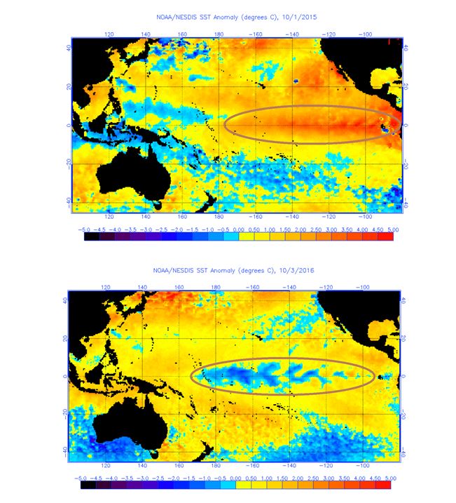
Sea surface temperature anomalies
Figure 1 (Top) - Pacific sea surface temperature anomalies for October 1st 2015. Notice the strong El Nino area within the encircled region. Last winter, arizona was drier than expected despite the presence of a strong El Nino. Source: NOAA-National Environmental Satellite Data and Information Services
Figure 2 (bottom) - pacific sea surface temperature anomalies for October 3rd 2016. Notice the weak La Nina area within the encircled region. Source: NOAA-National Environmental Satellite Data and Information Services
NOAA Climate Prediction Center
The Climate Prediction Center’s forecast is based on climatology trends, oceanography and computer model output from October 2016 through March 2017. This time period is broken into two three-month forecasts, the first running from October through December and the second from January through March.
At present, there is a 73-83 percent chance that temperatures will average above normal for fall and winter. Precipitation is expected to remain near the norm from October through December and then slide to below normal from January through March.
The probability of below-normal precipitation is between 66-73 percent, with the driest conditions expected in southeastern Arizona. This suggests that once winter settles in, high pressure will dominate our weather and keep the storm track to our north.
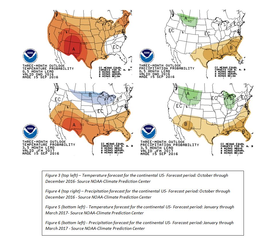
Temperature Forecasts
Old Farmer’s Almanac
The Old Farmer’s Almanac doesn't share the sources of its forecasts, but the results are nonetheless entertaining. Last year, its forecast for Arizona called for a drier-than-normal winter. With the exception of January, that was a fair assessment for most of the state. The almanac forecasts mild, dry conditions for Arizona this year.
Farmer’s Almanac
A competitor to the Old Farmer’s Almanac, the Farmer’s Almanac, places Arizona in a "balmy and wet" zone this winter, which seems strange when nearly the same weather is forecast for the Pacific Northwest. Typically, if we experience a wet winter then the Pacific Northwest will see normal to drier conditions. But anything is possible.
So two out of three sources are calling for above-normal temperatures and mostly below-normal precipitation. Keep in mind that these are outlooks take an average over an entire season, and while these long range outlooks can give us a general idea of what the winter conditions may be, they don't account for any short-term anomalies. For instance, a forecast of a mild and dry winter doesn't mean that the entire winter will be this way. Extreme weather can still occur and could wind up being more dangerous if people aren't prepared for it.
Whatever the weather brings this winter, make sure you're prepared by following our winter travel tips.
Editor's Note: ASU’s School of Geographical Sciences & Urban Planning has partnered with ADOT to place graduate-level meteorology students in the ADOT Traffic Operations Center. This allows ADOT to have better information about weather conditions and more quickly determine how to deploy crews and communicate with the public.