Wildlife Linkages
Wildlife Linkages
Biologists, engineers, planners and land managers from nine public agencies have worked together since 2004 to identify large blocks of protected habitat, the potential wildlife movement corridors through and between them, the factors that could possibly disrupt these linkage zones and opportunities for conservation.
Recognizing that habitat connectivity is a landscape issue involving multiple land jurisdictions, this workgroup has engaged in unprecedented cooperation and facilitated discussions and partnerships to help ensure a unified approach to wildlife linkage conservation and management.
This reinforces the commitment to and efficiency of wildlife connectivity measures undertaken by all stakeholders, using research and adaptive management in ongoing evaluations of those measures.
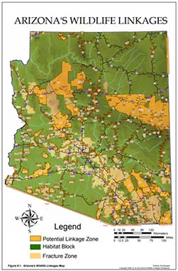
The assessment document (below) and map are the initial efforts to identify potential linkage zones that are important to Arizona’s wildlife and natural ecosystems. This is only the first step in a continuing process of defining critical habitat connectivity areas.
This nonbinding document and map serve as an informational resource to planners and engineers, providing suggestions for the incorporation of these linkage zones into their management planning to address wildlife connectivity at an early stage of the process.
If considerations for wildlife connectivity can be integrated into regional planning and projects early in the process, the linkage areas (or some portion of them) have the potential to be maintained or conserved during this time of growth and development.
Sections I-V
Section VI Maps
Section VI Arizona's Wildlife Linkages
- Figure 6 1 Arizona Wildlife Linkages
- Figure 6 2 Arizona Wildlife Linkages Across Habitat Blocks
- Figure 6 3 Arizona Fracture Zones
- Figure 6 4 Arizona Biotic Communities
- Figure 6 5 Landownership
- Figure 6 6 Tribal Nations
- Figure 6 7 USDA Forest Service
- Figure 6 8 Department of Defense
- Figure 6 9 Arizona Highway System with County Boundaries
- Figure 6 10 ADOT Engineering Districts
- Figure 6 11 ADOT Maintenance Districts
- Figure 6 12 ADOT Natural Resources Management Group
- Figure 6 13 Arizona Game and Fish Department
- Figure 6 14 Bureau of Land Management Districts
- Figure 6 15 Bureau of Land Management Field Offices
- Figure 6 16 Congressional Districts
- Figure 6 17 Council of Governments
- Figure 6 18 Federal Highway Administration Engineering Districts
- Figure 6 19 Legislative Districts