Interstate 10, Deck Park Tunnel to I-10/I-17 Split Study
Interstate 10, Deck Park Tunnel to I-10/I-17 Split Study
Contents
Overview
The Arizona Department of Transportation (ADOT), in cooperation with the City of Phoenix and the Maricopa Association of Governments (MAG), has begun a study of Interstate 10 (I-10) from the Deck Park Tunnel to the I-10/I-17 interchange, also known as the “Split” interchange, near Phoenix Sky Harbor International Airport, also known as Sky Harbor.
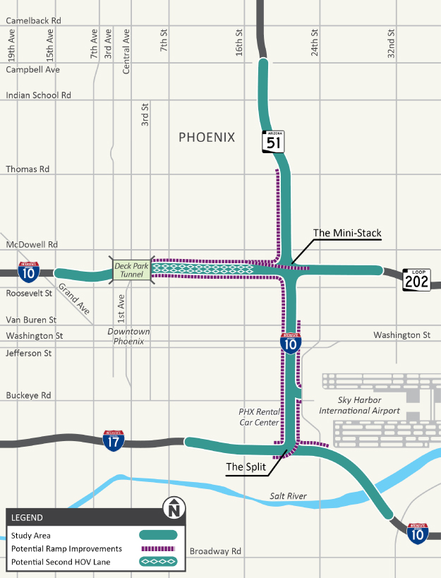
The study area also includes State Route 51 (SR 51) south of Thomas Road, the Loop 202 (Red Mountain Freeway) west of 24th Street and the entire interchange of I-10, SR 51 and Loop 202, also known as the “Mini-Stack.” Note: The map to the right shows the study area and a broader area where some related improvements may extend beyond the core corridor.
ADOT will prepare a Design Concept Report (DCR) and Environmental Assessment (EA) in accordance with the National Environmental Policy Act (NEPA). These engineering and environmental studies are required before decisions can be made regarding any proposed corridor improvements that may use federal funds.
The environmental process will conclude with either a Finding of No Significant Impact (FONSI) or a Notice of Intent to Prepare an Environmental Impact Statement, depending on the findings of the analysis.
Study Area Map
Background
In mid-2023, MAG began the Interstate 10 Freeway Corridor Study – Deck Park Tunnel to I-10/I-17 Split to identify potential alternatives for addressing safety and operational deficiencies within the corridor.
Several past studies provided important background information, including the I-10/I-17 Corridor Master Plan, also known as the Spine Study, and the I-10/Papago Tunnel Traffic Operations Study.
Additionally, MAG conducted extensive public outreach as part of the Corridor Study, including a public survey in 2023 and a public meeting in 2024 to obtain input on priorities and potential alternatives.
Using the information gathered from the public outreach and technical assessments, MAG published the I-10 Freeway Corridor Study, Deck Park Tunnel to I-10/I-17 Split, also known as the MAG Study, in January 2025.
The final report identified recommendations to improve safety and capacity along I-10 from the east side of the Deck Park Tunnel to the Split interchange, along SR 51 from Thomas Road south to the Mini-Stack and along Loop 202 from 24th Street west to I-10. The study did not identify improvements west of the Deck Park Tunnel.
The ADOT study team is using the information presented in these and other past planning efforts as a starting point for this study. Concepts identified previously may be refined, modified, screened or carried forward for evaluation as part of the DCR/EA process.
Purpose and Need
Traffic on I-10 in the study area is heavily congested during rush hours, and it is expected to worsen in the future. By 2050, average delay during peak travel times is expected to increase by up to 60 percent if no improvements are made.
Additionally, from 2016 through 2021, there were more than five crashes a day on average in the study corridor, with most being rear-end and sideswipe crashes.
The purpose of this study is to address traffic congestion, operational problems and safety issues on I-10 and its system connections in the study area, while maintaining access to downtown Phoenix and Sky Harbor.
Project Goals
- Improve safety
- Enhance traffic operations
- Enhance regional access to downtown Phoenix and Sky Harbor
- Minimize effects on surrounding communities and environmental resources
- Accommodate regional travel needs
- Enhance high-occupancy vehicle (HOV) access and mobility
Study Elements
Building on prior planning work, including the MAG Study, ADOT will evaluate a range of potential improvements in the study area, including:
- I-10 operational and safety enhancements, such as reducing merging and weaving movements, HOV lane continuity/connectivity and other operational improvements.
- Traffic interchange and system ramp improvements and freeway and ramp improvements, which may include additional on- and off-ramps, relocating on- and off-ramps, additional general purpose and/or HOV lanes and barrier-separated ramp or roadway concepts.
- Potential collector-distributor road concepts, where feasible, to reduce weaving and improve reliability.
- Maintaining or improving regional and local access and connectivity serving Phoenix Sky Harbor International Airport, as well as other important access considerations.
- Improvements to some adjacent streets and pedestrian/bike connectivity needs, where warranted, including relocating pedestrian crossings.
ADOT will also evaluate a No-Build Alternative, which assumes the proposed corridor improvements would not be constructed. This option provides a basis for comparing how future traffic, safety and access conditions could change with and without improvements.
Further study and evaluation will occur, and the public will have an opportunity to provide input, before any decisions are made regarding specific alternatives, locations or design.
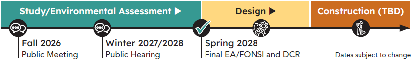
Schedule/Timeline
Opportunities for Input
ADOT conducted an online survey from June 1 to June 30 to seek input from the community to support the development of study alternatives.
During this study, there will be additional opportunities for the public to provide input.
- In fall 2026, ADOT will hold a public meeting to share and seek input on the design alternatives.
- In late 2027/early 2028, a public hearing will be held to share and seek input on the draft EA. Both of these meetings will include an in-person meeting and a virtual meeting, along with a 30-day comment period.
Subscribe for study updates below to stay informed.
Stay Informed
Subscribe to receive study updates by email.

Contact Us
- Phone: ADOT Project Information Line: 855.712.8530
- Email: [email protected]
- Mail: ADOT Communications, 1655 W. Jackson St., MD 126F, Phoenix, AZ 85007
The environmental review, consultation, and other actions required by applicable Federal environmental laws for this project are being or have been carried out by ADOT pursuant to 23 U.S.C. 327 and a Memorandum of Understanding dated June 25, 2024 and executed by FHWA and ADOT.