Alert icon

Current restrictions: Northbound Jackrabbit Trail between Roosevelt Street and McDowell Road closed nightly through March 28

Learn more

The Arizona Department of Transportation advises drivers to plan for the following closures for utility work at or near the I-10/Jackrabbit Trail interchange in the Buckeye area. 

  • Northbound Jackrabbit Trail will continue to be CLOSED nightly between Roosevelt Street and McDowell Road from 9 p.m. to 5 a.m. Monday through Thursday nights, and from 9 p.m. to 9 a.m. Friday and Saturday nights, through Saturday, March 28. NOTE: Drivers will not be able to access northbound Jackrabbit Trail from the I-10 off-ramps. 
    • DETOURS: Drivers may consider traveling southbound on Jackrabbit Trail to eastbound Roosevelt Street to northbound Perryville Road to westbound McDowell Road to access Jackrabbit Trail. Drivers may consider traveling westbound on Roosevelt Street to Verrado Way or eastbound on Roosevelt Street to Perryville Road to access I-10. 


Show less

I-10/Jackrabbit Trail Traffic Interchange Project

I-10/Jackrabbit Trail Traffic Interchange Project

Contents

Overview

The Arizona Department of Transportation (ADOT), in coordination with the Maricopa Association of Governments and the city of Buckeye, will be constructing a project to improve the interchange at Interstate 10 and Jackrabbit Trail.

A two-phased approach was created to expedite addressing traffic congestion at the I-10/Jackrabbit Trail interchange while continuing work on the overall project.

Phase 1 Planned improvements include:

  • Reconstructing the existing traffic interchange and adding traffic signals.
  • Widening the interchange ramps to provide additional turn lanes.
  • Removing and reconstructing the existing I-10 bridges over Jackrabbit Trail.
  • Widening Jackrabbit Trail to three lanes in each direction south of McDowell Road to south of Interstate 10

Phase 2 Planned improvements include:

  • Widening Jackrabbit Trail to three lanes in each direction south of the I-10/Jackrabbit Trail traffic interchange to just north of Van Buren Street.

In September 2024, ADOT completed the final Design Concept Report (DCR) for improvements at the I-10/Jackrabbit Trail traffic interchange.

ADOT developed the DCR and environmental evaluation based on current and projected traffic volumes that account for surrounding development at the interchange.

This project is included in the Regional Strategic Transportation Infrastructure Investment Plan and will be funded in part through Proposition 479, a dedicated half-cent sales tax for transportation approved by Maricopa County voters in 2024.

Project Area

I-10 and Jackrabbit Trail Traffic Interchange Map

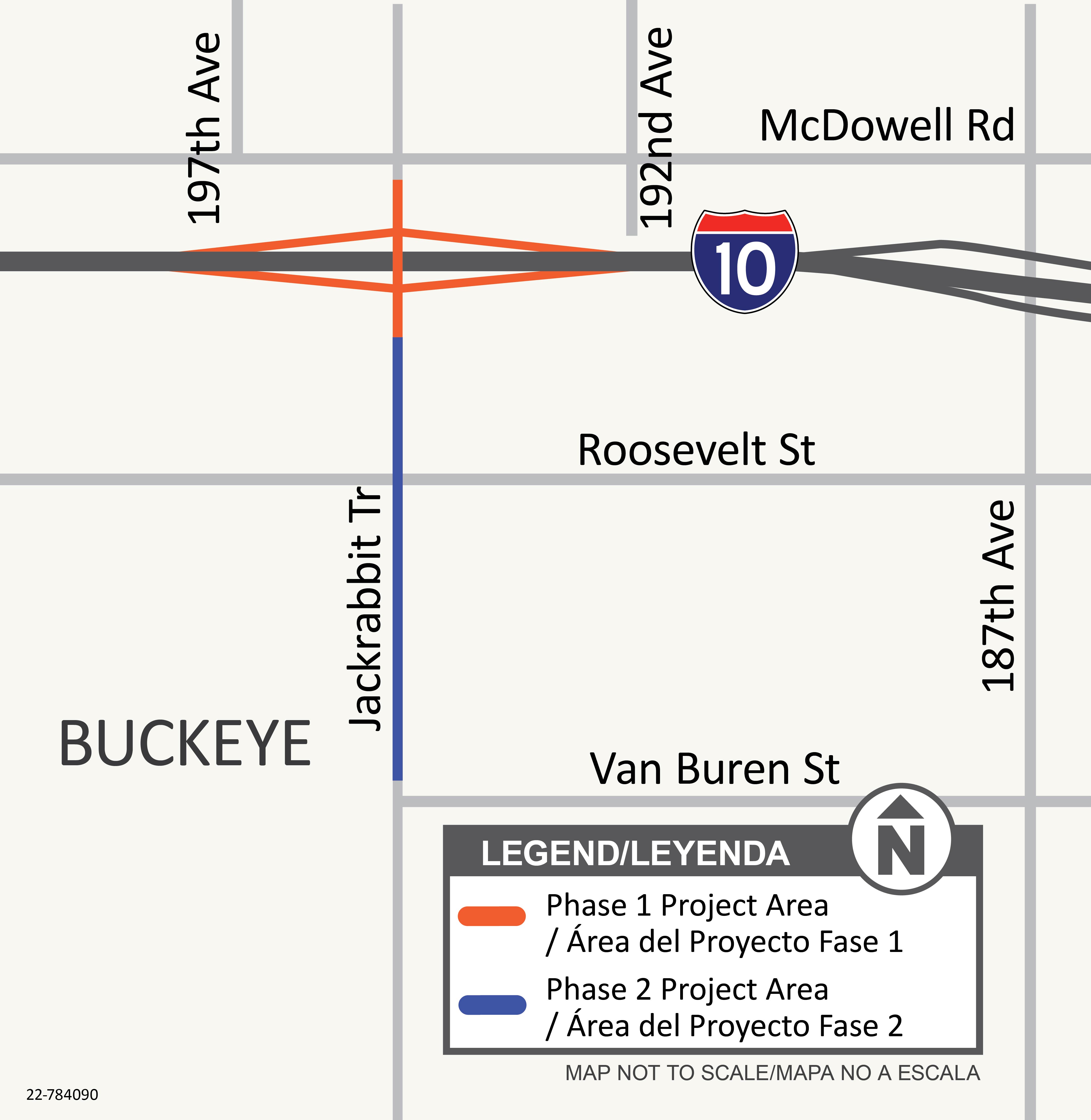
The Phase 1 project limits include the I-10/Jackrabbit Trail traffic interchange and extend from south of McDowell Road to north of Roosevelt Street.

The Phase 2 project limits extend from south of the I-10/Jackrabbit Trail traffic interchange to north of Van Buren Street.

Project Timeline

  • Phase 1 60% Design Presentation - Anticipated May 2025
  • Phase 1 Design Completion - Anticipated early 2026
  • Phase 1 Construction - Anticipated to begin in mid-2026
  • Phase 2 Design Completion - Anticipated Summer 2026
  • Phase 2 Construction - Anticipated late 2026


Stay Informed

...

Please subscribe to receive project updates by email.

ADOT welcomes your questions and comments. Please contact us in any of these ways:

  • Phone: ADOT Community Relations Project Manager: 623.695.7411 
  • Email: Nancy Becerra at [email protected]
  • Mail: ADOT Communications, 1655 W. Jackson St., MD 126F, Phoenix, AZ 85007