Interstate 17 (Black Canyon Freeway) Auxiliary Lane Improvements
Interstate 17 (Black Canyon Freeway) Auxiliary Lane Improvements
Contents
Overview
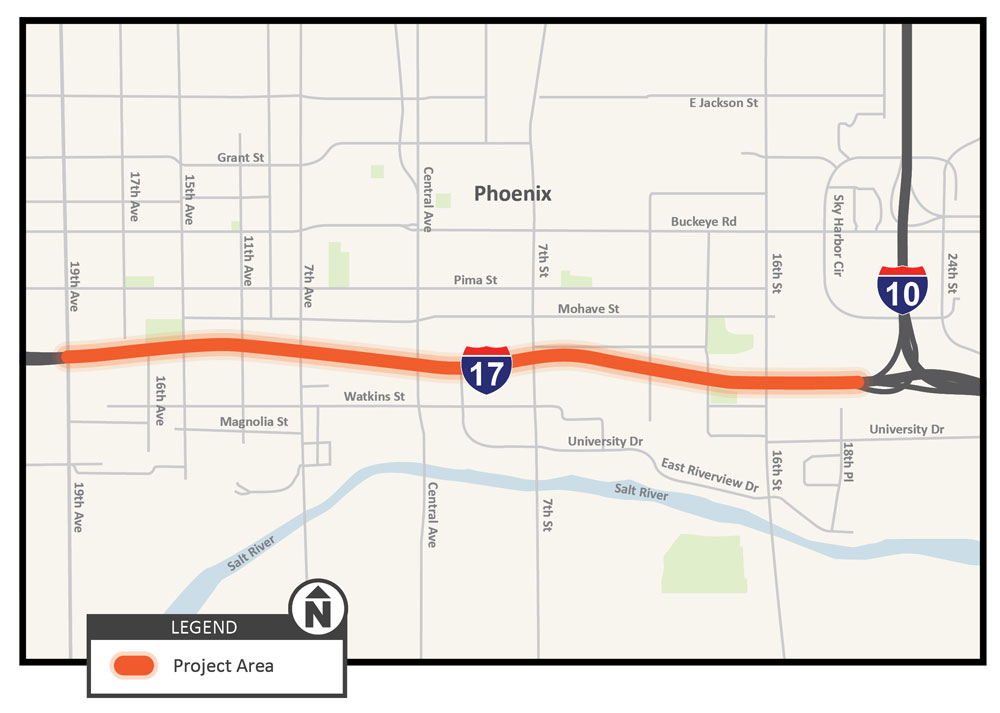
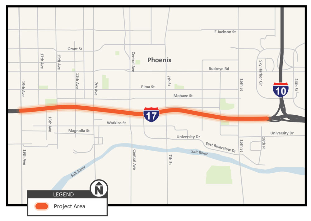
The Arizona Department of Transportation (ADOT), in cooperation with the Federal Highway Administration (FHWA), initiated an interim improvement project on Interstate 17 from the I-10/I-17 "Split" Interchange to 19th Avenue. Growing traffic demand has caused the I-17 corridor from the Split Interchange to 19th Avenue to become increasingly congested. This project will construct auxiliary lanes between the mainline on- and off-ramps to improve operations by providing additional length for traffic weaving movements in this corridor, while also minimizing the reconstruction of I-17.
Project Elements
This interim improvement project will do the following:
- Add auxiliary lanes on I-17 from 19th Avenue to 16th Street
- Replace the median lights with LED luminaires
- Construct new retaining walls
- Widen bridges associated with the auxiliary lanes
- Construct new northbound right-turn lane on 19th Avenue and an eastbound right-turn lane on the frontage road to mitigate traffic backups
Schedule
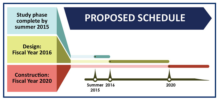
- The project is currently on hold
Stay Up to Date

Please subscribe to receive project updates by email.
Submit questions and comments or request information in any of the following ways:
- By Phone: ADOT English/Spanish Project Information Line: 855.712.8530
- Online: Visit azdot.gov/contact and select Projects from the drop-down menu
- By Mail: ADOT Communications, 1655 W. Jackson St., MD 126F, Phoenix, AZ 85007
2015 Study
The Arizona Department of Transportation (ADOT), in cooperation with the Federal Highway Administration (FHWA), initiated a Project Assessment (PA) and environmental study to evaluate near-term freeway operational improvements on Interstate 17 (I-17) from the I-10/I-17 "Split" Interchange to 19th Avenue.
Study Process
The purpose of this PA and environmental study is to evaluate near-term freeway improvement options and recommend a preferred alternative that meets the goals of the Regional Transportation Plan Freeway Program (RTPFP), satisfies the requirements of the National Environmental Policy Act (NEPA), and obtains public support. This study will evaluate the addition of auxiliary lanes on I-17 between the entrance and exit ramps in both directions between the I-10/I-17 system interchange and 19th Avenue. Design options and potential impacts will be evaluated and considered for this study. Potential environmental impacts will be documented in an environmental document following the requirements of NEPA.
Study Purpose
Growing traffic demand has caused the I-17 corridor from the I-10/I-17 Split Interchange to 19th Avenue to become increasingly congested. This study will evaluate the addition of auxiliary lanes between successive entrance and exit ramps to improve operations by providing additional length for traffic weaving movements in this congested corridor.
Initial Concept for Improvements
Study related comments and questions were considered by the project team and addressed in the PA and draft environmental document. The potential improvements could include the following:
- Provide auxiliary lanes between successive entrance and exit ramps.
- Maintain existing I-17 alignment with auxiliary lane widening to the outside.
- Implement two lane entrance ramps with ramp metering.
- Increase the distance between the ramps and the frontage road intersection with the cross roads.
- Maintain the existing cross road conditions.
- Minimize right-of-way impacts.
Proposed Schedule
Related Studies
Additional freeway improvement studies within the Interstate 10/Interstate 17 corridors include the Maricopa Association of Governments (MAG), study of the I-10/I-17 corridor, called the Spine Corridor Master Plan. The Spine Study, being performed in partnership with ADOT and FHWA, will analyze various long-term strategies to improve mobility in the corridor. The second study, by ADOT in partnership with FHWA and MAG, is the Interstate 10 Near-Term Improvements from SR 143 to the Loop 202 (Santan Freeway), which will analyze freeway capacity improvement options. All three studies will be conducted through separate efforts but will integrate information gathered for recommended overall corridor improvements. Additional information on the Spine Study can be found by calling 602.759.1916.
In 2015 public comments were submitted through the following methods:
Mail: c/o ADOT Community Relations:
1655 W. Jackson St., MD 126F
Phoenix, AZ 85007
Email: [email protected]
Phone: 855.712.8530
Project Map