State Route 88

Heed the warning signs on a reopened stretch of Apache Trail

Heed the warning signs on a reopened stretch of Apache Trail

SR24-1

Heed the warning signs on a reopened stretch of Apache Trail

Heed the warning signs on a reopened stretch of Apache Trail

By Garin Groff / ADOT Communications
September 18, 2024
Map of SR 88 with four-wheel drive area marked

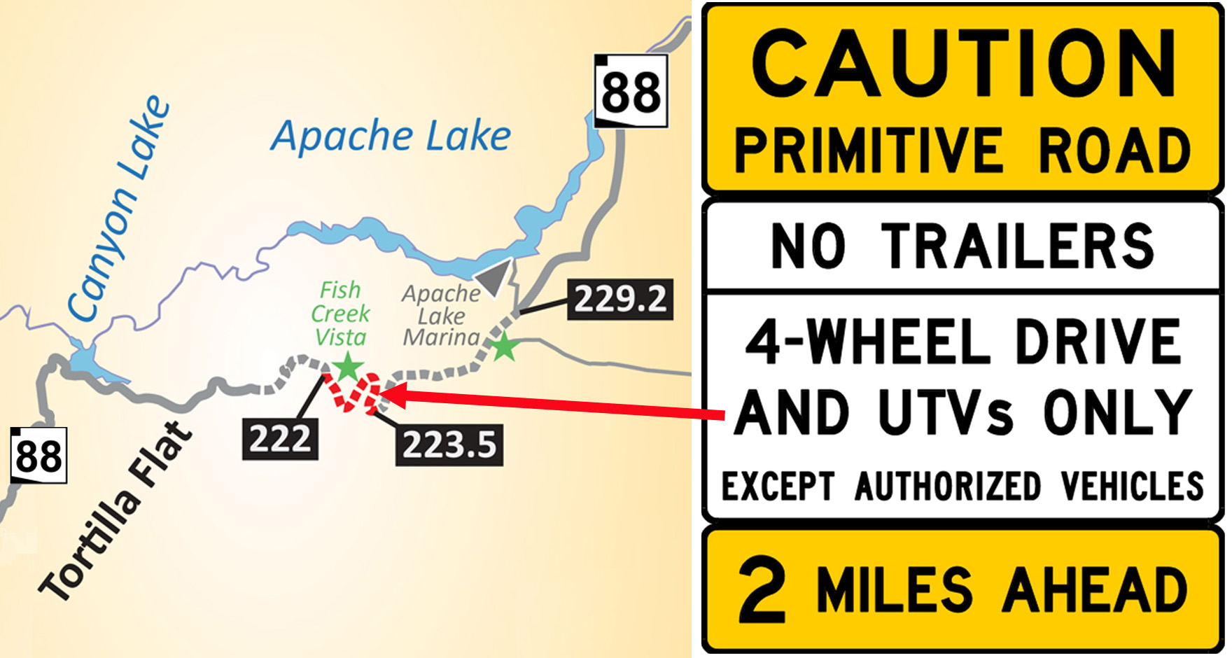
Before ADOT reopened a section of SR 88 Monday following a 5-year-closure, we installed signs that you don’t ordinarily find on a state highway:

CAUTION: PRIMITIVE ROAD
No Trailers
4-Wheel Drive and UTVs Only

That’s because this unpaved stretch of Apache Trail, between mileposts 222 and 227 east of Tortilla Flat, is anything but ordinary.

It includes a steep, narrow, winding section on Fish Creek Hill, some of it along a cliff. Conditions there can change following every rainfall, meaning today’s roadway may not resemble what you’ll encounter following the next weather event. Keep in mind that it was catastrophic rainfall in 2019 that closed this section in the first place.

The project that restored limited access on this historic highway is an interim one. ADOT continues seeking federal funding for a $33 million project needed to restore access to all vehicles. 

Just how historic is the roadway? It was built so crews from the East Valley could reach the construction site for Roosevelt Dam, which was completed in 1911. Sections maintain many of the original features, including drainage systems built of stone.

Amid these warnings, there continues to be good news for motorists with passenger vehicles who want to visit this scenic area. Much of the Apache Trail is accessible without a four-wheel drive. SR 88 is paved from where the highway begins in Apache Junction and for several miles east from Tortilla Flat at milepost 213. Those taking boats to Apache Lake or reach the Reavis Ranch Trailhead can continue doing so from State Route 188 at Roosevelt Lake. 

For more information on the SR 88, please visit azdot.gov/SR88ApacheTrail.

SR 88 stretch reopens for high-clearance four-wheel drives

SR 88 stretch reopens for high-clearance four-wheel drives

I-17 101 traffic interchange

SR 88 stretch reopens for high-clearance four-wheel drives

SR 88 stretch reopens for high-clearance four-wheel drives

September 16, 2024

ADOT completes project restoring limited access to mileposts 222-227

PHOENIX – A stretch of State Route 88 (Apache Trail) closed since catastrophic flooding in 2019 has reopened as a primitive road suitable for use only by high-clearance four-wheel drive vehicles and utility terrain vehicles.

Working closely with area stakeholders, the Arizona Department of Transportation completed a $4 million interim project to restore limited access to mileposts 222-227. The reopening comes with signs carrying this emphatic warning:

CAUTION: PRIMITIVE ROAD
No Trailers
4-Wheel Drive and UTVs Only
(Except Authorized Vehicles)

These signs apply to the steep, winding stretch of State Route 88 between the last eastbound turnaround point, Fish Creek Vista at milepost 222, and the bridge crossing Fish Creek at milepost 223.5. The last turnaround for westbound traffic is Reavis Trailhead Road at milepost 227.6.

Motorists towing trailers and boats can continue to safely access Apache Lake traveling on the east side of SR 88 from State Route 188, while Canyon Lake, Tortilla Flat and other points west of the restricted section remain accessible from the East Valley. 

ADOT continues seeking federal funding for more extensive upgrades, estimated to cost $33.7 million, that would make the stretch accessible to other vehicles and more resilient to storms.

“We understand Apache Trail’s place in the hearts of many Arizonans and are proud to have restored this limited access for people with the proper vehicles,” said Greg Byres, ADOT State Engineer and Deputy Director for Transportation. “We are committed to exploring all possible funding opportunities to continue expanding access in the future.”

A 5-mile stretch of SR 88 has been closed between Fish Creek Vista and the Reavis Trailhead turnoff since the 2019 flooding, which was made worse in areas by runoff from the Woodbury Fire scar. ADOT reopened 1.7 miles west from Apache Lake Marina to Reavis Trailhead Road in 2022. 

Traveling between the East Valley and Roosevelt Lake, Apache Trail was built during construction of Theodore Roosevelt Dam, which was completed in 1911. Prior to closing in 2019, the stretch between Tortilla Flat and Apache Lake was used by an average of 232 vehicles daily.

ADOT has performed extensive work since 2019 to restore access to and improve other damaged sections of SR 88 and made regular repairs when flooding has damaged areas that are open to traffic. 

A separate federal project that continues upgrading SR 88 between Roosevelt and Apache lakes. Motorists can expect the highway to be closed in that stretch from 7 p.m. to 7 a.m. Sunday evenings through Thursday mornings. 

For more information on the SR 88, please visit azdot.gov/SR88ApacheTrail.

State Transportation Board OKs plan to restore limited SR 88 access

State Transportation Board OKs plan to restore limited SR 88 access

I-17 101 traffic interchange

State Transportation Board OKs plan to restore limited SR 88 access

State Transportation Board OKs plan to restore limited SR 88 access

January 12, 2024

Interim ADOT project involves 5 miles damaged by 2019 flooding

PHOENIX – The State Transportation Board has approved the Arizona Department of Transportation’s plan to restore limited access to 5 miles of State Route 88 (Apache Trail) damaged by flooding in 2019 while seeking funding for more extensive upgrades needed to make the roadway more resilient and accessible.

ADOT’s $4 million interim plan is designed to restore the unpaved roadway to a condition that can accommodate vehicles with high clearance or four-wheel drive, as well as utility terrain vehicles. 

SR 88 closed in 2019 between Fish Creek Hill Overlook and Apache Lake Marina Road (mileposts 222-229) when flooding exacerbated by runoff from the Woodbury Fire scar extensively damaged the gravel roadway and left a section blocked by boulders. Flooding also damaged the drainage system, guardrail and bridge approaches and left unstable rock faces, creating safety issues and making the road vulnerable to additional damage and closures. In 2022, ADOT reopened 1.7 miles west from Apache Lake to restore access to the Reavis Trailhead at milepost 227.

ADOT’s interim plan calls for removing boulders on Fish Creek Hill, mitigating rockfall as needed between Fish Creek Hill Overlook and Fish Creek (mileposts 222-223.5), making repairs to retaining walls, installing new signage, cleaning and potentially replacing damaged drainage culverts, and taking other steps to safely reopen the highway for high-clearance or four-wheel drive vehicles.

Maintenance crews are scheduled to begin work on preliminary items ahead of the construction project like removing vegetation, filling in eroded areas in the road surface and cleaning out culverts, beginning in February. Contracted construction work is expected to begin later this year. Before ADOT can schedule work, the U.S. Forest Service must review and approve the interim project design, since SR 88 follows an easement through federal land. In addition, the project must be designed to meet all applicable state and federal environmental requirements.

ADOT’s long-term plan for SR 88, developed through extensive public involvement and study, is designed to improve its resilience to severe weather. The recommendation calls for $33.7 million in improvements including: 

  • chip sealing, in which aggregate is compacted into heated asphalt liquid to create a more durable road surface, throughout the 5 miles;
  • widening the roadway to 15 feet in steeper areas;
  • increasing drainage capacity to accommodate heavier rainfall; 
  • rehabilitating or repairing existing bridges; and 
  • adding pullouts and other safety enhancements. 

The longer-term plan does not have dedicated funding, and ADOT is pursuing federal funding to advance those improvements.

Traveling between the East Valley and Roosevelt Lake, Apache Trail was built during construction of Theodore Roosevelt Dam, which was completed in 1911. Prior to closing in 2019, the stretch between Tortilla Flat and Apache Lake was used by an average of 232 vehicles daily.

ADOT has performed extensive work since 2019 to restore access to and improve other damaged sections of SR 88 and make regular repairs when flooding has damaged areas that are open to traffic. Motorists can safely access Apache Lake and other points on the east side of the closure via SR 188 and can travel 9 miles east from Tortilla Flat, which has been accessible throughout from the west. In addition, an $18 million project administered by the Federal Highway Administration’s Central Federal Lands Highway Division is currently chip-sealing 11 miles between Apache Lake and SR 188 near Theodore Roosevelt Dam. 

For more information on SR 88, please visit azdot.gov/SR88Study.


With forest closure, SR 88 closed east of Tortilla Flat, west of Roosevelt Lake

With forest closure, SR 88 closed east of Tortilla Flat, west of Roosevelt Lake

I-17 101 traffic interchange

With forest closure, SR 88 closed east of Tortilla Flat, west of Roosevelt Lake

With forest closure, SR 88 closed east of Tortilla Flat, west of Roosevelt Lake

July 2, 2020

PHOENIX – Due to a closure of most parts of the Tonto National Forest, State Route 88 has been closed east of Tortilla Flat and between Roosevelt and Apache lakes.

The eastbound closure of SR 88, also known as the Apache Trail, begins at milepost 213 beyond Tortilla Flat, which remains accessible. The westbound closure begins at State Route 188. 

An unpaved section of SR 88 from Apache Lake west to Fish Creek Hill, which is east of Tortilla Flat, is closed indefinitely. That 7-mile stretch was damaged extensively by flash flooding out of the area burned last year by the Woodbury Fire.

Information about Tonto National Forest restrictions is available at fs.usda.gov/tonto.