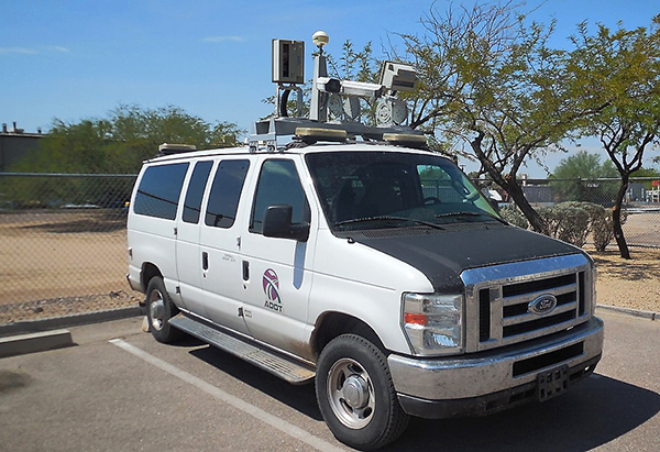
ADOT photolog van used to map state's highways
ADOT photolog van used to map state's highways
Tim O’Connor reached down and grabbed a bottle of Windex from the driver-side door storage compartment of the heavily-modified 2008 Ford E-350.
“We take a lot of bug hits,” O’Connor explained as he climbed atop the van and began wiping smudges from the lenses of a pair of high-definition cameras and lasers mounted atop the van.
O’Connor and Robert Bush are ADOT Transportation Photolog Specialists, tasked with recording and maintaining a comprehensive digital record of Arizona’s State Highway System.
“Every highway – both directions – every year,” said Bush.
Considering ADOT manages about 6,500 miles of highway, that’s no small assignment. Bush and O’Connor travel almost 23,000 miles a year in ADOT’s photolog van, capturing about four million images – that’s eight terabytes of data – used to create a historical record of ADOT’s highways.
As the van travels at highway speeds, the HD cameras record images every 10 meters and a powerful GPS device registers the location within inches of accuracy. At the same time, a pair of lasers scan the passing roadway and roadside 75 times per second, collecting about 22,000 data points per second. Taken collectively, these points produce a 3-D image of roadside assets, such as signs, poles and highway striping.
That’s a shortened, jargon-free explanation of how the cameras, lasers, GPS and computers work together, gathering images and data. There’s much more technology that goes into the process, which is called mobile mapping. Google maps “Street View” function is another example of mobile mapping. ADOT has a “Street View” of every mile of every highway, plus a majority of ramps, frontage roads and interchanges. While Google began experimenting with mobile mapping in 2007, ADOT started in the mid 1970’s when Google founders Larry Page and Sergey Brin were in diapers.
Back then, ADOT’s first photolog van had a 16-millimeter black and white film camera strapped to the inside of the windshield in place of a rear-view mirror. Over the years more cameras were added for more viewpoints. In 1991, video cameras were mounted on the van and recorded to SVHS tapes. ADOT switched to digital cameras in 2003 and has kept the same approach for the past decade. But technology has advanced and today’s results far exceed those of a decade ago.
“The first version (of the digital images) took about 75 gigabytes of data, for a full year” Bush said. “This one does eight terabytes a year – that’s about four million photos. And as the price of memory comes down, we have the capabilities to expand.
”Various ADOT divisions have uses for the photolog data. For instance, maintenance groups can access it to see what type of materials, such as guardrails and guardrail end treatments are needed to make repairs on a remote stretch of highway, rather than first traveling to the site. Striping crews can determine what areas need to be re-striped. Asset management and signing groups use it as complementary device to maintain massive inventory catalogs. Traffic Operations Center operators use it to view highway characteristics when incidents are reported.
Groups outside of ADOT, such as the Department of Public Safety, the state Attorney General’s Office, Arizona Game and Fish Department, Arizona State Parks, as well as county and city governments, have utilized photolog data.
Because of its volume of data, the photolog is a bandwidth hog and is not accessible outside of ADOT’s intranet.
Bush and O’Connor are on the road from early spring to late fall. They’ll hit northern Arizona in the summer when the sun is higher, producing fewer shadows, and southern Arizona in the spring and fall when weather is cooler and less stressful on the equipment.
“Our schedule is very detail-oriented to maximize the data collection and quality,” Bush said.
They do make special trips when necessary. After a landslide tore through a section of US 89 in February near Page, Bush and O’Connor photo logged Navajo Route 20 less than a week later to aid in the planning of what would become Temporary US 89. Bush said they plan to photolog US89T in mid-October.
Bush and O’Connor swap duties – one drives and the other operates the computers in the back of the van. During the photo logging season, they’re on the road four days a week and are witness to a variety of reactions when people see the van. Adults and children turn and stare at the van with quizzical looks.
Sometimes drivers will slow down, thinking the van, with all of its equipment, is tracking speeders. That’s not the case. A sticker on the side of the van reads, “This vehicle does NOT conduct Photo Enforcement. ”The only thing Bush and O’Connor hand out are bottles of water when they come across stranded motorists. In addition, they figure they’ve made a few-dozen motorist assists and once returned a wallet to a Utah resident they found on Alternate SR 89.
“We both feel a certain responsibility to the public,” Bush said.