Cameron Approach Road opened eastern gateway to Grand Canyon
Cameron Approach Road opened eastern gateway to Grand Canyon
Traveling today’s modern highways to the Grand Canyon, it’s hard to imagine the challenges motorists and road builders faced in the early days of the national park.
While the national park will celebrate its centennial next year, a paved road from Williams to the South Rim – State Route 64 – wasn’t completed until 1933. It is one of the state’s historic roads.
The highway east from Cameron to the Canyon was paved in 1936 after years of lobbying, creative financing and construction over difficult terrain from the Painted Desert to the pinyon and pine forest of the South Rim. Known as the Cameron Approach Road, it generally followed the Navahopi Trail used by Navajos and Hopis long before the national park existed.
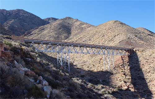
Much of that 1930s route and a key highway bridge were abandoned after several decades when SR 64 was realigned. The new alignment still connects Cameron to the Canyon, and the old bridge is plainly visible from the new route.
Building that segment of SR 64 and a key highway bridge was an important chapter of Arizona highway history that opened Grand Canyon to increased tourism by automobile.
“In a local and regional sense, the road is perfectly illustrative of Grand Canyon’s 1925-39 golden age of road building wherein the National Park Service and Superintendent Minor Tillotson transformed the park’s transportation system from rutted wagon roads to modern automotive highways,” Michael Anderson wrote in a report for the Historic American Engineering Record, an organization that documents historic sites and engineering feats.
This account is based on Anderson’s 1994 report.
Tillotson, Grand Canyon engineer from 1923-27 and superintendent until 1939, blazed the way for the eastern route to the national park. The Cameron road would ultimately link the South Rim to the North Rim via US 89 and Navajo Bridge, built by the Arizona Highway Department in 1929. It also advanced the Park Service’s goal of connecting its parks in Arizona to those in southern Utah.
In the late 1920s, the Fred Harvey Co., which provided tourist services at Grand Canyon, maintained a primitive road from the Canyon to Cameron. It followed a stage coach trail and the Navahopi route. Company buses took visitors to Cameron and Tuba City trading posts.
Tillotson argued for a new road and obtained funding for it in the early days of the Great Depression. In December 1929, the Arizona Highway Department, National Park Service and U.S. Forest Service each agreed to pay $5,000 to survey a new eastern route to the Canyon.
Later, land acquisition was temporarily sidetracked when the National Park Service director balked at paying $30 to two Navajo allottees for 16 acres of right of way.
Ultimately, it took nine projects totaling $1.06 million to build a 31-mile road from Cameron to the Canyon. That’s the equivalent of about $20 million today. One key project was a 300-foot bridge built at a cost of $45,000.
While work progressed on road-building, Phoenix contractor Vinson & Pringle started construction of the bridge Oct. 1, 1933. A 12-man crew was later increased to 23. The historic engineering report outlined some of the details of the 8-month bridge project:
- Daily pay was $4 for laborers, $5 for truck drivers, $8 for stone cutters and $10 for stone masons.
- Vinson & Pringle had a lot of job turnover for painters who were frightened by the heights of painting the bridge structure. Most were out-of-work house painters who were unaccustomed to working high above the ground.
- A landscape architect insisted on sandstone veneer for the bridge’s wing walls and abutments instead of concrete. The attractive stone walls matched those at Desert View.
The bridge was completed June 9, 1934. It carried SR 64 traffic for decades before the road was realigned. The bridge still spans a canyon 150 feet above the new alignment of SR 64. Barricades block the old road and the bridge.
The 7,100-foot Gray Mountains rise high above the bridge. The scenic Little Colorado River gorge is less than a mile north of the current alignment of SR 64.