Navajo Bridge: Making connections since 1929
Navajo Bridge: Making connections since 1929
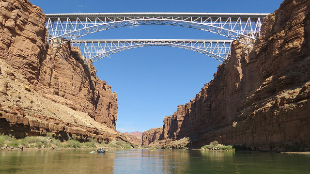
It's been more than 90 years since crews completed the original Navajo Bridge, an arching, architecturally significant span that looms dramatically across Marble Canyon and provides a rare vehicle crossing of the Colorado River in a remote, rugged part of the Southwest.
On Jan. 12, 1929, the first traffic rumbled across what was then the world’s highest steel-arch bridge. While a grand opening celebration would wait until June, that day marked a pivotal moment in Arizona’s economic and transportation development. This milestone of engineering design carried travelers 467 feet above the river to connect the Arizona Strip with the rest of the state.
“As the only crossing of the Colorado River for some 600 miles, the Navajo Bridge has had a profound impact on the commerce and transportation of a rugged, remote and isolated part of Arizona,” designer Clayton Fraser is quoted as saying in the National Park Service’s “Historic American Engineering Record.”
“An extraordinarily dramatic span high over the Grand Canyon, the Navajo Bridge is Arizona’s most aesthetically and functionally successful example of civil engineering,” Fraser said.
For half a century before that, travelers used Lees Ferry at the bottom of Marble Canyon several miles upstream from where the bridge was built. According to the Engineering Record, boat crossings began in 1873, and the ferry was the primary passage until the opening of the Navajo Bridge, which was first called the Grand Canyon Bridge.
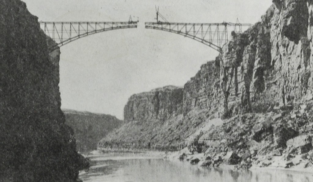
Throughout construction of the 834-foot-long, 18-foot-wide span, the biggest challenge was the river itself, which, according to the Engineering Record, “cut through the road like a giant slash in the desert fabric.”
Laborers toiled long hours from dizzying heights above the river. Crews drilled and graded rocky bluffs. Supplies were carried on precarious footing.
It was with little fanfare that the Arizona Highway Department, the former name of the Arizona Department of Transportation, opened the bridge on Jan. 12, 1929. A chill wind blew on the few laborers and engineers who gathered in acknowledgement.
A gala ribbon cutting was scheduled during balmier weather on June 14-15.
As quoted in Engineering Record, The Arizona Republican, as The Arizona Republic was named at that time, described the scene as follows:
“Under a typical Arizona cloudless sky, the heat tempered by a gentle, southern breeze, the Grand Canyon Bridge across the chasm of the mighty Colorado river was formally dedicated by four governors of neighboring states this afternoon in the presence of a crowd of more than 5,000 persons, representatives of least 20 states.
“As movie and other cameras clicked and with three other chief executives of as many states standing by, (then) Governor John C. Phillips clipped the purple and yellow ribbons which represented the breaking of an age-old barrier between the lands to the north and south of Colorado River.”
The structure still exists today, though it has been a pedestrian bridge since 1995, when a new vehicle bridge was built 150 feet downstream to handle heavier, wider vehicles of contemporary times.
The 1995 bridge is, as progress would dictate, longer, higher and with an increased steel arch length than the original, among other signicant updates. But the biggest difference, as you can guess, is dollars and cents. It cost $390,000 to build the historic bridge, while the modern span cost $14.7 million.
We've done blog posts about the bridge before, including a before-and-after view and an explanation of how ginger ale played a part in the bridge's hstory. If you are interested, you can also find a more detailed history of this important structure from the primary resource used in this report, National Park Service’s “Historic American Engineering Record.” Also of interest is a more recent report from the National Park Service.