From the Archives: Aerial view of Interstate 19
From the Archives: Aerial view of Interstate 19
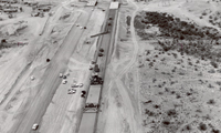
This photo found in the ADOT archives takes us back to 1964 and the construction of Interstate 19. It shows a section of highway south of Tucson. If you look closely, you can see the vehicles are clearly from the 60s.
I-19 is known for being the only continuous highway in the country with signs measuring distances in kilometers. An Arizona Highways blog post gives more history on the use of the metric system on I-19.
It’s safe to say things have changed since 1912 when the Arizona Highway Department was first established. But you don’t just have to take our word … we’ve got plenty of pictures to prove it. We combed through our archives and decided to periodically post these photos from the past in a blog series we’re calling, “From the ADOT Archives.”