Flashback Friday: 'Best announcement' advances Nogales-Tombstone highway
Flashback Friday: 'Best announcement' advances Nogales-Tombstone highway
Ninety-eight years ago, the Tombstone Epitaph's front page shared "about the best announcement that has come to Cochise County on road work for some time."
The State Highway Department's top engineer, Thomas Maddock, informed the newspaper that work had been approved to extend an existing 8.5 miles of highway between Tombstone and Fairbank, a stretch completed in 1919, west to the Santa Cruz County line. That was part of plans to create a highway linking Tombstone and Nogales along the path that today carries State Route 82. The story said Engineer Al Jenkins was moving a construction crew to Cochise County.
"Telephone advices received later from Mr. Jenkins from Patagonia were to the effect that he was breaking camp and loading all equipment today, ready to move tomorrow, and will begin throwing dirt Tuesday," it said.
That was Tuesday, Feb. 7, 1922, so today is the anniversary of that dirt-throwing.
Various accounts from the time say this highway was an offshoot of the cross-country Bankhead Highway, which followed the path of what was then US 80 (now State Route 80) from the New Mexico line through Douglas, Bisbee, Tombstone and Benson. It then went to Tucson, Phoenix and eventually Yuma. According to the Arizona Republican, one goal of a Tombstone-Nogales highway was linking the Bankhead Highway with Mexico's highway between Mexico City and Nogales. That would create a valuable international connection for what was billed at the time as the USA's only all-weather coast-to-coast route.
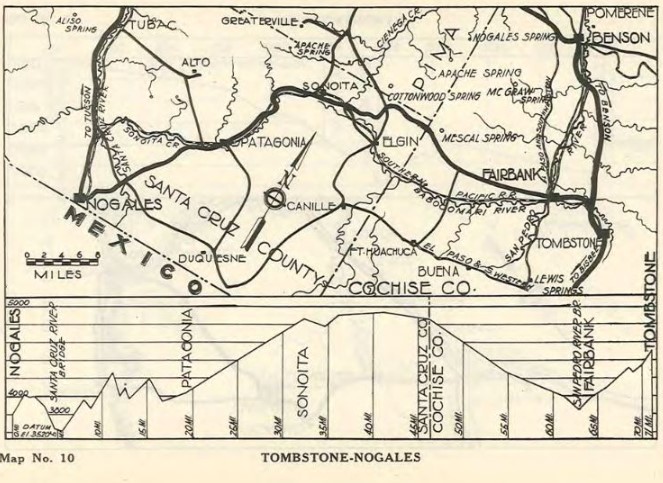
The map at top right, from a mid-1920s Highway Department report, shows the route of the Tombstone-Nogales highway.
For the work creating 15 miles of highway between Fairbank and the Santa Cruz County line, grading with heavy equipment was to start at both ends, the Tombstone Epitaph said. The article spends quite a bit of time explaining the three camps being established to make this happen, including one at a ranch midway "for equipment, stock and other material." The interactive map at lower right allows desktop and tablet users to learn more about sites important to this construction project.
"The news that work will be started will bring joy to both Santa Cruz and Cochise county road advocates," the article said.
A 1924 biennial report from the Highway Department's state engineer said crews had completed 52.3 miles, from Tombstone to Patagonia, of what would eventually be a 74.3-mile gravel highway. It noted that the 25 miles in Cochise County had been turned over to the maintenance department by construction crews.
"This highway throughout is constructed along modern lines and is in excellent condition and repair," the report said. "With possibly the exception of a few miles in Cochise County, which should be sanded where the caliche surface during wet weather is inclined to become somewhat slick, only general maintenance is necessary."
Now State Route 82, the highway passes through gorgeous country, as you can see through these Google Street View images from Fairbank, Sonoita, Patagonia and approaching Nogales. You'll notice that today's highway is no longer gravel, so that somewhat slick caliche surface has long since been taken care of.
Next time I drive it, I'll think about the day almost a century ago when Al Jenkins' crew began "throwing dirt" to make this beautiful highway a reality.