New online tool allows you to virtually "drive" Loop 303/I-10 interchange
New online tool allows you to virtually "drive" Loop 303/I-10 interchange
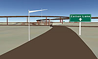

A screen shot from the Loop 303 virtual drive.
What if Wouldn’t it be nice to see what a new road is going to look like before it’s built in your community?
We’re talking about more than just a two-dimensional map…
you were able to “virtually” drive on the new stretch of road and see the views around your neighborhood? Imagine if you could get a glimpse of what a freeway ramp would look like from the vantage of the road?
Sounds like something out of science-fiction, right?
Wrong. The future is here today!
OK, maybe we’re exaggerating a bit. But, ADOT does have a new tool that allows you to get an idea of what the new Loop 303/I-10 ramps will look like once they’re finished.
Developed in cooperation with ASU’s Decision Theater, the virtual drive utilizes Google Earth so you can experience the new drive virtually.
It’s pretty cool and we invite you to go give it a try. Even if you don’t live or work in the West Valley, it’s still fun to take a look!
There’s even a comprehensive tutorial in case you need a little help getting started.
This tool is a new one for ADOT and we definitely want to know your thoughts on whether or not taking a virtual drive gives you a better understanding of the project. That’s why there’s an online survey you can take after you “drive” around a bit on the site.
More about the project
When this portion of the project is complete in 2014, drivers can expect many improvements, including ramp connections between Loop 303 and I-10 and a widened Loop 303 (it’s going to be a six-lane freeway – three lanes in each direction!) extending from I-10 in Goodyear to US 60 in Surprise.
You can always find details about the project on the Loop 303 project Web page and, of course, we’ll continue to keep you updated here on the blog!