Understanding all the Valley freeway nicknames
Understanding all the Valley freeway nicknames
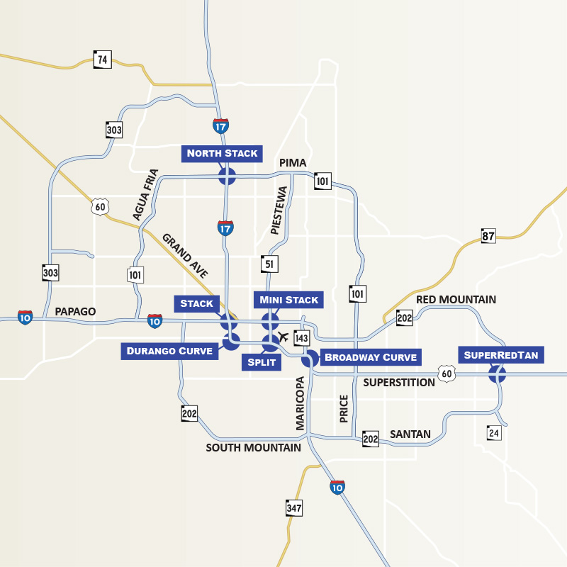
Editor's note: The map has been updated to include the Loop 202 South Mountain Freeway and Loop 303 which were completed after this blog was written.
In every city, transportation landmarks are given nicknames. Denver claims a “Mousetrap,” Los Angeles boasts the “Four Level” and Seattle has its “S-curves.” These colloquialisms can be baffling to new residents and some long-timers, too.
Phoenix is no different. Perhaps you’ve heard a traffic reporter refer to slowing at the “Mini-Stack” or a crash at the “Split” and wondered what highway was affected?
Wonder no longer. We’ve compiled a list and created a map, explaining and locating popular nicknames to Phoenix’s transportation landmarks.
Stack – A four-level interchange connecting I-10 and I-17; located west of downtown Phoenix near 19th Avenue and McDowell Road.
Mini-Stack – A four-level interchange linking I-10 to State Route 51 and Loop 202 Red Mountain Freeway; located south of McDowell Road and east of 16th Street.
North Stack – Another four-level interchange, this one is located at the I-17 and Loop 101, north of Bell Road.
Split – The interchange where I-10 splits or merges – depending on your direction of travel – with I-17 near Phoenix Sky Harbor International Airport. Westbound I-10 splits into lanes that allow drivers to head north on I-17 or continue west on I-10.
SuperRedTan – A multi-tiered interchange in east Mesa where US 60 Superstition Freeway, Loop 202 Red Mountain and Loop 202 Santan meet. SuperRedTan is formed by taking part of each freeway’s name – Superstition, Red Mountain and Santan.
Broadway Curve – Southeast of the Split, this rush-hour-challenged section I-10 is near Broadway Road, and SR 143, by the Phoenix-Tempe border.
Durango Curve – The curved section of I-17 near Durango Street is located southwest of downtown Phoenix.