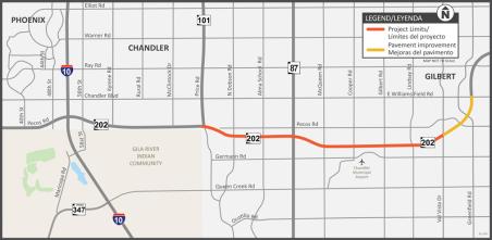
Volunteer group leader Arturo Delgado wasted no time heading out for a first cleanup on his newly adopted mile, located on State Route 87 from milepost 222 to 224. The segment is near the western trailhead to Mount Ord (external link) and was Delgado’s choice for the adoption.

Chart showing crash data
As it has annually since 2014, the Governor’s Office of Highway Safety awarded $72,000 to ADOT’s Crash Records section, which is responsible under state law for creating crash data reports that
I-19 Irvington Traffic Interchange Project Map
The Arizona Department of Transportation is initiating an improvement project at the Interstate 19 and Irvington Road traffic interchange. The project, located in Tucson will increase capacity and improve safety.
The latest episode of our podcast, On the Road With ADOT, features Brad Burgess, program administrator in the ADOT Broadband Office. Please spend a few minutes listening to him chat with our host, Doug Nintzel, about how ADOT is helping bring broadband internet to rural Arizona. 
I-40 Needle Mnt to Lake Havasu map.jpg

Project Cost: $24,777,783.80

Project Cost: $8,517,436.81

The Arizona Department of Transportation is working on two construction projects to replace the top-riding surface along 8 miles of Interstate 40 between the Arizona-California state line and the junction with State Route 95 (mileposts 0 to 8). 
ADOT is celebrating 23 new and renewed Adopt a Highway volunteer groups this quarter.
I-17 pavement work
The posted detour using the northbound I-17 frontage road moved traffic efficiently throughout the weekend, and ADOT is grateful to drivers who heeded advice to use this route. Law enforcement
The Blue Envelope Program works by allowing an individual to present a blue envelope when contacted by law enforcement to indicate that someone in the vehicle may interact differently during the situation. 
911

The Arizona Department of Transportation advises motorists traveling on US 93 near the community of Wikieup to plan for daytime restrictions May 20 - 23, along a 10-mile section of the highway.

Project Map - US 93 Pavement Project: Gunsite Canyon Road to Gray Wash

The following restrictions will be in place from 6 a.m. to 6 p.m. Monday, May 20 through Thursday, May 23:

  • US 93 will be narrowed to one lane only with alternating north- and southbound travel between Cedar Mine and Wikieup Hills roads (mileposts 120 to 130).
  • A rolling or short-term closure will be in place while US 93 is narrowed to temporarily stop all traffic while crews safely apply new pavement markings to the roadway. 
  • Drivers should be prepared to come to a complete stop when approaching and driving through the construction zone.

This is the final work on the US 93 Gunsite Canyon Road to Gray Wash Pavement Project, which included the following improvements:

  • Removing and replacing the top pavement surface.
  • Making spot pavement repairs, applying new pavement markings and other related work. 

ADOT reminds drivers to watch for construction personnel and equipment while construction is underway.
For more information, visit the project webpage.
 

Close alert
Show Low Regional Airport main building
This is the second time Show Low Regional Airport has been named the state’s Airport of the Year. The first was in 2007. It is one of 67 airports across Arizona that are publicly owned and publicly