
Custom Alert placed in Alerts region

Alert icon

Jackrabbit Trail Current Restrictions

Learn more

Starting Nov. 6, ADOT, in coordination with the Maricopa Association of Governments and the cities of Goodyear and Buckeye, will begin construction of a project to widen Interstate 10 from Verrado Way to Citrus Road to add a high-occupancy vehicle (HOV) lane in each direction. 

ADOT advises drivers to plan for the following upcoming closures for the first construction activities:

  • Eastbound I-10 will be CLOSED between Verrado Way and Citrus Road from 9 p.m. Friday, Nov. 6, to 5 a.m. Monday, Nov. 9. The following ramps also will be closed:
    • The eastbound I-10 on-ramps at Verrado Way, Jackrabbit Trail and Miller, Watson and Perryville roads.
    • DETOUR: Drivers may consider using eastbound Yuma or McDowell roads to access eastbound I-10 at Citrus Road.

For more information on this project please visit azdot.gov/i10SR85toCitrus.  


Show less
I-10/Jackrabbit Trail Traffic Interchange Project

I-10/Jackrabbit Trail Traffic Interchange Project

Contents

Overview

The Arizona Department of Transportation (ADOT), in coordination with the Maricopa Association of Governments and the city of Buckeye, will be constructing a project to improve the interchange at Interstate 10 and Jackrabbit Trail.

The project will be implemented in two phases

Phase 1 (construct traffic interchange) improvements include:

  • Reconstructing the existing traffic interchange and adding traffic signals.
  • Widening the interchange ramps to provide additional turn lanes.
  • Removing and reconstructing the existing I-10 bridges over Jackrabbit Trail.
  • Widening Jackrabbit Trail to three lanes in each direction south of McDowell Road to south of Interstate 10

Construction of phase 1 improvements is anticipated to begin in August 2026 and take approximately two years to complete.

Phase 2 improvements include:

  • Widening Jackrabbit Trail to three lanes in each direction south of the I-10/Jackrabbit Trail traffic interchange to just north of Van Buren Street.

This project is included in the Regional Strategic Transportation Infrastructure Investment Plan and will be funded in part through Proposition 479, a dedicated half-cent sales tax for transportation approved by Maricopa County voters in 2024.

Project Area

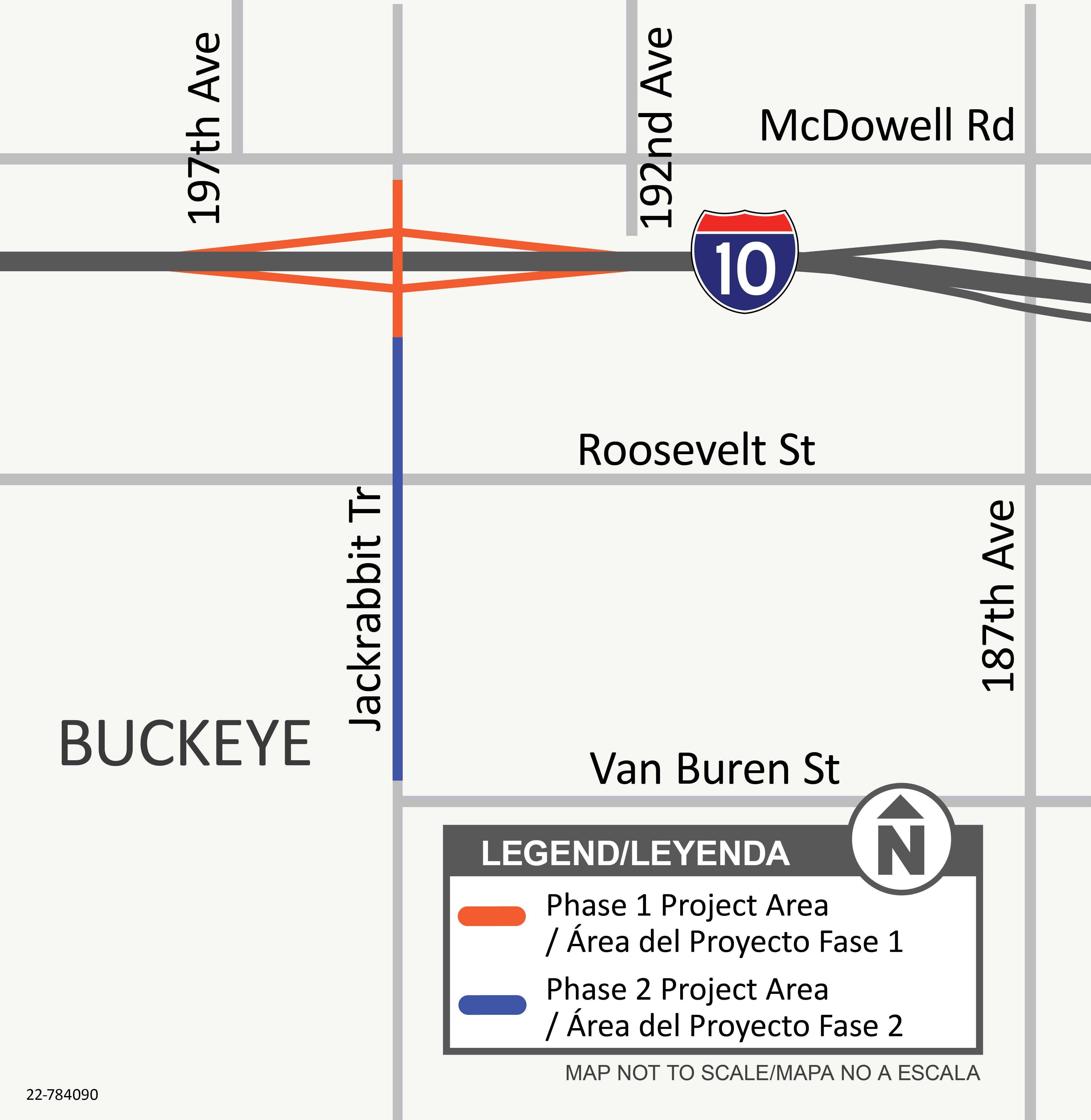
I-10 and Jackrabbit Trail Traffic Interchange Map

The Phase 1 project limits include the I-10/Jackrabbit Trail traffic interchange and extend from south of McDowell Road to north of Roosevelt Street.

The Phase 2 project limits extend from south of the I-10/Jackrabbit Trail traffic interchange to north of Van Buren Street.

What to Expect

Construction is scheduled to begin in early August 2026 and is expected to take approximately two years to complete. The project will require full closures and lane restrictions on I-10, Jackrabbit Trail and the I-10 on- and off-ramps at Jackrabbit Trail, primarily during overnight hours and weekends to minimize impacts to commuting traffic. Long-term ramp closures (approximately 45 days) and a 20-day closure of Jackrabbit Trail will also be needed to complete the interchange reconstruction. ADOT will provide advance notice of restrictions and closures to email subscribers and on the project web page.

Project Timeline

  • Phase 1 Design Completion - March 2026

  • Phase 1 Construction - August 2026 and take approximately two years to complete

  • Phase 2 Construction - Anticipated in 2028

Stay Informed

...

Please subscribe to receive project updates by email.

ADOT welcomes your questions and comments. Please contact us in any of these ways:

  • Phone: ADOT Community Relations Project Manager: 623.695.7411 
  • Email: Nancy Becerra at [email protected]
  • Mail: ADOT Communications, 1655 W. Jackson St., MD 126F, Phoenix, AZ 85007