State Route 89A: Glassford Hill Road to Coyote Springs Road Pavement Preservation Project
State Route 89A: Glassford Hill Road to Coyote Springs Road Pavement Preservation Project
Contents
This project is complete
Overview
Project Cost: $818,000
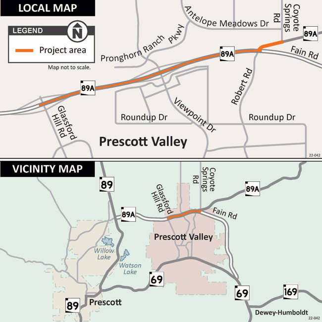
The Arizona Department of Transportation administered and completed a $818,000 project to remove and replace the existing top layer of pavement along State Route 89A from Glassford Hill Road to Coyote Springs Road (mileposts 322-325) in Prescott Valley. The project was completed in fall 2023.
The project includes the following:
- Remove and replace the top layer of pavement on north- and southbound lanes.
- Reinstall roadway striping and other pavement markings.
Project Area Map
What to Expect
While the project work is underway, motorists will encounter alternating lane restrictions. One one lane of traffic will be maintained in each direction throughout construction. Drivers should plan for possible delays while the work is underway.
Restrictions and Closures
For information about project-related restrictions and closures, please visit az511.gov or call 511, except while driving.
ADOT will provide more information about project schedules and potential traffic impacts as information becomes available. Stay informed of traffic restrictions before they occur by subscribing to receive timely traffic alerts by email.
Schedules are subject to change on weather and other unforeseen factors.
Stay Informed

Email: Subscribe to receive project updates and traffic alerts.
Phone: ADOT Project Information Line: 855.712.8530.
Teléfono: Línea de Información del Proyecto ADOT: 855.712.8530
Online: Submit a question or comment through the ADOT website. Visit azdot.gov/Contact and then select Projects from the dropdown menu.
Twitter: Follow ADOT on Twitter (@ArizonaDOT) for real-time highway conditions statewide.

