State Route 30 (Tres Rios Freeway)
State Route 30 (Tres Rios Freeway)
Contents
State Route 30 Corridor Overview
The Arizona Department of Transportation (ADOT), in cooperation with the Federal Highway Administration (FHWA) and the Maricopa Association of Governments (MAG), has initiated a project to build a new freeway in the southwest valley, State Route 30 (Tres Rios Freeway). The new freeway will serve as a traffic reliever and alternate route to Interstate 10, crossing the cities of Buckeye, Goodyear, Avondale and Phoenix.
This project seeks to address population growth, economic development and employment patterns that have resulted in increased congestion on the existing regional freeway system and arterial streets in the area.
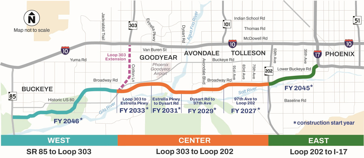
The SR 30 project was divided into three sections for planning purposes:
- Center: The center segment is located from the future southward extension of Loop 303 to Loop 202 (South Mountain Freeway). This section is funded for final design and construction. For more information on the center segment, visit the project web page.
- East: The east segment will extend from Loop 202 to Interstate 17. Preliminary design/environmental work is expected to begin in FY 2027 to determine the connection between SR 30 and I-17. Construction of this segment of SR 30 is slated to begin in FY 2045.
- West: The west segment of SR 30 will extend from SR 85 to Loop 303. This segment is currently in the early stages, with preliminary design and environmental work planned to start in FY 2027. Construction of interim improvements to this segment of SR 30 is currently planned for FY 2046. The interim improvements will be identified as part of the environmental/scoping effort for this segment.
Map of the proposed ultimate SR 30 corridor.
These three sections (center, east and west) are identified in the updated Regional Transportation Plan (RTP) for the Maricopa County region. The RTP identifies the center section (from Loop 303 to Loop 202) as the first to be constructed due to its potential to relieve congestion on I-10.
Project Fact Sheets
SR 30 West Section: SR 85 to Loop 303
Design of the west section of SR 30 is funded and scheduled to begin in FY 2027. Construction of this section is expected to begin after 2046.
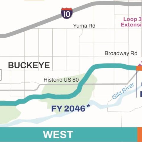
(Map of the SR 30 corridor west segment from SR 85 to Loop 303)
SR 30 Center Section: Loop 303 to Loop 202
This area of SR 30 is currently funded for advance right of way acquisition and for final design between 97th Avenue and Loop 202. For more information on this section of SR 30, please visit the project web page at azdot.gov/SR30-Center.
The center segment will be constructed in the following phases, from east to west:
- 97th Avenue to Loop 202: FY 2027
- Dysart Road to 97th Avenue: FY 2029
- Estrella Parkway to Dysart Road: FY 2031
- Loop 303 to Estrella Parkway: FY 2033
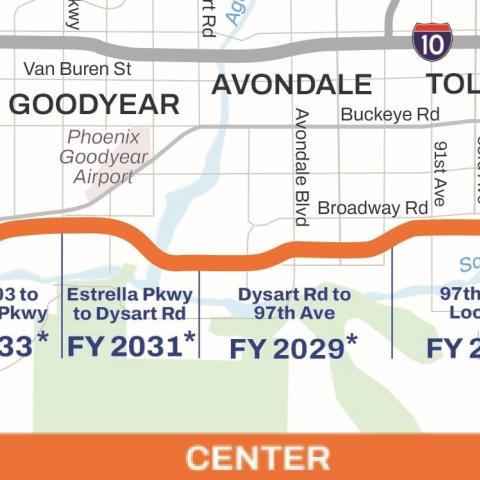
(Map of the center section of SR 30 from Loop 303 to Loop 202)
SR 30 East Section: Loop 202 to I-17 Durango Curve
MAG initiated a study to help lay the groundwork for future design, engineering studies, and National Environmental Policy Act (NEPA) documentation with a recommended SR 30 Durango Link corridor.
The study utilized a two-level screening process, first determining whether potential corridors met the purpose and need identified at the outset of the study, followed by a more detailed review of engineering, environmental, performance and implementation considerations. The ultimate corridor recommendation, shown on the map below, was based on a combination of inputs, including the technical screening process, feedback from the public and stakeholder input. The study identified the south corridor alternative as the preferred alternative.
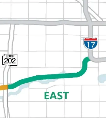
(Map of the proposed corridor alternatives for the east section of SR 30, from Loop 202 to the I-17 Durango Curve)
Construction of this facility is expected to help reduce the duration of traffic congestion on I-10 and I-17, and decrease travel times through and around the study area. The facility would also improve the reliability and redundancy of the transportation system by providing a second major east-to-west transportation facility in the southwestern Phoenix metropolitan area. Funding has been set aside for this facility in MAG’s most recent regional transportation plan, MOMENTUM.

Subscribe to receive project updates by email. Submit questions and comments or request information in any of the following ways:
- Phone: ADOT Project Information Line: 855.712.8530
- Email: [email protected]
- Mail: ADOT Communications, 1655 W. Jackson St., MD 126F, Phoenix, AZ 85007