Sonoran Corridor (SR 410) Study
Sonoran Corridor (SR 410) Study
Overview
The Sonoran Corridor (State Route 410) is envisioned as a continuous high-capacity freeway extending from Interstate 19 (I-19) to Interstate 10 (I-10) within Pima County. At this time, this potential freeway is in the study and planning stages.
The Sonoran Corridor study area is located within Pima County between I-10 and I-19, south of Tucson International Airport (TUS). For this study, there are two main planning stages: a Tier 1 Environmental Impact Statement (EIS) (completed in 2021) and a Tier 2 Environmental Impact Statement/Design Concept Report.
Background
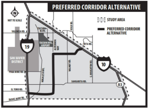
ADOT conducted a Tier 1 Environmental Impact Statement (EIS) study for the Sonoran Corridor, south of the TUS. Several reasonable alternatives were developed and evaluated by FHWA and ADOT as part of the Tier 1 study. The final approved Tier 1 study report identified a preferred 2,000-foot-wide corridor, as shown on the project map, for further analysis of a potential new freeway.
Study Area Map
A new freeway would:
- Improve vehicle mobility and the transportation system
- Improve access to existing and future activity centers
- Reduce persistent traffic backups and road congestion
- Address existing and future high-growth areas
- Address existing and future wildlife and environment impacts
- Be known as State Route 410
Contact Us

Your input is important. ADOT welcomes your questions and comments on this study through the methods outlined below. Thank You!
Phone: ADOT Bilingual Project Information Line 855.712.8530
Email: [email protected]
Mail: ADOT Sonoran Corridor Study Team, 2540 N. Tucson Boulevard, Tucson, AZ 85716
If you would like to be notified when updates are issued, please subscribe for email updates.