Tier 2 Environmental Impact Statement (EIS) and Design Concept Report (DCR)
Tier 2 Environmental Impact Statement (EIS) and Design Concept Report (DCR)
Study Update
The Arizona Department of Transportation (ADOT) is preparing a Tier 2 Environmental Impact Statement (EIS) and Design Concept Report (DCR) for the Sonoran Corridor, a proposed freeway in Pima County that would connect Interstate 19 and Interstate 10, south of Tucson International Airport. The Tier 2 study will develop and evaluate a range of 400-foot-wide freeway alignment build alternatives within the 2,000-foot corridor. The study will also evaluate a “no build” alternative and other design features and environmental impacts and mitigation.
Study Map
Click map to enlarge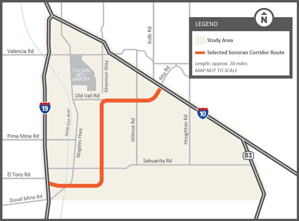
A Notice of Intent (NOI) to Prepare a Tier 2 EIS and DCR, which formally begins the study process, published in the Federal Register in late May 2025. The NOI documents, which are available below, identify the preliminary range of alternatives and project purpose and need.
The Tier 2 EIS and DCR are being prepared in accordance with the National Environmental Policy Act (NEPA) and other regulatory requirements. The environmental review, consultation and other action required by applicable Federal environmental laws for this project are being or have been carried out by ADOT pursuant to 23 USC 327 and a Memorandum of Understanding dated 06/25/24 and executed by FHWA and ADOT.
2025 Public Meeting Materials
A comment period to gather public input was held from May 28, 2025 through July 18, 2025. All comments and questions received during that period are documented in the public involvement summary. Public meetings were held in June 2025 to provide information about the current phase of the study and to seek input on the preliminary range of alternatives, as well as the preliminary project purpose and need.
Meetings were held on June 17, 2025 in Sahuarita and June 18, 2025 virtually.
Study Overview
The current Tier 2 study will build upon the Tier 1 Environmental Impact Statement (EIS) study, which selected a 2,000-foot-wide corridor route. The Tier 2 study will develop and evaluate a range of 400-foot-wide freeway alignment alternatives within the 2,000-foot corridor. The study will also evaluate a “no build” alternative and other design features and environmental impacts and mitigation. The study process will ultimately identify the Selected Alternative based on public, agency and tribal government input and technical analyses.
Study Goals
- Refine the purpose and need of the proposed project
- Develop and evaluate a range of 400-foot-wide freeway alignment alternatives within the 2,000-foot corridor, including a “No-Build” alternative
- Evaluate environmental considerations and proposed mitigation
- Develop design concepts and features, such as interchange locations and bridges
- Provide several opportunities for public and stakeholder input throughout the process
- Select a preferred freeway alternative, which would include the alignment, interchange locations and other design features
Ultimately the study will:
- Identify potential interchange locations and develop interchange design concepts
- Develop and circulate for public review and comment on a draft Tier 2 EIS and DCR that identifies the Preferred Build Alternative, which will be compared against the No Build alternative
- Prepare a final EIS and DCR document identifying the Selected Alternative
Purpose and Need
The Sonoran Corridor Study – Tier 1 EIS identified the following purpose and need for the new freeway. A new freeway would:
- Improve vehicle mobility and the transportation system
- Improve access to existing and future activity centers
- Reduce persistent traffic backups and road congestion
- Address existing and future high-growth areas
- Improve and shorten east-west freight movement to and from Mexico and southern Arizona
- Add a new, faster connection to Tucson International Airport
Study Process and Schedule
The Federal Highway Administration (FHWA), on behalf of ADOT, issued a NOI to prepare a Tier 2 EIS and DCR in late May 2025, which formally started the NEPA process.
During the current phase of the study, ADOT is seeking public, agency and tribal government input on the preliminary range of alternatives for the freeway alignment, the study preliminary purpose and need, or other relevant information for consideration in developing the Tier 2 Draft EIS.
As the study progresses, ADOT will further evaluate the preliminary range of alternatives (including the No-Build), confirm a reasonable range of alternatives, and will identify a Preferred Alternative based on engineering and environmental considerations, as well as agency, Tribal government and public input. A draft Tier 2 EIS and initial DCR will be circulated for public review and comment, which will compare the Preferred build alternative(s)against the No Build alternative. ADOT will hold public hearings to receive comments on the Draft EIS/Initial DCR and will provide other comment methods. At the conclusion of the study, ADOT anticipates the release of a Final EIS and DCR document addressing comments on the Draft EIS and will issue a Record of Decision (ROD) identifying a Selected Alternative. Funding must be identified to issue a ROD for the Sonoran Corridor EIS process and to move forward with the project design and/or right-of-way acquisition, if a build alternative is selected.
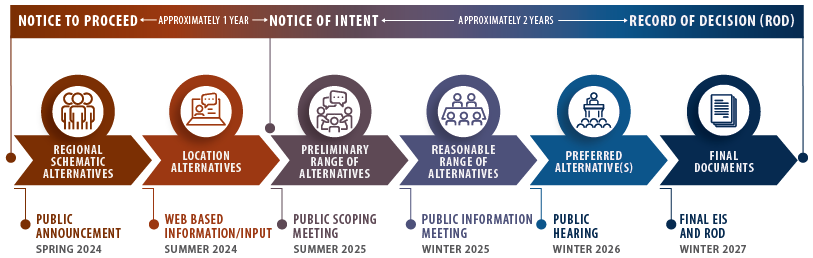
There is no timeline to construct the Sonoran Corridor, since it is not currently funded for design or construction.
Constraint Evaluation
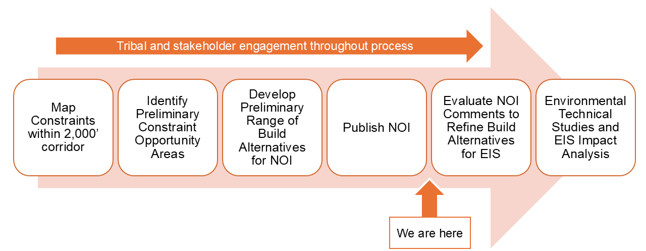
The alternatives development process began with identifying and mapping potential constraint areas within the Tier 2 Study Corridor to prepare a preliminary range of alternatives to be studied further in the EIS. Constraints include various environmental and engineering considerations to avoid where possible, and are listed below.
Constraints within Study Corridor
- Cultural Resources
- Section 4(f)
- Clean Water Act/Section 404
- Hazardous materials
- Biological resources
- Wildlife habitat and connectivity
- Social and economic considerations
- Noise considerations
- Drainage and floodplains
- Major utilities
- Terrain
- Existing transportation infrastructure and crossings (Tucson International Airport, Union Pacific Railroad, major roadways)
- Agency, Tribal government, stakeholder and public input
Click map image to enlarge
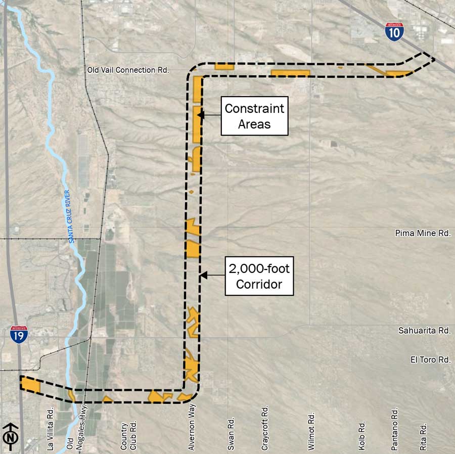
The Tier 2 study corridor was divided into three analysis segments and the known constraint information from the Tier 1 Study and preliminary Tier 2 data were mapped. Once the constraints and risks were mapped, opportunity areas with lower risk and fewer constraints were identified, which produced preliminary alignment options for each segment. An initial technical evaluation of engineering and environmental criteria was conducted and a subsequent review was conducted for how the preliminary segment alignment options could connect into feasible end-to-end preliminary alignment alternatives. ADOT will continue to work with agency, public and Tripal partners to further develop and refine the alternatives that will be evaluated in the EIS.
The process identified potential avoidance areas as well as opportunity areas that guided where preliminary alignment options could be placed. Each technical consideration was evaluated independently, and the results of evaluation from each segment were compared to develop preliminary conceptual alignments options that connect each segment and address geometric design criteria for the future facility.
Constraint Mapping Results
The process identified potential avoidance areas as well as opportunity areas that guided where preliminary alignment options could be placed. Each technical consideration was evaluated independently, and the results of evaluation from each segment were compared to develop conceptual alignments options that connect each segment and address geometric design criteria for the future facility. This step applied roadway geometric design standards to create logical and feasible preliminary end-to-end alignment options that avoid, or minimize impacts to, critical constraints and maximize the use of the areas. In areas where there were multiple preliminary constraints identified, ADOT examined the nature of the underlying constraints to identify a range of alignment alternatives that could potentially minimize impacts. This step resulted in a preliminary range of horizontal alignment options that were combined to create three preliminary end-to-end alternatives.
The constraint maps highlight areas where impacts should be evaluated further for avoidance or minimization efforts through the Tier 2 process.
Preliminary Range of Alternatives
Click map image to enlarge
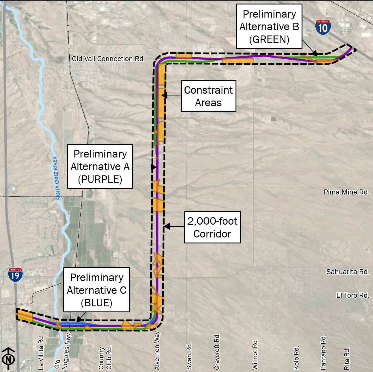
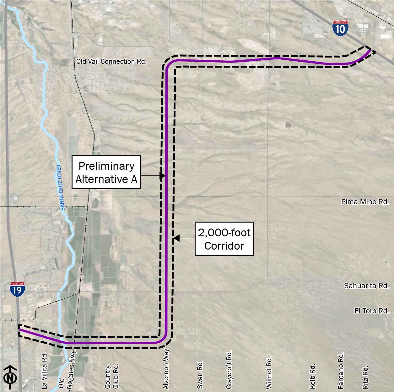
Preliminary Alternative A
Length: 20.53 miles
This alternative extends east from I-19 to the Alvernon Way alignment, centered within the Tier 2 Study Corridor, then travels north along the Alvernon Way alignment to approximately the Old Vail Road alignment, centered within the Tier 2 Study Corridor, then travels east along the Old Vail Road alignment, along the north edge of the Tier 2 Study Corridor, then ends at I-10, along the south edge of the Tier 2 Study Corridor.
Click map image to enlarge
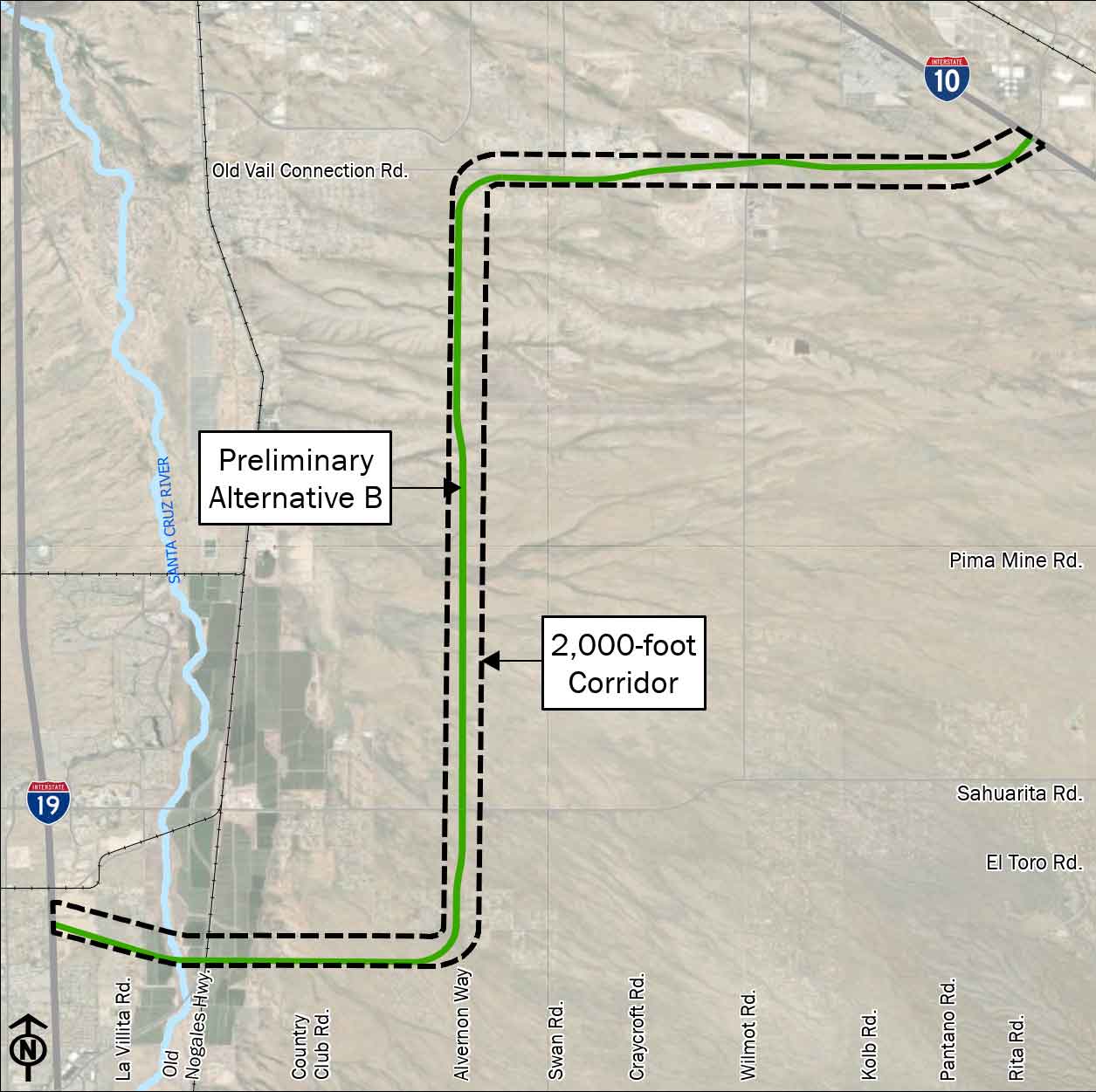
Preliminary Alternative B
Length: 20.40 miles
This alternative extends east from I-19 to the Alvernon Way alignment, along the south edge of the Tier 2 Study Corridor, then travels north along the Alvernon Way alignment to approximately the Old Vail Road alignment, centered within the Tier 2 Study Corridor, then travels east along the Old Vail Road alignment, along the north edge of the Tier 2 Study Corridor ending at I-10.
Click map image to enlarge
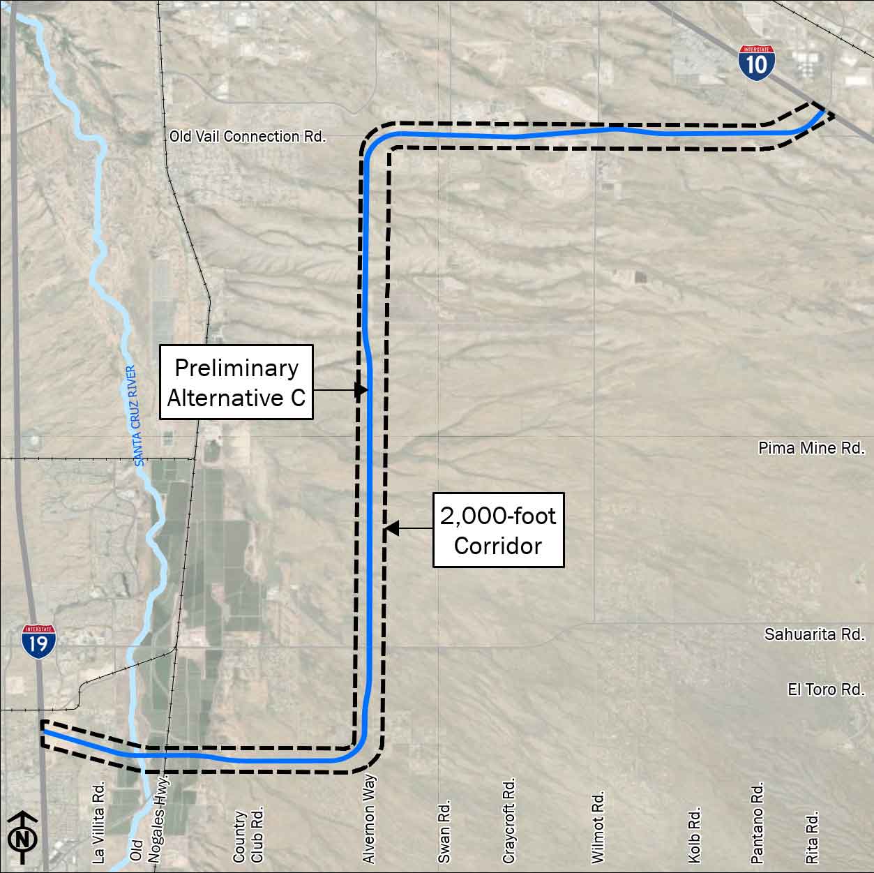
Preliminary Alternative C
Length: 20.38 miles
This alternative extends east from I-19 to the Alvernon Way alignment, along the south edge of the Tier 2 Study Corridor, then travels north along the Alvernon Way alignment to approximately the Old Vail Road alignment, centered within the Tier 2 Study Corridor, then travels east along the Old Vail Road alignment, along the north edge of the Tier 2 Study Corridor ending at I-10.
Click map image to enlarge
Preliminary Alternatives with Constraint Mapping
The preliminary alternatives are shown below in relation to the mapped constraints. The options are shown in Segments 1, 2 and 3 (from the west side of the selected corridor moving east) and how they would interact with the constraint mapping identified.
Segment 1 Preliminary Alternatives
The graphics below depict the current range of freeway alignment alternatives being considered for the west portion of the proposed corridor, along with the initial constraint areas identified in yellow. Preliminary Alternative options A (Purple), B (Green) and C (Blue) are shown.
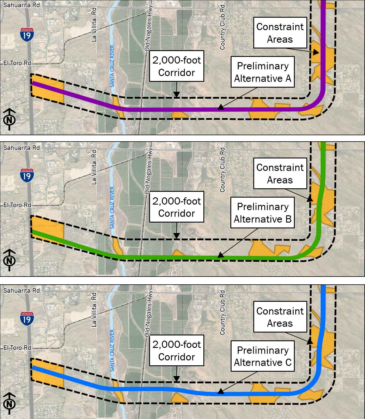
Preliminary Alternative A (Purple) is in the middle of the study corridor. Approaching Sahuarita Road, this alignment is adjacent to the existing Alvernon Way alignment.
Preliminary Alternative B (Green) is along the south side of the study corridor. This alternative provides a shorter crossing distance over the Santa Cruz River/Nogales Highway/Union Pacific Railroad, traverses the narrowest portion of the floodway and reduces impacts to initial constraint areas just west of the south elbow. At the south elbow, this alignment is centered between existing Palo Verde Road and Alvernon Way to balance initial constraints then transitions to be centered within the Tier 2 Study Corridor along the existing Alvernon Way alignment to allow for possible avoidance of initial constraint areas east of the Santa Cruz River. The alignment then transitions to be centered within the corridor. At the south elbow, like Preliminary Alternative B, this alignment is centered between existing Palo Verde Road and Alvernon Way to balance initial constraints, then transitions to be centered within the study corridor along the existing Alvernon Way alignment.
Segment 2 Preliminary Alternatives
The graphic below depicts the current range of freeway alignment alternatives being considered for the middle portion of the proposed corridor, along with the initial constraint areas highlighted in yellow. Preliminary Alternative options A (Purple), B (Green) and C (Blue) are shown.
Click image to enlarge
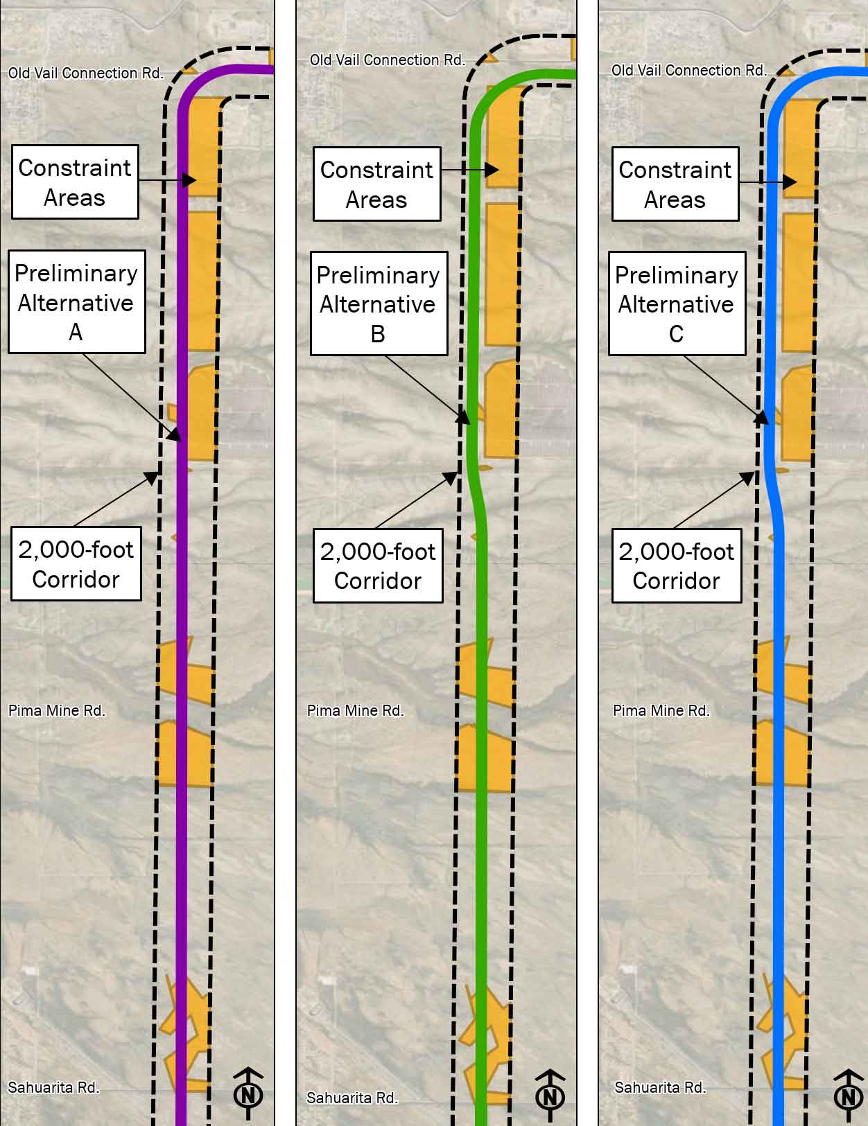
Preliminary Alternative A (Purple) is in the middle of the study corridor, along the existing Alvernon Way alignment approaching Old Vail Rd. At the north elbow, the alignment follows the existing Old Vail Road alignment.
Preliminary Alternative B (Green) is in the middle of the study corridor, then transitions to the west side of the Alvernon Way alignment approaching Old Vail Road to reduce potential impact to identified initial constraint areas. At the north elbow, the alignment is in the south side of the study corridor to avoid and minimize potential impact to initial constraint areas
Preliminary Alternative C (Blue) is in the middle of the Tier 2 Study Corridor, then transitions to the west side of the Alvernon Way alignment approaching Old Vail Road to reduce potential impact to identified initial constraint areas. At the north elbow, the alignment is on the north side of the study corridor to follow the existing Old Vail Road alignment.
Segment 3 Preliminary Alternatives
The graphic to the below depicts the current range of alignment alternatives being considered for the east portion of the proposed corridor, along with initial constraint areas highlighted in yellow. Preliminary Alternative options A (Purple), B (Green) and C (Blue) are shown.
Click image to enlarge
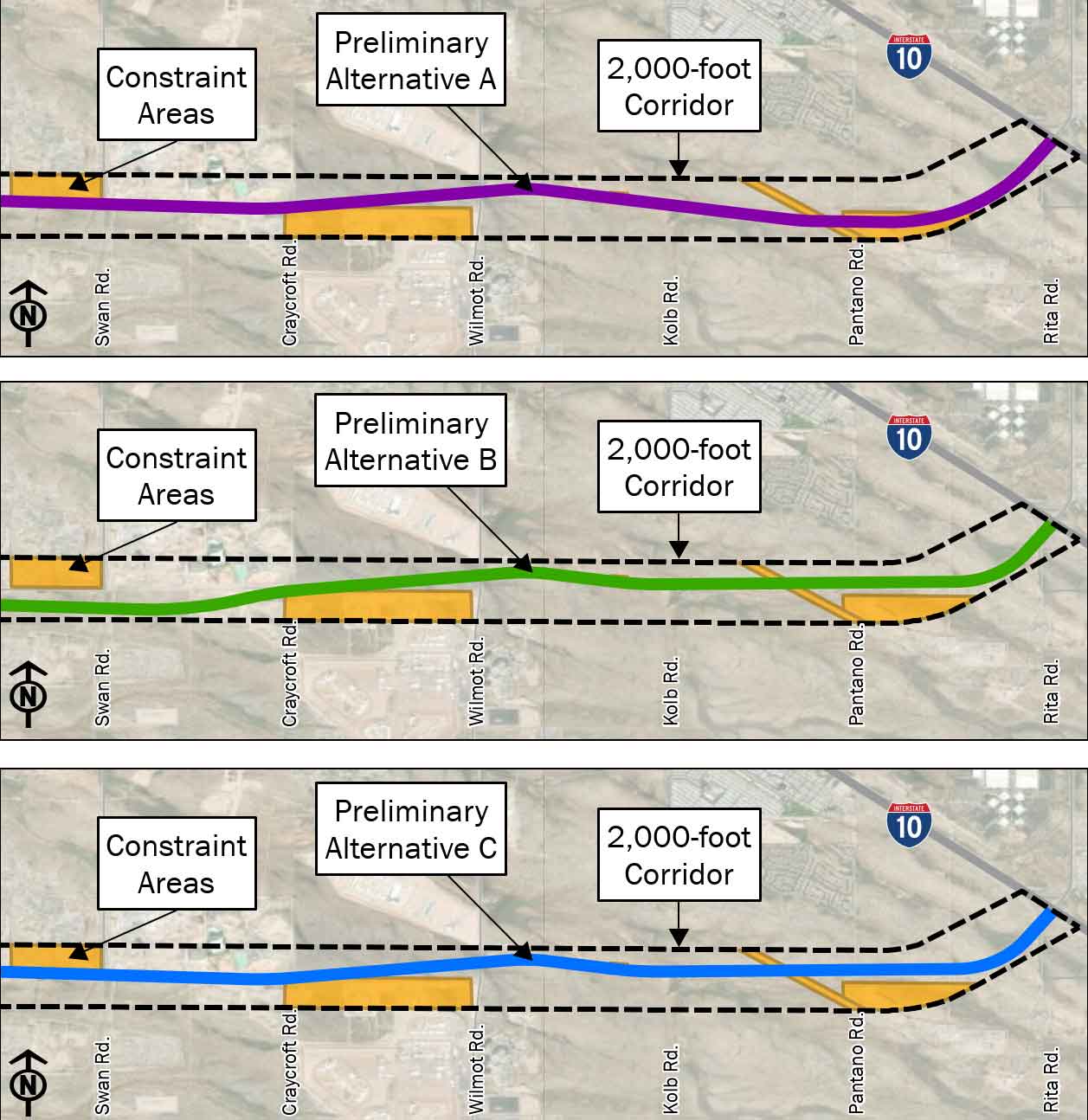
Preliminary Alternative A (Purple) is in the middle of the study corridor, then transitions to the north side of the corridor to minimize potential impacts to constraints. Approaching I-10 the alignment transitions to the south side of the corridor to provide one option for connection to I-10.
Preliminary Alternative B (Green) is on the south side of the study corridor, then transitions to the north side of the corridor to minimize potential impacts to initial constraints. Approaching I-10, it transitions to avoid impacts to constraints, providing another option for connection to I-10.
Preliminary Alternative C (Blue) is in the middle of the study corridor, then transitions to the north side of the corridor to minimize potential impacts to constraints. Approaching I-10 transitions to avoid impacts to initial constraints, providing a similar connection option to I-10 as Preliminary Alternative B.
No Build Alternative
The NEPA process requires evaluation of a No-Build Alternative to serve as the baseline to which preliminary alternatives are compared. The No-Build alternative includes the existing regional transportation system plus the projects the region has already committed to fund.
The No-Build Alternative can include other programmed activities already in the State Transportation Improvement Program (STIP) or Transportation Improvement Program (TIP), other nearby projects that have been constructed or approved, or long-term operations and maintenance activities that would occur even if the No-Build Alternative is selected.
As part of the Tier 2 EIS, ADOT will be evaluating the No-Build Alternative and will compare this alternative against the range of build alternatives presented in the EIS.
Sonoran Corridor Tier 1 Environmental Impact Statement and Record of Decision
In May 2017, the Federal Highway Administration (FHWA), in coordination with the Arizona Department of Transportation (ADOT), issued the Notice of Intent that started the environmental review process for the Sonoran Corridor, a potential new corridor route that would connect Interstate 19 and Interstate 10 south of Tucson International Airport.
The Final Tier 1 EIS and Record of Decision (ROD), released November 5, 2021, identifies the selected corridor route, which stretches between Interstate 19 (I-19) and Interstate 10 (I-10), south of the Tucson International Airport in Pima County.
Click here to view the Tier 1 Preferred Corridor Alternative
As part of the NEPA process, ADOT and the FHWA engaged stakeholder agencies, organizations and the public throughout the study process.
Final Tier 1 EIS and ROD documents
Contact Us

Your input is important. ADOT welcomes your questions and comments on this study through the methods outlined below. Thank You!
Phone: ADOT Bilingual Project Information Line 855.712.8530
Email: [email protected]
Mail: ADOT Sonoran Corridor Study Team, 2540 N. Tucson Boulevard, Tucson, AZ 85716
If you would like to be notified when updates are issued, please subscribe for email updates.