pima county

Cienega Creek Bridge: Arizona's longest open-spandrel bridge

Cienega Creek Bridge: Arizona's longest open-spandrel bridge

SR24-1

Cienega Creek Bridge: Arizona's longest open-spandrel bridge

Cienega Creek Bridge: Arizona's longest open-spandrel bridge

Kathy Cline / ADOT Communications
June 1, 2022

"The spandrel of an arch bridge is the area between the arch ring and the roadway. ... Open-spandrel arches have columns resting on the arch ring that support floor beams, which in turn carry the roadway."

Cienega Creek Bridge Pima County AZ

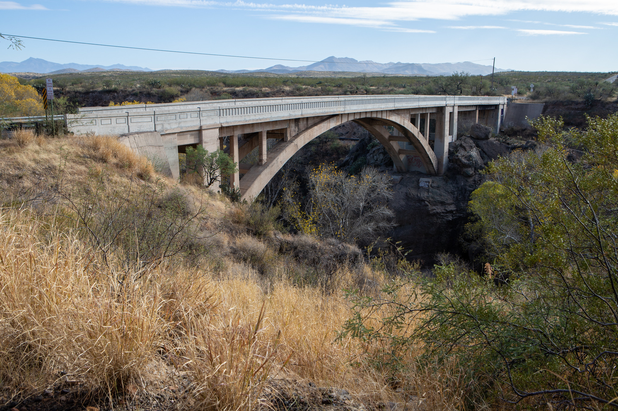
We know what you're thinking: Uh, OK, what does that mean in plain English? Let's show you an example: Cienega Creek Bridge in Pima County.

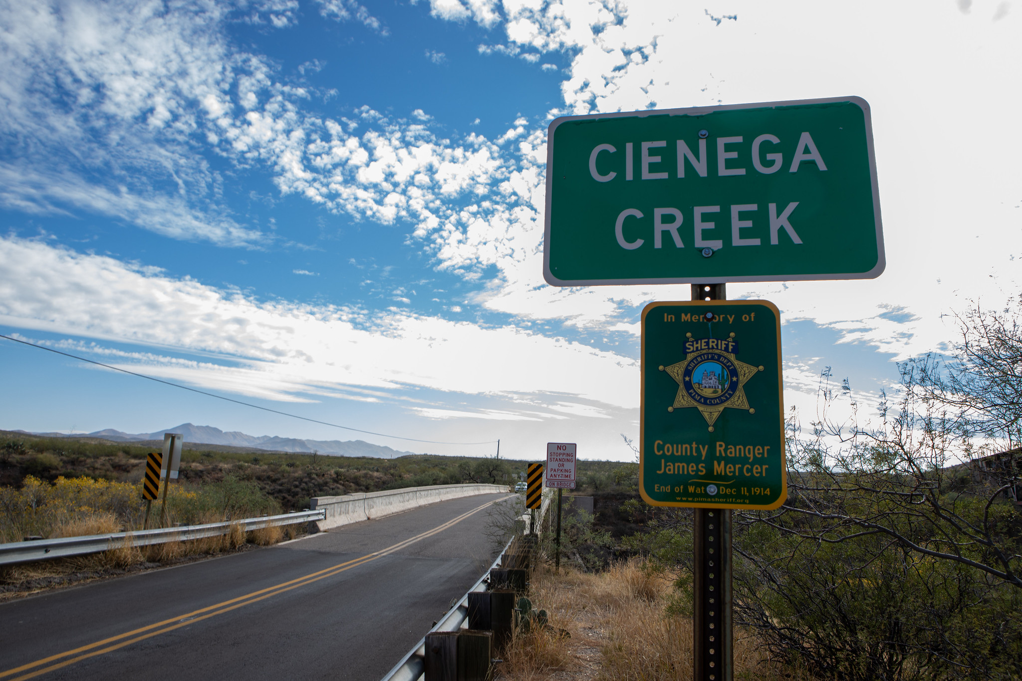
Known as Arizona's longest open-spandrel bridge, the Arizona Highway Department -- a precursor to the Arizona Department of Transportation -- began construction of Cienega Creek Bridge began in 1920 as part of the new Borderland Highway (US 80) across southern Arizona. The bridge is located a few miles east of Vail, Ariz., and near a railroad.

Construction was finished in 1921. At 146 feet, Cienega Creek Bridge's open-spandrel arch is comprised of two tapered ribs that are anchored in concrete foundations with spread footings. 

The bridge was part of U.S. 80 from 1926 to 1955 and was put on the National Register of Historic Places in 1988. It is no longer a state highway and, today, carries local traffic on Marsh Station Road. 

ADOT Selects final Sonoran Corridor route in Pima County

ADOT Selects final Sonoran Corridor route in Pima County

I-17 101 traffic interchange

ADOT Selects final Sonoran Corridor route in Pima County

ADOT Selects final Sonoran Corridor route in Pima County

November 5, 2021

Following several years of study, technical analysis and input from communities and stakeholders, the Arizona Department of Transportation has selected a final 20.47 mile corridor through Pima County.

Following several years of study, technical analysis and input from communities and stakeholders, the Arizona Department of Transportation has selected a final 20.47 mile corridor through Pima County. The Final Tier 1 Environmental Impact Statement (EIS) and Record of Decision (ROD), which was released Friday, Nov. 5, identifies the selected corridor, which stretches between Interstates 19 and 10, south of the Tucson International Airport in Pima County. 

A continuous, access-controlled transportation corridor between I-19 and I-10 would:

  • Improve access to future activity centers
  • Improve regional mobility
  • Improve connectivity
  • Integrate the region’s transportation network
  • Address existing and future population and economic growth
  • Provide an alternative to avoid congestion on I-10 and I-19 

The combined Tier 1 Final EIS/ROD, along with its supporting documentation, is available on the study’s website at azdot.gov/sonorancorridor. In addition, hard copies of the combined Tier 1 Final EIS/ROD document are also available for viewing at the following locations during normal business hours: 

Southcentral District Office - 1221 S. 2nd St. Tucson. Please call to make an appointment. Phone: 520.388.4200

Joel D. Valdez Main Library, 101 N. Stone Ave. Tucson, AZ 85701 520.594.5500

Joyner-Green Valley Library, 601 N. La Canada Dr. Green Valley. Phone:  520.594.5295

Sahuarita Town Clerk’s Office, 375 W. Sahuarita Center Way. Phone: 520.822-8801

Subsequent Tier 2 environmental and engineering studies would need to be conducted as part of the NEPA process to further refine the selected 1,500-foot Sonoran Corridor to identify a recommended 400-foot freeway alignment and identify planned interchange locations and other project elements. 

The Final Tier 1 EIS includes a phased implementation plan with preliminary recommendations for how the Sonoran Corridor could move forward into Tier 2 studies. The phased implementation plan includes smaller segments of the selected corridor alternative that may advance as separate, independent projects. These studies, which are not yet funded, would include additional analysis and more opportunities for public review and comment.

For more information about the Sonoran Corridor Study or to view the project fact sheet, please visit  azdot.gov/sonorancorridor

General comments or questions about the study can be submitted to ADOT through the following methods:

Online: azdot.gov/sonorancorridor

Email: [email protected]

Phone: 1.855.712.8530

Mail: c/o ADOT Communications – Sonoran Corridor, 1221 S. 2nd Ave. Tucson, AZ 85713