SR 366

A bridge to better picnicking on Mount Graham

A bridge to better picnicking on Mount Graham

A bridge to better picnicking on Mount Graham

A bridge to better picnicking on Mount Graham

August 11, 2017

By Tom Herrmann / ADOT Communications

Back in 1935, a little bridge at Wet Canyon helped open up the beauty of Arizona’s Mount Graham for hiking, camping, picnicking and all sorts of outdoor activities on Graham County’s tallest peak.

Lately, though, the old bridge has been as helpful to picnickers as Yogi Bear’s fondness for pic-i-nic baskets.

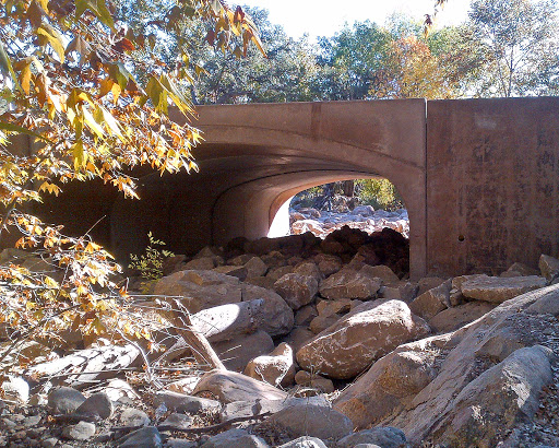
Monsoon rains of the past two weeks washed debris off the mountain and into the drainage at Wet Canyon. Some of it is from the recent Frye Fire, but it’s also from a fire that occurred back in 2004. All of the debris was too much for the 80-year-old bridge, which had only a small opening for water to pass through. The result was flooding that closed some recreational areas and washed away picnic tables from the Wet Canyon Picnic Area.

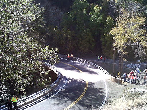
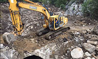
Arizona Department of Transportation crews had already built a new bridge at this spot on Swift Trail (State Route 366). With cooperation from the U.S. Forest Service and other agencies, ADOT crews removed the old bridge in just two days this week.

Brian Jevas, assistant district engineer for ADOT’s Southeast District, shot the before, during and after images above while standing on the new bridge, which is higher and has plenty of room for water and flood debris to get by.

SR 366 remains closed indefinitely at Ladybug Saddle because of storm damage and concerns about flash flooding. Drivers should watch for ADOT and U.S. Forest Service crews in the area.

Recreational areas at Noon Creek, Angle Orchard, Wet Canyon and Turkey Flat are open thanks to some hard-working folks who did fast work with the old bridge this week. Enjoy.

State Route 366 on Mount Graham closes for winter

State Route 366 on Mount Graham closes for winter

I-17 101 traffic interchange

State Route 366 on Mount Graham closes for winter

State Route 366 on Mount Graham closes for winter

November 14, 2016

PHOENIX ‒ The upper, unpaved portion of State Route 366, which ascends Mount Graham in the Pinaleño Mountains southwest of Safford, closed Monday, Nov. 14, for the winter, according to the Arizona Department of Transportation.

The closure is in effect through April 15.

SR 366, also known as the Swift Trail, begins about five miles south of Safford off US 191.

The highway is blocked about one-half mile past the Coronado National Forest’s Shannon Campground, at the end of the pavement.

Motorized vehicles aren’t allowed on SR 366 past the locked gate, but hikers, mountain bikers and cross-country skiers can still use the area.

ADOT will close lower portions of SR 366 as needed to clear snow.

Construction wraps up on SR 366 improvements

Construction wraps up on SR 366 improvements

Construction wraps up on SR 366 improvements

Construction wraps up on SR 366 improvements

November 7, 2012

Sometimes seemingly minor road upgrades lead to big-time improvements for drivers…

Take the Swift Trail project in Graham County, for example. Crews currently are wrapping up work on the project that sits along SR 366. Construction began in February 2012 and included:

  • Replacing pipe drainage culverts at Noon Creek with a single concrete archway 
  • Constructing a new highway bridge at Wet Canyon 

The scope may not sound as massive as some of the projects we’ve blogged about, but all the work being done will make a difference to drivers and here’s why…

A new arch replaces drainage culverts at Noon Creek

The old highway bridge at Wet Canyon was narrower and had a tight curve that could be difficult to maneuver for larger vehicles.

The new bridge is wider, has an easier turn and improved sight-lines for motorists. (By the way, the old bridge is still there. It’s a historic structure and was preserved for pedestrians.)

The drainage improvements at Noon Creek replaced two pipe culverts with one archway to reduce the potential for flooding – the new arch is much larger and will be able to handle higher water levels.

A look at the partnership involved on the Swift Trail Project
The project was constructed under the Federal Highway Administration’s Central Federal Lands Highway Division, in cooperation with ADOT and the U.S. Forest Service. FHWA funded the project with money allocated for routes that lead to federal lands – in this case, the Coronado National Forest.

wet-canyon

The new bridge at Wet Canyon.

What’s next?
The project is essentially complete; in fact, representatives from ADOT and FHWA held a ribbon cutting ceremony earlier this month (see video above).

There is still a retaining wall that needs to be extended at the Wet Canyon site and that work is expected to be complete by the middle of this month. Construction at Noon Creek is finished.

More on the project can be found on the ADOT website.

ADOT closes certain state routes for winter months

ADOT closes certain state routes for winter months

ADOT closes certain state routes for winter months

ADOT closes certain state routes for winter months

November 30, 2011

Taken early this year on I-40 near Flagstaff, this photo shows some serious snowfall. Other Arizona routes that receive little traffic and heavy snowfall are closed during the winter months.

Snow-covered, icy highways get swift attention from ADOT crews each winter, but some routes face factors so severe, that completely closing the road down for a few months is the best option.

A handful of state routes are annually shut down because they’re located in areas where HEAVY snowfall is common. These routes typically see little traffic – so it makes sense for ADOT to use its resources to keep more heavily traveled highways open.

When ADOT closes a road for the winter, maintenance crews will set up barricades at the closure points and then drive the roads to make sure no vehicles are in the closed sections.

So far, a few routes have already been closed, or are scheduled to close within a few weeks …

A portion of SR 366, also known as “The Swift Trail,” was closed on Nov. 15. This is the scenic highway that leads to Mount Graham – the closure begins at the end of the paved highway, just beyond the turnoff to Shannon Campground. ADOT may need to close the highway at lower elevations as necessary to allow for snow removal (this highway is too narrow to allow traffic to pass the snowplow). The Swift Trail should open up again in mind-April, unless conditions require it to be closed longer.

SR 67 – between Jacob Lake (US 89A) and the North Rim of the Grand Canyon – closed on Nov. 28. This portion of the route won’t be cleared of snow during the winter since the visitor accommodations at the North Rim are closed. Expect this road to re-open around mid-May.

SR 473 to Hawley Lake is slated to close Nov. 30.

SR 261 – between Big Lake and five miles south of SR 260 – is scheduled to close on Dec. 19.

A five-mile segment of SR 261 from the junction of SR 260 south toward Big Lake may be left open until Jan. 16, depending on the amount of snowfall.

SR 273 between Sunrise Park and Big Lake will close Dec. 19. The segment of SR 273 between SR 260 and Sunrise Park will remain open to provide access to the ski area.

It’s important for motorists to drive with caution as they encounter winter conditions. Check out ADOT’s “Know Snow” web page for maps and tools to assist you this season. You can also stay up-to-date with the latest highway conditions by visiting az511.gov or by calling 511.