Throwback Thursday: The rocky road to Prescott
Throwback Thursday: The rocky road to Prescott
Going uphill is a fact of driving some Arizona highways, especially as you go from the Sonoran desert in the south up to the mountains or onto the Colorado Plateau. From the earliest days of transportation, that has always been the case.
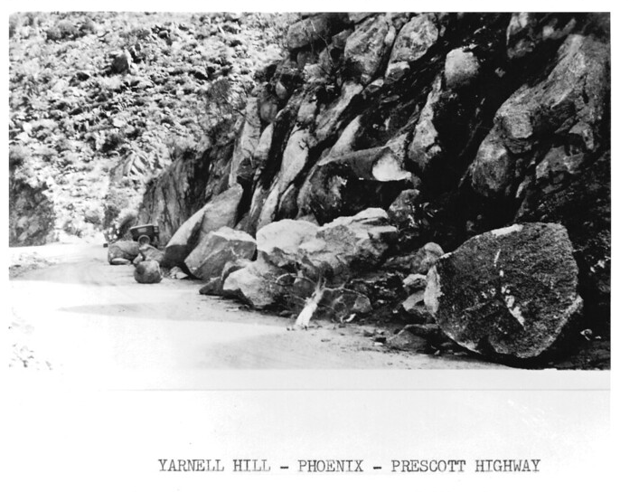
Which brings us to this excellent photo from 1932 we found in our archives. As the caption tells us, this shot of rocks beside – and on – the road is Yarnell Hill along the Phoenix-to-Prescott Highway.
Anyone who has driven from Congress to Yarnell, or vice versa, is familiar with this particular portion of what is now State Route 89. If you take it today, you ascend roughly 1,000 feet in a little under 4 miles. And that's the modern road with today's vehicles. Imagine doing it on a graded dirt road in the car you see in the background. We also don't envy the crews that had to remove those hefty boulders from the road without the benefits of a front loader.
And how about that Phoenix-to-Prescott Highway? We told you about this highway in another blog post, where it was one of the original north-south roads envisioned by Arizona's territorial government in 1909. That route originally was planned to run directly south from Prescott to Phoenix, which includes some notoriously steep terrain. By 1917, the route between Prescott and Wickenburg, and then on to Phoenix, became the better option. That's the route US 89 would take in the 1920s as it climbed from Nogales to the Utah state line, and it's still the way State Route 89 will get you to Prescott.
Times may have changed, but rock removal along state highways remains a concern for ADOT. In March 2020, crews were busy clearing boulders from along State Route 89A near Jerome and – you guessed it – on State Route 89 near Yarnell.