Alert icon

Drivers traveling on SR 347 should plan for lane restrictions Sept. 10 - 18

Learn more

Drivers should plan for extra travel time through the project corridor during overnight and weekend work

ADOT advises drivers to use caution and be prepared to slow down, follow the posted speed limit and merge safely when approaching and traveling through all work zones. Drivers should allow for extra travel time and watch for construction personnel and equipment as work progresses in the State Route 347 Improvement Project corridor.

    Weeknight Work

  1. Thursday, Sept. 10: Northbound SR 347 will be narrowed to one lane from Casa Blanca Road to Mammoth Way from 8 p.m. Thursday, Sept. 10, to 4 a.m. Friday, Sept. 11, for paving.

  2. Monday, Sept. 14: Northbound SR 347 will be narrowed to one lane from Casa Blanca Road to Mammoth Way nightly from 8 p.m. - 4 a.m. beginning Monday, Sept. 14, through Wednesday, Sept. 16, for geotechnical work. 

  3. Monday, Sept. 14: Southbound SR 347 will be narrowed to one lane from Mammoth Way to Casa Blanca Road nightly from 8 p.m. - 5 a.m. beginning Monday, Sept. 14, through Wednesday, Sept. 16, for geotechnical work. 

  4. Thursday, Sept. 17: Northbound SR 347 will be narrowed to one lane from Casa Blanca Road to Mammoth Way from 8 p.m. Thursday, Sept. 17, to 4 a.m. Friday, Sept. 18, for paving. 

  5. Weekend Work

  6. Starting Friday evening, Sept. 11: Northbound SR 347 will be narrowed to one lane from Casa Blanca Road to Mammoth Way 24/7 beginning 8 p.m. Friday, Sept. 11, to 4 a.m. Monday, Sept. 14, for paving. 

  7. Starting Friday evening, Sept. 11: Southbound SR 347 will be narrowed to one lane from Mammoth Way to Casa Blanca Road 24/7 beginning 8 p.m. Friday, Sept. 11, to 5 a.m. Monday, Sept. 14, for paving. 

Project Lookahead

Daytime and overnight lane restrictions will be in place the weekends of Sept. 19 and Sept. 26. More detailed information will be provided as the construction schedule is finalized.  
The project schedule is subject to change due to weather or other unforeseen circumstances.

To sign up for project updates and traffic alerts to stay in the know, please visit the project website at azdot.gov/sr347.

Real-time highway conditions are available on ADOT’s Arizona Traveler Information site at AZ511.gov, the AZ511 app (download for Apple or Android devices) or by calling 511. Drivers can set their own alerts on the AZ511 app in order to be notified when there is an incident, lane restriction or closure.

SR 347 Improvement Project Detour Map Drivers traveling on SR 347 should plan for lane restrictions Sept. 10 - 18

Show less

SR 347 Improvement Project

SR 347 Improvement Project

Contents

SR 347 Web Banner Graphic

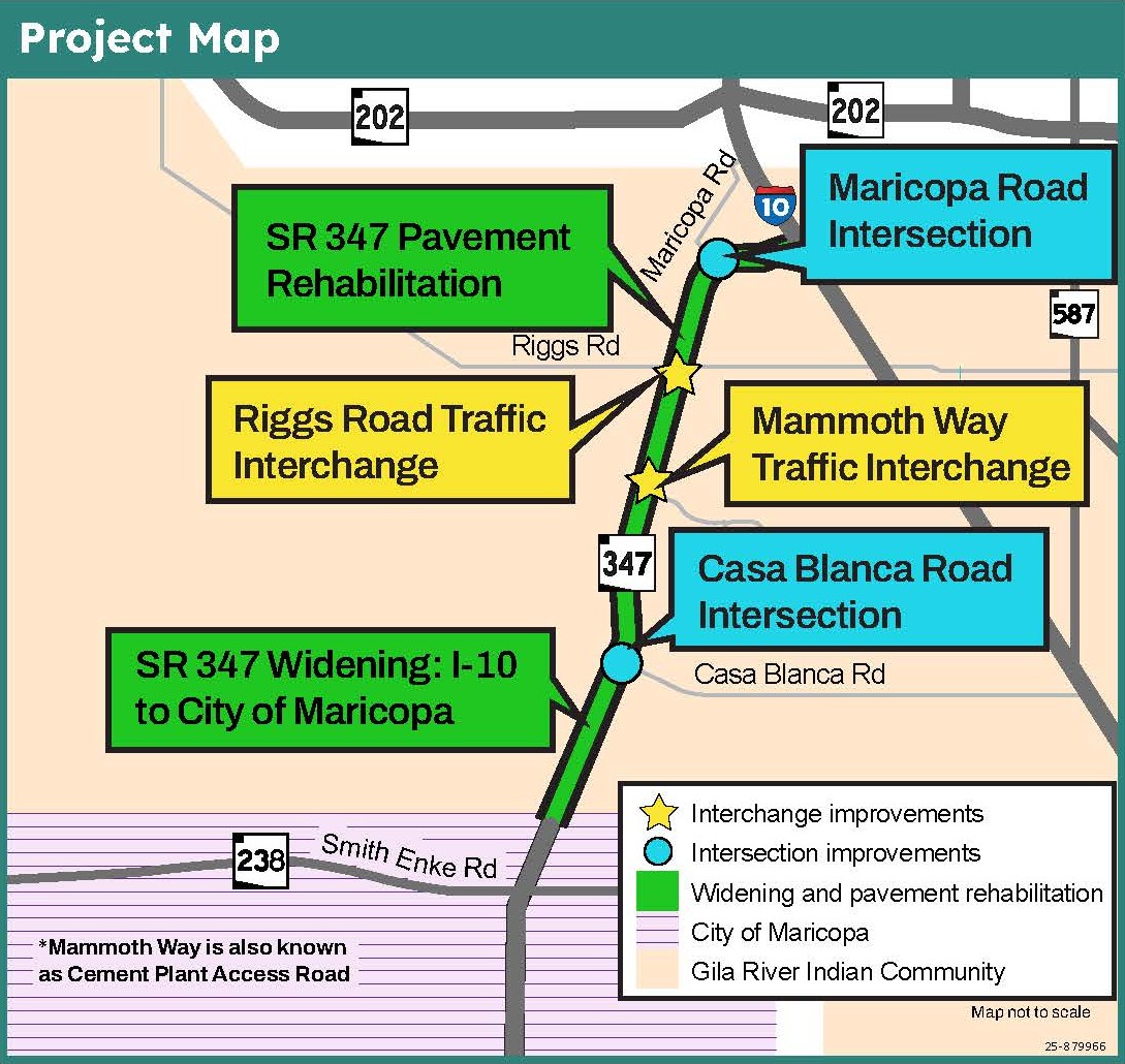
The State Route 347 Improvement Project will improve a 14-mile section of SR 347 between Interstate 10 and the City of Maricopa. This project corridor runs through Maricopa and Pinal counties and is primarily located within the Gila River Indian Community. Construction is currently underway and is slated for completion in late 2029.

Planned Improvements

The planned improvements include:

  • Adding one lane in each direction along SR 347 from I-10 to the City of Maricopa
  • Constructing a concrete median barrier to physically separate the directions of travel
  • Rehabilitating the existing pavement along that same 14-mile stretch of roadway
  • Constructing new grade-separated interchanges at Riggs Road and Mammoth Way
  • Adding turn lanes and other intersection improvements at Casa Blanca Road and Maricopa Road

Once complete, the SR 347 Improvement Project will provide added capacity, help alleviate congestion, and improve safety and traffic flow along this busy stretch of roadway that drivers depend on every day.

Project Map

A project area map depicting the SR 347 corridor improvements, including pavement, widening, intersection improvements and a new interchange.

Click Map to Enlarge

Project Schedule

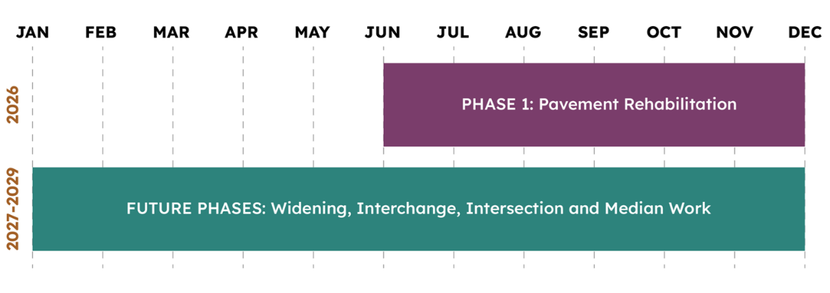
Phase 1, pavement rehabilitation, is currently underway. Additional phasing information will be available before the end of the year.

Phase 1 pavement rehabilitation is scheduled from July through December 2026. Future phases, including widening, interchange construction, intersection improvements, and median work, are scheduled across 2027 and 2029.

Traffic Management

  • Peak Travel Times – Two lanes will be maintained in each direction during weekday commute hours.
  • Work Hours – Most lane restrictions will be conducted overnight and on weekends.
  • Work Zone Safety – Speed limits are reduced to 55 mph throughout the entire 14-mile project corridor, and 45 mph in work zones.

Traffic Management Example Video

Info Icon

Stay Informed

  • Subscribe to receive project updates and traffic alerts.
  • Call the ADOT Project Information Line at 855.712.8530.
  • Submit a question or comment to [email protected].
  • Real-time highway conditions are available on ADOT’s Arizona Traveler Information site at AZ511.gov, the az511 app (download for Apple or Android devices) or by calling 511. Drivers can set their own alerts on the AZ511 app in order to be notified when there is an incident, lane restriction or closure.

Newsletter Sign Up