ADOT

Highway hero rescues, adopts stray dog

Highway hero rescues, adopts stray dog

SR24-1

Highway hero rescues, adopts stray dog

Highway hero rescues, adopts stray dog

By David Woodfill / ADOT Communications
July 16, 2024
Two people pose for a picture with a dog.

When Rich Dimaio, a member of ADOT’s Incident Response Team, sponsored by GEICO, suited up for work the morning of Tuesday, April 30, he didn’t expect he’d come home with new member of his family

Going about his usual morning routine, Dimaio received a call on his radio from dispatchers to respond to an incident on Interstate-17 near Thomas Road in Phoenix.

There, an Arizona Department of Public Safety trooper was pulled over to the side of the highway, trying to catch an agitated female German Shepherd that had been darting in and out of traffic.

“I was way out,” he said. “I didn’t expect to get there in time. Typically these animals don’t make it. It’s pretty rare.”

When Dimaio arrived on scene, all traffic had stopped.

“Just imagine at 6 in the morning, 7 in the morning, how much traffic there was,” he said.

Rich just happened to be pulling up when his dispatchers radio’d that  the dog was running his way. 

“I went to get her with the catch pole and she ducked it and took off.”

After a lot of scrambling, Dimaio and the trooper eventually caught the dog and Dimaio took her to Maricopa County Animal Care & Control.

“I could just see the fear that she had,” he said. “She had nobody.”

“Her eyes just melted me,” he added. “I just told her at the time, ‘I promise you if nobody claims you, I’ll take you home.’”

About a week went before Dimaio got a call from animal control officials. They said no one had claimed the dog and they wanted to know if he still wanted to adopt her.

Dimaio didn’t hesitate.

“I said, ‘Absolutely.’”

Today, the 4-year-old German Shepherd, who has been named “Freya” by Rich and his wife Florame, is a new dog. She’s put on weight and a minor injury she had to her leg has healed. 

The timid pooch took a while to come out of her shell, but she’s settled in nicely with  the Dimaios.

“Today I was blown away,” he said. “She was chasing the ball.”

Rich said Freya is very food-motivated and her favorite treats are Costco chicken, which he gives to her without the skin, and peanut butter snacks.

Freya’s still learning the rules of the house, including staying off of the beds. Still Rich admitted when Florame isn’t home, he occasionally lets her snuggle up with him there for pets and belly rubs.

“I can’t say no to her,” he said.

ADOT project adding two Loop 303 interchanges wins regional award

ADOT project adding two Loop 303 interchanges wins regional award

I-17 101 traffic interchange

ADOT project adding two Loop 303 interchanges wins regional award

ADOT project adding two Loop 303 interchanges wins regional award

July 15, 2024

America’s Transportation Awards cites community development benefits

PHOENIX – A recent Arizona Department of Transportation project that constructed Loop 303 interchanges at 43rd and 51st avenues near Interstate 17 is a winner in the 2024 America’s Transportation Awards competition that includes a focus on community development.

The $70 million Loop 303 project earned a West Region award in the “Quality of Life/Community Development, Medium Project” category in the national competition among state departments of transportation. The competition is sponsored by AASHTO, an association representing highway and transportation departments nationwide, as well as AAA and the U.S. Chamber of Commerce.

ADOT partnered with the Maricopa Association of Governments (MAG), the regional transportation planning agency, and city of Phoenix to accelerate construction of the Loop 303 bridges and ramps to address current and future traffic growth near the Taiwan Semiconductor Manufacturing Co. plant in the north Valley. The interchanges were completed in September 2023, several years sooner than originally planned.

“This project is an example of great teamwork and cooperation among partnering organizations,” said ADOT’s Central District Administrator Randy Everett. “It took a lot of hard work by staff at MAG, city of Phoenix, ADOT and the contractor, Fisher Sand and Gravel, to deliver this project on the accelerated schedule.”

The award was presented this week at the annual meeting of WASHTO, which represents departments of transportation in the West.

Construction of new Loop 303 interchanges at 43rd and 51st avenues was funded through the dedicated Proposition 400 half-cent sales tax approved by Maricopa County voters in 2004. The project is part of the Phoenix area’s Regional Strategic Transportation Infrastructure Investment Plan managed by MAG.

The new interchanges were designed to help manage future transportation needs in the area, support the Phoenix area’s growing semiconductor footprint and its supply chain, and allow for community development, including businesses and services. 

ADOT manages the construction and maintenance of nearly 7,000 miles of state highways, including Phoenix-area freeways. Project information is available at azdot.gov/projects


Over 50 years of dust storm safety at ADOT

Over 50 years of dust storm safety at ADOT

SR24-1

Over 50 years of dust storm safety at ADOT

Over 50 years of dust storm safety at ADOT

By Kelsey Mo / ADOT Communications
July 11, 2024
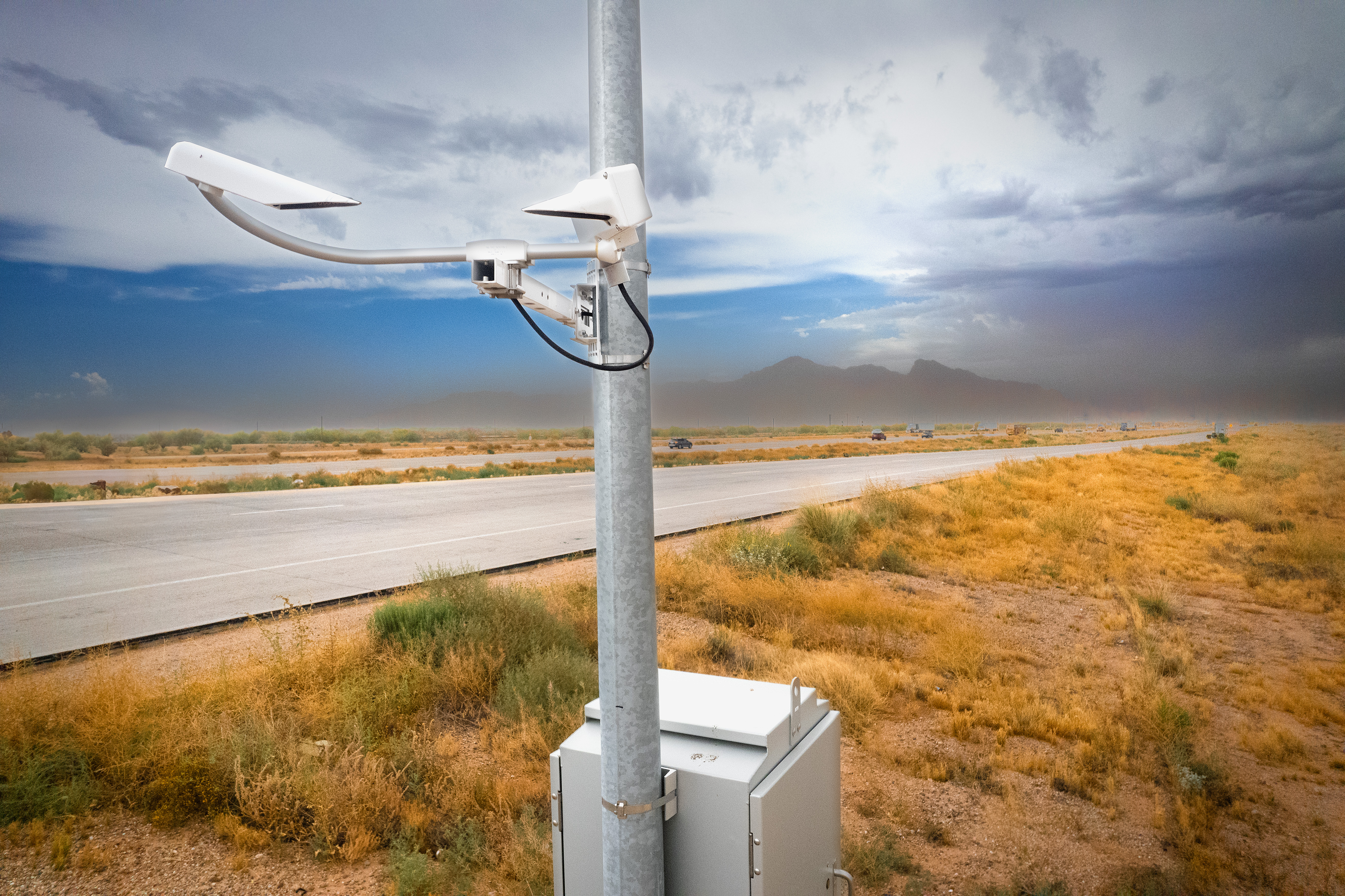
Dust sensors along a rural highway.

When monsoon season comes around, most Arizonans are familiar with the thunderstorms and dust storms that can cause dangerous driving conditions.

At the Arizona Department of Transportation, we’ve been working on keeping motorists safe on the highways in areas prone to blowing dust for more than 50 years.

Between 1972 and 1973, ADOT implemented a dust warning system along 81 miles of Interstate 10 and Interstate 8 near Casa Grande. The 40 message signs could rotate between different preset messages depending on weather conditions: GUSTY WINDS, USE CAUTION and BLOWING DUST, REDUCE SPEED. In clear conditions, the signs would display information about route designation. The message signs were operated by the Arizona Department of Public Safety, whose dispatchers could change the signs using radio signals.


Later, in the summer of 1976, these signs were updated to show a “dust storm alert.” According to archive photos, motorists could tune to Phoenix radio stations KOY (550AM), KTAR (620AM) and KJJJ (910AM) for advisories about what actions to take during a dust storm when the alert was displayed.

That same year, the agency also distributed posters that explained the actions to take during dust storms and how the changeable message signs along stretches of I-8 and I-10 worked. Those posters were put up at rest stops throughout central and southern Arizona, including at the Sacaton Rest Area on I-10. Pamphlets were also distributed to motorists at ports of entry, Motor Vehicle Division offices, AAA offices and other locations.  


Today, ADOT has a first-of-its-kind dust detection system located along a 10-mile corridor of I-10 between Eloy and Picacho Peak. There are 13 visibility sensors along the highway that detect the amount of dust particles in the air. When the sensors indicate that dust particles are reducing visibility, variable speed limit signs will reduce the speed limit from 75 mph to as low as 35 mph. 

This system has been operational since 2020 and has proven to be reliable. The sensors have successfully detected blowing dust and reduced speed limits on the electronic signs when dust drops visibility, and drivers do slow down. 

This stretch of the highway near Picacho Peak where the current dust detection system is located also used to have the original changeable message signs from the 1970s. So, ADOT has been improving on strategies with evolving technologies to help keep drivers safe in low-visibility conditions for decades.


And even today, you’ll find new posters at rest areas across the state, urging drivers to follow the Pull Aside, Stay Alive tips when encountering dust storms.

The “Pull Aside, Stay Alive” tips were developed by ADOT in collaboration with the Arizona Department of Public Safety and National Weather Service. If a dust storm is approaching, do not drive into it. But if you encounter low-visibility blowing dust and aren’t able to exit the highway, remember to: 

  • Check traffic around you and begin slowing down. 
  • Pull off as far right as you can and exit the highway before visibility becomes poor. 
  • Turn off all vehicle lights, including flashers. This is to prevent someone in a vehicle behind you using your lights as a beacon, possibly crashing into you. 
  • Set your emergency brake and take your foot off the brake. 
  • Stay in your vehicle with your seatbelt on and wait for the storm to pass. 

Pins of the Past: Discovering ADOT’s history at a local thrift shop

Pins of the Past: Discovering ADOT’s history at a local thrift shop

SR24-1

Pins of the Past: Discovering ADOT’s history at a local thrift shop

Pins of the Past: Discovering ADOT’s history at a local thrift shop

By John LaBarbera / ADOT Communications
July 9, 2024
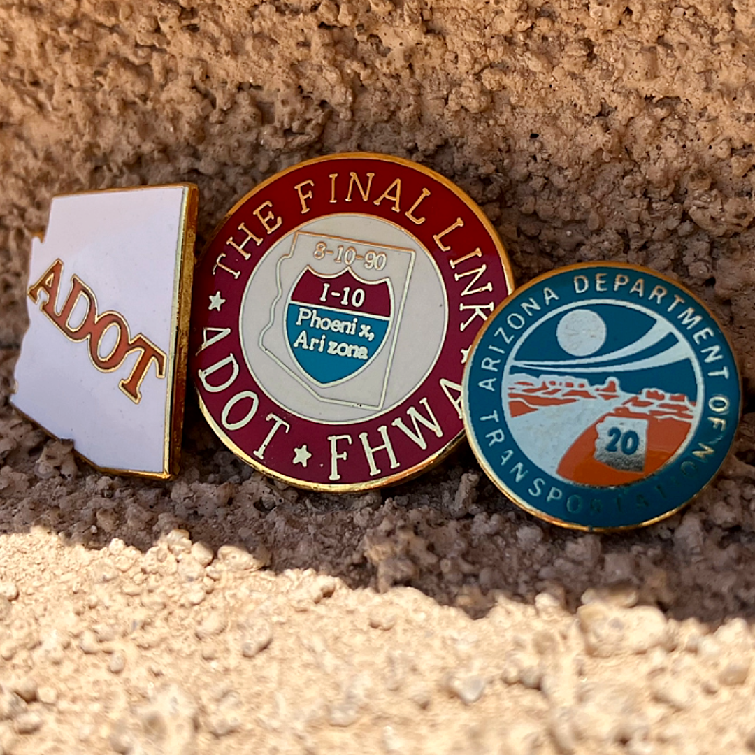
Three pins in the sunshine.

We turn 50 years old this month and have many milestones to celebrate! With a myriad of walks down memory lane this month, we’ve got one here that may be a bit more personal. At least for one ADOT employee.

About a month ago, we got a tip from an inside source that a local thrift shop received several pins once owned by an ADOT employee. And if a picture is worth a thousand words, these three commemorative items can tell a whole story.

We start with this pin, in the shape of the State of Arizona, etched with “ADOT” in the agency’s original orange color. Unfortunately, we’re unable to place the year or timeframe of when this pin was made.

This pin, however, shows an exact and very special date in the agency’s, and nation’s for that matter, history. This one commemorates “The Final Link” of Interstate 10 with the opening of the Deck Park Tunnel on August 10th, 1990. The tunnel truly marked the final link, as Interstate 10 was finally finished from Los Angeles, California to Jacksonville, Florida.

Next up is a pin bestowed to ADOT employees with 20 years of service. You see the 20 inside a shape of Arizona surrounded by a desert landscape in the agency’s primary colors at the time. We thank the pin-owner for serving the people of Arizona for at least two decades. 

Have you ever found something significant to your life or place of business in a thrift store? Tell us your stories on social media

Governor Hobbs helps ADOT mark its 50th anniversary

Governor Hobbs helps ADOT mark its 50th anniversary

I-17 101 traffic interchange

Governor Hobbs helps ADOT mark its 50th anniversary

Governor Hobbs helps ADOT mark its 50th anniversary

July 8, 2024

Agency is honoring the efforts of staff past and present

PHOENIX – Arizona’s highways have existed almost since statehood in 1912, but the agency overseeing them, the Arizona Department of Transportation, is marking its 50th anniversary this month. 

It’s all because state lawmakers, facing a booming population and accelerating transportation needs, decided to consolidate the Arizona Highway Department and Arizona Aeronautics Department as of July 1974. Since then, ADOT employees throughout the state have expanded the state’s transportation infrastructure, implemented new technologies and innovations, and provided safer and more efficient ways to keep Arizona travelers moving safely.

Governor Katie Hobbs marked this month’s milestone with a letter to ADOT staff highlighting the agency’s accomplishments and innovations, including not just highways but the AZ511 traveler information system and AZMVDNow.com, the online portal through which Motor Vehicle Division customers can conduct dozens of transactions. 

“Most importantly, it is ADOT’s dedicated employees, past, present, and future, who shape our state’s transportation system through public service and leadership that ensures AZ families make it to their destinations safely,” Governor Hobbs said. 

When ADOT was created, there were about 5,800 miles of state highway and the interstate system in Arizona was 86% complete. Since then, ADOT has added more than 1,100 miles to the state’s transportation system. 

“Our state is more connected than ever,” ADOT Director Jennifer Toth said. “ADOT employees have worked hard over the decades to expand and improve Arizona’s transportation system. Because of that, people can safely travel throughout our state and businesses can grow.” 

ADOT has had seven other directors over five decades, including Mary Peters, who served from 1998 until 2001, when she became administrator of the Federal Highway Administration (FHWA). In 2006, Peters became U.S. Secretary of Transportation. Former ADOT Director Victor Mendez also served in Washington, D.C., as FHWA administrator for five years, and then was U.S. Deputy Secretary of Transportation from 2014 to 2017.  

The award-winning Arizona Highways magazine, which was founded in 1921, continued to be produced by ADOT. By inheriting Grand Canyon National Park Airport, which began operations in 1967, ADOT became the first state DOT with its own airport.

Arizona’s transportation system has seen a great many changes over the last five decades. Interstate 17 was completed to Flagstaff in 1978. In 1990, the Papago Freeway’s dedication in Phoenix marked the completion of I-10 through Arizona, and a year later ADOT completed the US 60 Superstition Freeway. Recent accomplishments include completing the Loop 202 South Mountain Freeway in 2019 and dedicating flyover ramps in Nogales connecting the important commercial route SR 189 with Interstate 19. 

In terms of technology, ADOT was the nation’s first to develop a thermal camera-based detection and warning system to reduce the risk from wrong-way drivers and to deploy a pilot dust detection and warning system on 10 miles of I-10 between Tucson and Phoenix. 

ADOT is fortunate to have a handful of employees who have been along for all 50 years.

“I get to work with and learn from some of the best and brightest people,” said Ed Green, a 62-year state employee who started with the Arizona Highway Department and now is a hazardous material coordinator in ADOT’s Environmental Planning Group. 

“Not only ADOT, but the world has changed with the inclusion of available technologies that make our tasks easier and quicker,” said Tami Wollaston, who started as a draftsman nearly 51 years ago and currently is a transportation engineering specialist in ADOT’s Roadway Engineering Group. 

“Over time this agency also has included necessary environmental and cultural features along state highways,” said LeRoy Brady, chief landscape architect in ADOT’s Roadway Engineering Group and a 50-year employee. “We’ve improved highways while maintaining Arizona’s unique beauty.”

In a note to staff, Director Toth pointed to the many ways ADOT has and will continue to safely connect people and empower Arizona’s economy by providing not just highway infrastructure but transportation services. 

“Beyond highways, ADOT has evolved in many other areas as well – all thanks to the dedicated people who have worked to continuously innovate and improve the way we operate,” Director Toth said.


ADOT Kids: Building highways is a blast!

ADOT Kids: Building highways is a blast!

SR24-1

ADOT Kids: Building highways is a blast!

ADOT Kids: Building highways is a blast!

By Mary Currie / ADOT Communications
July 4, 2024
Four before-and-after photographs that show how much earth blasting removed.

Have you ever wondered what it takes to move mountains?

Let’s dig in and learn more! 

The I-17 Improvement Project corridor is one example of an ADOT project that required entire sections of the mountainsides to be blasted and excavated to make way for additional lanes. That includes 15 miles of widening and 8 miles of flex lanes along the entire 23 miles from Anthem Way to Sunset Point. 

The rock and material removed during the blasting process were hauled to another area of the project to be used again in the new roadway. A large portion of the blasted material was crushed and then used as aggregate base, embankment and rock mulch along the 23 miles of new lanes. The construction team recycled the rock to eliminate the need to purchase new material and cut down on construction costs. 

In the areas where rock material was too hard to be ripped it needed to be blasted instead to widen the roadway. Crews had just one hour to close the highway to nighttime travelers. Many times the highway was only closed for 20 minutes to complete the blasting  operation, clear the debris and reopen the highway as shown in this video

Each blast was made up of individual explosions that are timed to detonate only milliseconds apart. That is about the speed of a human eye blink. Watch this second video and notice the sequence of light flashes as an explosion occurs. Timing each blast to happen one after the other rather than all at the same time, helps to make the blast safe and control the rock fragments to fall in one location. That helps excavators, loaders, bulldozers and dump trucks haul away the rock quickly and more efficiently. The infographic shows how much rock was moved during the project.

Behind the scenes, work is directed by a blasting engineer who must first create a plan. The plan is important because it shows the location of the rock planned to be blasted and where holes will be drilled in the rock to hold a specific amount of the blasting material. 

These are the some of the important steps required to manage the blasting operation:  

  • Make sure all personnel and traffic is at least 2,500 feet away from the blast.
  • Start the countdown for everyone to hear and then execute the blast.
  • Inspect the results of the blast and confirm all of the explosives have detonated.
  • Provide the "all clear" so that crews may begin moving the rock and debris.
  • Confirm the highway may be reopened to traffic once the roadway is clear of debris.An infographic that shows how much rock was removed during blasting.


ADOT’s Senior Resident Engineer Joshua Wentzlof PE, is one of three resident engineers working on the I-17 Improvement Project, and he is familiar with this type of blasting operation. The PE or Professional Engineer designation after Wentzlof’s name references an engineer who is licensed to practice in the profession of engineering.

“The favorite part of my job is the constant problem solving and seeing a project being built from start to finish,” said Wentzlof. “I would say math and science skills are essential for construction engineering. These subjects require you to practice and use your problem-solving skills, which are put to use on a daily basis in construction. Geometry, especially in road construction, is important when reading construction plans.”

Wentzlof began his career with ADOT after receiving his civil engineering degree from Northern Arizona University.  He joined the department’s Engineer In Training (EIT) program and spent five years gaining experience in construction planning and managing large projects before becoming a resident engineer. 

The I-17 Improvement Project is just one of many roadway construction projects happening on state highways in Arizona. If a career in roadway engineering sounds like a blast to you, read about what some ADOT engineers say about their EIT training experience. Check out other highway projects ADOT engineers manage every day in Arizona. 

Please visit ADOT Kids for more stories, activities and videos about engineers.


Taking a trip through transportation history

Taking a trip through transportation history

SR24-1

Taking a trip through transportation history

Taking a trip through transportation history

By David Woodfill / ADOT Communications
July 1, 2024
A man stands next to an old safe.

Tucked away in an unassuming government office building in the West Valley is a storage room that's like a portal to a bygone era.

The mundane appearance of the ADOT Motor Vehicle Division building in Phoenix belies the more fascinating history safeguarded inside: a treasure trove of antiques, decommissioned equipment and miscellaneous memorabilia from ADOT’s past.

Unofficially called the “Transportation Museum,” the collection was started more than 30 years ago by longtime ADOT employees Ed Green and Bob Harris.

“Bob Harris and I talked about saving some of the history of the Arizona Highway Department and ADOT probably in the late 1980's,” Green said. “We both had been with the department for several years and thought saving history was important.”

Eventually, Green said that he and Harris, who was ADOT’s Facilities Manager before retiring, had amassed such a large collection, they needed a place to store it. They were eventually able to secure a small area of the Old MVD building on Jackson Street in Phoenix, which was built in 1918.

“That served us well for several years,” Green said. “But the building was due to be assessed for asbestos and the items needed to be removed.”

Eventually, with the help of John Hetzel, ADOT’s current Facilities Manager, they found a new storage location at the MVD building in Maryvale. 

Among the hundreds of interesting items are an old surveyor’s transit, a wooden detonator box, an old executive safe, a collection of old, wooden road signs, a crash helmet used for testing highway speeds, the “Highway Hawk” mascot head, and an old concrete milepost.

“Obviously we would like to see the collection saved and a true museum developed for a secure location to house the project,” Green said. “History is what we are and that is important to record for preparing for the future.”

Find Your Lane: ADOT to Introduce Collector-Distributor Roads in the I-10 Broadway Curve Area

Find Your Lane: ADOT to Introduce Collector-Distributor Roads in the I-10 Broadway Curve Area

SR24-1

Find Your Lane: ADOT to Introduce Collector-Distributor Roads in the I-10 Broadway Curve Area

Find Your Lane: ADOT to Introduce Collector-Distributor Roads in the I-10 Broadway Curve Area

By the I-10 Broadway Curve Improvement Project Team
June 18, 2024
A rendering of an urban freeway.

We’ve made a lot of changes in the I-10 Broadway Curve area during the past few years of construction – but perhaps the biggest changes are coming this summer with the introduction of the new Collector-Distributor (CD) roads along I-10 in both directions between 40th Street and Baseline Road.

And as these CD roads may take some getting used to, we want to provide a brief overview of how they work, so take note!

If you need to get on or off I-10 in either direction in the Broadway Curve area (I-10 between Baseline Road and 40th Street), your route will change.

You may need to exit the freeway earlier or find yourself on a longer ramp to enter or exit I-10 depending on your destination within the Broadway Curve area. These longer exit and entrance ramps are known as Collector-Distributor roads. As their name suggests, the CD roads will collect traffic from the I-10 mainline, State Route 143 and US 60 and distribute it to the CD roads.

For example, westbound I-10 drivers heading to SR 143 will exit I-10 south of Baseline Road to enter the westbound CD road, which eliminates the need for them to merge right in the same area where drivers from US 60 are entering westbound I-10.

Because three freeways converge in this small section of I-10 within the Broadway Curve area, traffic currently backs up when people slow down to transition from one freeway to another.

The idea of the CD roads is to keep the mainline I-10 lanes – or lanes that are for drivers traveling through the area – free from that weaving  by drivers changing lanes to enter or exit the freeway.

For the visual-inclined, we invite you to check out this animation showing how CD roads will work once they open to the public.

The westbound CD road will be almost three miles long, located along westbound I-10 from Baseline Road to 40th Street and is generally three lanes. The eastbound CD road will be just over one and a half miles long, runs along eastbound I-10 from 48th Street to Baseline Road and is generally two lanes.

There will be signage to guide drivers to the correct lanes based on their destinations. Also, there are no traffic signals or stop signs on the CD roads and the speed limit is 55 miles per hour. The roads are not accessible to pedestrians and bicyclists.

Remember it’s important for your safety and the safety of other drivers that you obey the speed limit and avoid distractions while driving on the CD roads.

The westbound CD road is scheduled to begin opening to drivers in early Summer 2024, while the eastbound CD road is scheduled to begin opening in late Summer 2024.

As the CD roads begin to open to motorists, construction on the I-10 Broadway Curve Improvement Project will continue through early 2025, which means there may be times when the CD roads or the I-10 mainline are restricted for construction activities. You can find the latest traffic restrictions on the Project Website or for more information on the I-10 CD roads, visit i10broadwaycurve.com/findyourlane.

It’s a grand reopening for ADOT’s Fredonia commercial port of entry

It’s a grand reopening for ADOT’s Fredonia commercial port of entry

SR24-1

It’s a grand reopening for ADOT’s Fredonia commercial port of entry

It’s a grand reopening for ADOT’s Fredonia commercial port of entry

By Steve Elliott / ADOT Communications
May 12, 2024
Group in front of Fredonia Port of Entry

Visitors to the Town of Fredonia in far northern Arizona may see tongue-in-cheek bumper stickers saying, “Fredonia, AZ: Center of the Universe.” 

It might seem light years away from much of Arizona due to its location at the farthest edge of the Arizona Strip next to Utah, but Fredonia is smack in the middle of wonders such as the Grand Canyon’s North Rim, Zion National Park, Grand Staircase-Escalante National Monument and much more. It’s lovely in its own right as well, set along US 89A and beneath layer cake cliffs so common in the area. 

And as of Wednesday, Fredonia is home once again to a full-time Arizona Department of Transportation commercial port of entry. The photo above is from the port’s grand reopening ceremony held by ADOT’s Enforcement and Compliance Division (ECD), whose mission includes ensuring that commercial vehicles are safe to operate on Arizona highways. 

The Fredonia Port of Entry opened in 1964 due to highway use by trucks serving the agricultural, logging and mining industries. It was originally staffed by four civilian agents. ADOT closed it in 2008 amid the nation’s economic downturn, though since 2022 ECD officers have been conducting commercial vehicle details there about once a week. 

On Wednesday, with statistics pointing to the need for a regular presence,  ADOT invited the community to celebrate the Fredonia Port of Entry’s reopening. It’s another way ADOT is safely connecting people and empowering Arizona’s economy and the economy in and around the great Town of Fredonia. 

Moving Mountains: Rock blasting now complete for the I-17 Improvement Project

Moving Mountains: Rock blasting now complete for the I-17 Improvement Project

SR24-1

Moving Mountains: Rock blasting now complete for the I-17 Improvement Project

Moving Mountains: Rock blasting now complete for the I-17 Improvement Project

By Laura Douglas / ADOT Communications
May 8, 2024
Rock covers a highway after rock blasting.

If your summer road trip will take you along Interstate 17 north of the Phoenix metro area, you’ll notice that the landscape looks a lot different these days. Entire sections of the mountainsides have been removed through controlled rock blasting, and this major earthwork operation is now complete.

This tremendous effort was necessary to make way for the additional lanes from Anthem Way to Sunset Point. That includes 15 miles of widening and 8 miles of flex lanes along the entire 23-mile I-17 Improvement Project corridor.

Controlled rock blasting began in December 2022 and required full closures of I-17 in both directions to keep everyone safe, including the traveling public. Because I-17 is such a heavily traveled highway, blasting took place at 10 p.m. during the weeknights and involved a very tight schedule. Crews had just one hour to close the highway, carry out the blasting operation, clear the debris, and then reopen the highway.

The team conducted a total of 62 blasts at seven different locations along the project corridor over the course of a year. That’s far less than the initial estimate of 120 blasts. In many circumstances, crews were instead able to “rip” or excavate rock in certain areas using heavy equipment. Ripping is the preferred method of rock removal because it lessens the impacts on traffic. Areas where the rock material was too hard to be ripped needed to be blasted instead.

Approximately 177,000 cubic yards of rock and material was removed during the blasting process, then hauled to another area of the project to be reincorporated into the new roadway. A large portion of the blasted material is crushed and then used as aggregate base, embankment and rock mulch along the 23 miles of new lanes. The construction team is using everything that is removed by putting it back into the project. 

For those of you who want to see what the blasting operations looked like, we’ve got you covered. Check out this highlight reel set to music and this extended version, which includes all of the blasts.

The entire 23-mile stretch between Anthem Way and Sunset Point remains under construction throughout 2024 and into 2025, as the new lanes are constructed and paved and a dozen bridges are either widened or replaced. The 15 miles of new lanes between Anthem Way and Black Canyon City are expected to open by the end of 2024, and the eight miles of flex lanes between Black Canyon City and Sunset Point are expected to open in 2025.

To learn more about the I-17 Improvement Project, visit Improvingi17.com


Can Can Blast with Logo from ADOT Vimeo-External on Vimeo.