Bridges

Pinnacle Peak Road bridge construction gearing up along I-17

Pinnacle Peak Road bridge construction gearing up along I-17

I-17 101 traffic interchange

Pinnacle Peak Road bridge construction gearing up along I-17

Pinnacle Peak Road bridge construction gearing up along I-17

April 16, 2019

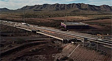
PHOENIX – A new bridge to carry Pinnacle Peak Road traffic over Interstate 17 will start to take shape over the next month as part of improvements coming to north Phoenix.

The Arizona Department of Transportation’s $50 million project is designed to improve traffic flow and safety by rebuilding the I-17 older interchanges at both Pinnacle Peak and Happy Valley roads.

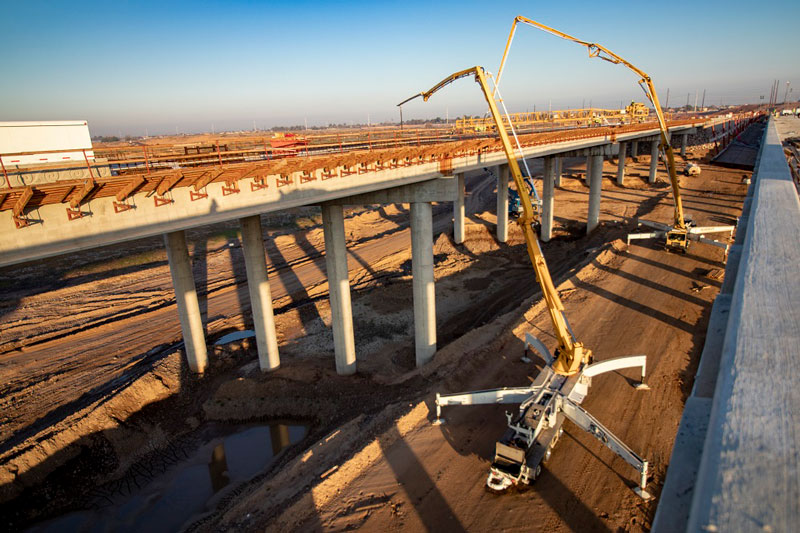
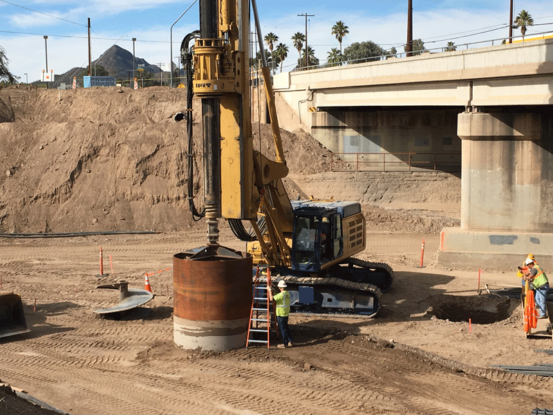
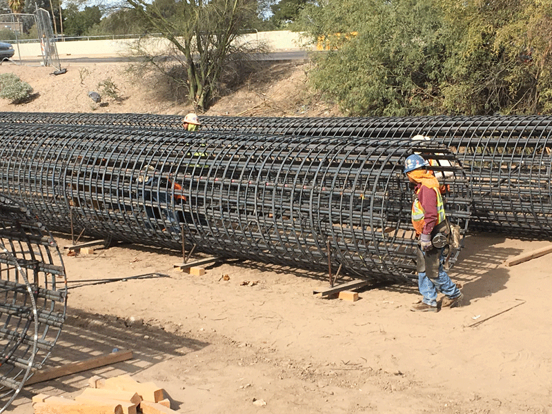
In addition to building bridge abutment walls, crews this month will pour concrete for two 19-foot-tall pier columns along the center median of I-17 at Pinnacle Peak Road. The columns will help support the steel-reinforced concrete girders that will hold the Pinnacle Peak bridge deck. Crews are scheduled to place girders in mid-May.

Overnight lane restrictions are scheduled along Pinnacle Peak Road near I-17 the next two weeks for the bridge work. Eastbound Pinnacle Peak Road will be narrowed to one lane at the I-17 interchange from 10 p.m. to 5 a.m. Wednesday and Thursday nights (April 17-18) this week. The same restriction is scheduled Monday through Thursday nights next week (April 22-25).

Drivers also can expect construction work to ramp up near I-17 and Happy Valley Road, where crews are building a diverging diamond interchange to replace the existing two-lane bridge and roundabouts.

The bridge work, including girder placement, will require more than a dozen full closures of I-17 in the project area between May and November, with many of them scheduled during overnight hours and on weekends. Specific information about restrictions and detour routes will be provided in advance of any closures.

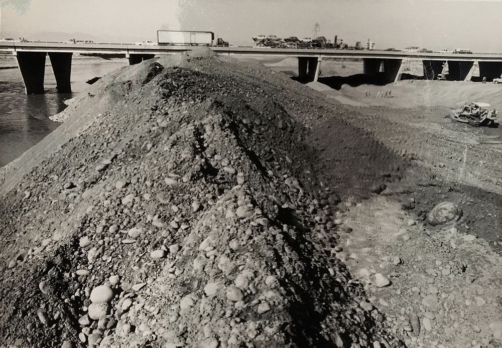
Since the project started in November 2018, crews have focused on utility relocations, soil stabilization and building up embankments at both of the adjacent interchanges. An upgraded drainage culvert beneath Pinnacle Peak Road east of I-17 also has been completed.

The I-17/Happy Valley and Pinnacle Peak interchanges project is scheduled for completion in fall 2020. More information is available at azdot.gov/I17TrafficInterchanges.

On the road: A visit to Canyon Diablo Bridge

On the road: A visit to Canyon Diablo Bridge

On the road: A visit to Canyon Diablo Bridge

On the road: A visit to Canyon Diablo Bridge

March 29, 2019

By Kathy Cline / ADOT Communications

This bridge may look like a ruin in the middle of nowhere, but it's one of Arizona's earliest examples of vehicular bridge construction.

Canyon Diablo Bridge used to carry Route 66 over Canyon Diablo, about 30 miles east of Flagstaff (the ghost town of Two Guns is near its east end). According to the National Park Service, Arizona State engineer Lamar Cobb selected and surveyed the location; plans and specifications were purchased for $500 from the Topeka Bridge & Iron Co. Thomas Maddock of Williams, Arizona, built the bridge for $9,000.

Canyon Diablo Bridge opened to traffic in 1915. Designed to deal with occasionally violent floods through Diablo Canyon, its upstream wall was solid to protect the roadway, while the downstream wall had slots to allow water through.

At first, the bridge was part of the Santa Fe Highway (national name: Old Trails Road), which became part of U.S. Route 66 in 1926. This bridge fell out of use in the 1930s, when a new bridge was put up just to the north of this one. That bridge followed Interstate 40 at Two Guns.

The Canyon Diablo Bridge was added to the National Register of Historic Places in 1988.

Visiting this bridge is easy: Just take I-40 north to Exit 230 (Two Guns). You'll find the bridge along the historic Route 66, which goes through Two Guns.

Making way for a new SR 89 bridge near Ash Fork

Making way for a new SR 89 bridge near Ash Fork

Making way for a new SR 89 bridge near Ash Fork

Making way for a new SR 89 bridge near Ash Fork

March 20, 2019

By David Rookhuyzen / ADOT Communications

Travelers along State Route 89 south of Ash Fork will see the bridge over Meath Wash come down as crews begin the six-month process of a removing the old structure and replacing it with a cast-in-place, two-span bridge.

The original bridge dates back to 1932 and was widened in 1947.

The replacement bridge will look like the existing one with a few small differences, such as the spans being longer and the shoulders slightly wider. Crews will also reconstruct and re-stripe the approaches to the bridge to improve sight distance because of heavy traffic in the area from a cement plant.

A detour will direct traffic around the closed bridge. Motorists should expect delays in the area while the work progresses.

The bridge itself is expected to be closed for six months, though the overall project, which started at the end of January, is scheduled to last into October.

You can check out more information about the project, and subscribe for emailed updates, at its page on our website.

Bridge improvements will narrow I-15 to one lane in each direction

Bridge improvements will narrow I-15 to one lane in each direction

I-17 101 traffic interchange

Bridge improvements will narrow I-15 to one lane in each direction

Bridge improvements will narrow I-15 to one lane in each direction

March 12, 2019

PHOENIX – Motorists using Interstate 15 in far northwestern Arizona will need to budget extra travel time over the next year as the Arizona Department of Transportation improves the decks of three bridges through the Virgin River Gorge between St. George, Utah, and Mesquite, Nevada.

Starting in April, crews will resurface the decks of Bridge No. 2 and Bridge No. 5, while Bridge No. 4 will get a new deck. Crews will move all traffic to one side of the freeway while working on the other, allowing one travel lane in each direction.

Completing this $6.4 million project, which is scheduled to wrap up in spring 2020, will require reducing the width of travel lanes to 10 feet during construction. All vehicles and loads wider than 10 feet will be required to use a 224-mile detour, with signs directing wide-load traffic to US 93, Nevada State Route 319 and Utah State Route 56 between Las Vegas and Cedar City, Utah.

Along with other improvements ADOT has made to I-15 bridges in recent years, this work will extend the lives of bridges along this busy corridor for commercial and passenger travel.

For more information, please visit azdot.gov/projects and click on the North Central District.

Bridging the past with the future on I-10

Bridging the past with the future on I-10

Bridging the past with the future on I-10

Bridging the past with the future on I-10

March 5, 2019

By Tom Herrmann / ADOT Communications

Driving along Interstate 10 as you passed Eloy in Pinal County, you may not have noticed the bridges that carried traffic over local roads. Six of them, three in each direction, allowed freeway traffic to flow without isolating the communities of Eloy and Picacho.

With new freeway lanes under construction as part of a 4-mile widening project, those six bridges built in the 1960s are no longer needed. The new freeway alignment and a new interchange at State Route 87 that reaches across I-10 will accommodate traffic on I-10 and in those communities.

And so, along with the old freeway lanes, those bridges are coming out. The westbound bridges at SR 87 and LaPalma and Phillips roads have already been taken down. The eastbound bridges will be removed as soon as eastbound traffic is switched to new lanes in January.

You can use the slider above to see the before and after (well, more like during) for one of these demolitions.

The concrete and asphalt from those bridges won't go to waste. We’re using everything freeway – 1 million square feet of asphalt, 30,000 feet of guardrail and 700,000 cubic yards of earth – to build the foundation of the new eastbound lanes. Some of the guardrail will be reused in other projects around Arizona.

US 191 bridge north of Morenci to close for repairs

US 191 bridge north of Morenci to close for repairs

I-17 101 traffic interchange

US 191 bridge north of Morenci to close for repairs

US 191 bridge north of Morenci to close for repairs

February 27, 2019

PHOENIX – A US 191 bridge about 7 miles north of the entrance to the Morenci Mine will close at noon Thursday, Feb. 28, for urgently needed repairs to a bridge abutment.

US 191 will remain open except for the area around the bridge, which is located north of Morenci near milepost 177. There is no estimated time for the bridge to reopen.

Drivers traveling between Morenci and Alpine will need to take US 191 south from Morenci to Three Way, follow SR 78 east into New Mexico to US 180, and follow US 180 north to Alpine.

The bridge was built by Freeport McMoRan, which operates the mine. A recent inspection identified the need to close it for repairs to address deterioration to an abutment that has occurred over time.

VIDEO: Out with the old bridges, in with the new

VIDEO: Out with the old bridges, in with the new

VIDEO: Out with the old bridges, in with the new

VIDEO: Out with the old bridges, in with the new

January 25, 2019

By David Rookhuyzen / ADOT Communications

Today we're using a drone to provide a different perspective on work demolishing the old I-10 bridges over Jimmie Kerr Boulevard in Casa Grande, part of a project widening 4 miles of the interstate to three lanes in each direction.

In between the bridges that are on the way out, you can see new bridges over Jimmie Kerr Boulevard. On Jan. 9, we moved traffic to these bridges.

After the old bridges are removed, crews will add another lane and a full shoulder to each of the new structures.

The project is scheduled for completion in late summer at roughly the same time as another widening project just to the east between Eloy and Picacho.

Throwback Thursday: Over the river

Throwback Thursday: Over the river

Throwback Thursday: Over the river

Throwback Thursday: Over the river

January 24, 2019

By David Rookhuyzen / ADOT Communications

Today we are throwing back to this 1979 photo of construction work under Interstate 10 at the Salt River Bridge.

The photo didn't come with information on what is being done, but it's worth noting that seven floods swept through the Phoenix area between October 1977 and February 1980, including one in January 1979 that washed out many other Salt River crossings.

A flood in 1980, the year after this photo, closed every Salt River crossing except at Mill and Central avenues in Tempe and Phoenix, leading to a Maricopa County project deepening the Salt River channel and projects reinforcing all bridges.

The I-10 bridge pictured here was replaced in the mid-1980s with the bridge you will drive across today on the way to or from downtown Phoenix.

Recently, crews building the future Loop 202 South Mountain Freeway completed the decks of two half-mile bridges spanning the Salt River between Broadway Road and Southern Avenue.

In an area of the southwest Valley with few other all-weather crossings of the Salt River, the South Mountain Freeway will greatly improve mobility when water is flowing. And as this photo shows, that's always a possibility.

Driving surfaces complete on longest South Mountain Freeway bridges

Driving surfaces complete on longest South Mountain Freeway bridges

I-17 101 traffic interchange

Driving surfaces complete on longest South Mountain Freeway bridges

Driving surfaces complete on longest South Mountain Freeway bridges

January 24, 2019

PHOENIX – The largest structures on the Arizona Department of Transportation’s Loop 202 South Mountain Freeway project are nearly complete, with crews finishing the concrete decks of two half-mile-long bridges that will carry traffic over the Salt River in the growing southwest Valley.

Since the first deck pour in November 2017, crews have put down approximately 11,500 cubic yards of concrete to create the driving surfaces for both bridges. That’s enough concrete to build a sidewalk between downtown Phoenix and the town of Queen Creek.

After pouring the concrete, mostly during overnight hours, crews used a self-propelled concrete leveling machine called a Bid-Well to create smooth, uniform decks for the bridges, which are located midway between Broadway Road and Southern Avenue along the 59th Avenue alignment.

Now that the concrete has cured, construction equipment is able to use the bridges for the first time as Connect 202 Partners, the developer of the South Mountain Freeway, moves ever closer to completing work in the 22-mile-long corridor. In addition to aiding construction, using the bridges helps keep trucks off local streets as they carry asphalt and concrete to other areas of the project.

Deck construction is one of the final steps in building a bridge. Construction of the Salt River bridges began in early 2017 with substructure work creating piers and abutments to support the bridge. Crews installed 292 girders that are the largest of their kind ever used for an ADOT project.

The Salt River bridges will provide a much-needed crossing to and from Laveen, especially when the river flows, while also reducing congestion at current crossings. The city of Phoenix’s 51st Avenue bridge is currently the lone all-weather Salt River crossing between 35th Avenue and Avondale Boulevard.

Final bridge construction will include completing lighting and painting, and installing barrier walls.

Scheduled to open as early as late 2019, the South Mountain Freeway will provide a long-planned direct link between the East Valley and West Valley and alternative to Interstate 10 through downtown Phoenix. Approved by Maricopa County voters in 1985 and again in 2004 as part of a comprehensive regional transportation plan, the South Mountain Freeway will complete the Loop 202 and Loop 101 freeway system in the Valley.

For information on the project, visit SouthMountainFreeway.com.

Bridge piers are like icebergs: There's more than you think below the surface

Bridge piers are like icebergs: There's more than you think below the surface

Bridge piers are like icebergs: There's more than you think below the surface

Bridge piers are like icebergs: There's more than you think below the surface

January 16, 2019

By Tom Herrmann / ADOT Communications

Every time you drive by an overpass, you see the cement-and-steel columns that support the roadway. There could be only a few on a small overpass, or more than a dozen in larger overpasses like the ones at two current projects on Interstate 10 in Pinal County. They usually hold the overpass 15-20 feet above what's below.

What you don’t see is just how low they go.

A typical bridge column drops down about 80 feet underground – about the height of an eight-story building.

Each pier includes a cylinder of rebar steel about 6-8 feet in diameter, woven into a lattice that creates hundreds of squares no more than 1 foot across. Each of those squares is tied together – by hand – to strengthen the concrete that is poured on top to create what's known as a caisson (this 2011 video shows the process).

Blog-2019-0116-ajo-rebar

Why so deep? Friction.

The bridge columns are in place not only to hold the overpass up but to keep it steady. It’s essential that each overpass be held firmly in place. The deep columns create friction with the surrounding ground, preventing the bridge from moving despite thousands of vehicles crossing a typical overpass every day, and weather bringing rain and crosswinds. Combine 10 or more columns and the friction is enough to hold a bridge steady for decades.

Overpasses like the ones being built today in places like Maricopa and Tucson are built to last 50 years or more. One way to make sure they serve that long is to give them a good foundation. By digging so deep, ADOT is doing just that.