Construction

Flashback Friday: Mule crews

Flashback Friday: Mule crews

Flashback Friday: Mule crews

Flashback Friday: Mule crews

By David Rookhuyzen / ADOT Communications
July 31, 2020

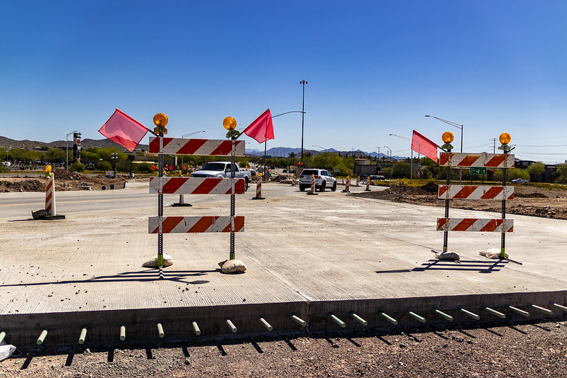
Highway construction is and has been labor-intensive, but after we found this photo we couldn't be happier to be living in our modern, mechanized age.

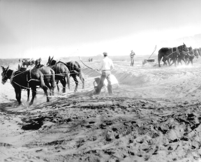
Because these folks here driving the livestock are not farmers out plowing a field. They are actually Arizona Highway Department crews in the process of grading a highway. US 60 between Salome and Aguila, to be exact. This mule-driven photo is from Dec. 7, 1933.

As you might know, grading is the process of smoothing the base layer of a road to remove divots, washboards and other high or low points. For dirt roads, such as this stretch of US 60 (which would also be co-signed with US 70 for a time), grading is basically all the roadwork and maintenance that is done. Today construction crews have grading machines for this type of work. We can only imagine those machines are a bit more reliable than the mules and produce less ... um ... waste.

The year this photo was snapped is significant because it was actually a bit of turning point for highway construction in Arizona. According to our report on the state's transporation history, that year the federal Public Works Administration gave Arizona $5.2 million for road projects, which covered hundreds of miles of grading and draining, oiling, sealing and paving, along with bridge construction, shoulder-widening and railroad-crossing construction.

By 1933, Arizona was also the leading state in the West when it came to oiling, or spraying "low-type bituminous surfacing" on, gravel roads. At the start of the year, more than 1,000 miles of state highways had been oiled, and when State Route 87 in Chandler was surfaced, for the first time a person could drive between Phoenix and Tucson without driving on a single stretch of a gravel road. At the end of 1933, the state reported that all its highways, with limited exceptions, had been oiled or actually paved.

That's all fascianting for us, but it most likely meant little to our mule-driving friends here, who were probably just happy if their stubborn charges kept the grader moving.


Portable signs point the way to bypassing I-17 work zone

Portable signs point the way to bypassing I-17 work zone

Portable signs point the way to bypassing I-17 work zone

Portable signs point the way to bypassing I-17 work zone

By Doug Nintzel / ADOT Public Information Office
June 23, 2020

The important ongoing project to reconstruct the Interstate 17 bridge over Central Avenue south of downtown Phoenix remains in an early stage. But before the work got started, our staff at ADOT knew the bridge work zone would present challenges for drivers who use the stretch of I-17 between the I-10 “Stack” and “Split” interchanges.

A decision was made to incorporate a “Smart Work Zone” safety innovation into the I-17 project at Central Avenue. As you can see in this ADOT video, the project team has followed through with the placement of portable message signs on trailers at nearby freeway locations to provide drivers with travel times for both I-10 and I-17 in the downtown area.

For example, one of our message signs along westbound I-10 near Phoenix Sky Harbor International Airport provides both I-10 and I-17 travel times. That allows drivers to compare the estimated travel time for using northbound I-17, which includes the work zone, or what to expect by staying on I-10 in the downtown area.

On average, the optional I-10 route that includes traveling through the Deck Park Tunnel is saving drivers five or more minutes of commute time, not to mention avoiding the frustration associated with slow moving traffic in a work zone. Even with lighter traffic conditions on freeways during the current health situation, there are times when slow downs and backups occur on I-17 in the area approaching the bridge work at Central Avenue.

The portable sign system uses traffic data to calculate the estimated travel times to predetermined destinations. This system is much like the one used to provide drivers with valuable travel times on ADOT’s permanent electronic message boards along Valley freeways.

As part of this pilot project, portable message boards also have been placed in areas along I-10 approaching interchanges connecting to the new Loop 202 South Mountain Freeway. Those signs also provide drivers with estimated travel times for using either Loop 202 or I-10 through the downtown Phoenix region.

ADOT has recently established several Smart Work Zone initiatives to help offset challenges associated with keeping traffic moving while construction is taking place. Those innovations include an I-15 queue warning system in the Virgin River Gorge, providing drivers with information to prepare for stop-and-go conditions ahead. Another example is the I-40 dynamic merge system east of Flagstaff that adjusts methods for merging depending on conditions near a bridge project at Meteor Crater.

ADOT Kids: Two fun construction activities!

ADOT Kids: Two fun construction activities!

ADOT Kids: Two fun construction activities!

ADOT Kids: Two fun construction activities!

May 12, 2020

EDITOR'S NOTE: During this unprecedented time, ADOT is creating transportation activities for kids. Please visit azdot.gov/ADOTKids or use the hashtag #ADOTKids on ADOT's Twitter, Facebook and Instagram accounts to see what we have going on.

By Steve Elliott / ADOT Communications

I hope you've enjoyed our latest ADOT Kids activity focusing on the Loop 202 South Mountain Freeway and how we use designs and landscaping to make freeways nice places to be. Please remember to send us your freeway design art by 5 p.m. Wednesday, May 13, so we can include it in our slideshow of everyone's work.

If you've finished your design and are looking to do something else fun, some creative people I work with have come up with a word search and a construction zone maze. Depending on your age and interests, you can print one or both by clicking the images below.

You'll find these and other activities at the ADOT Kids home page, azdot.gov/ADOTKids

Have fun, everyone!

South Mountain Freeway word search:


Work zone maze:


ADOT Answers: Why don't I see construction?

ADOT Answers: Why don't I see construction?

ADOT Answers: Why don't I see construction?

ADOT Answers: Why don't I see construction?

By David Rookhuyzen / ADOT Communications
May 12, 2020

Driving through construction zones may not be the most enjoyable experience, but at least there's the promise of an improvement to come.

So we understand if it's might be a little confusing if you don't see anyone while driving through a work zone. We're often asked on ADOT's social media accounts why drivers don't see work happening when lanes are closed in a particular work zone.

About 90 percent of the time, when drivers don't see work happening, it's because crews are doing the lion's share of the construction when traffic is lighter, according to Jesse Gutierrez, ADOT's deputy state engineer for operations. Many times the work itself is being done at night, when additional lanes may close and crews and equipment will be in the construction zone. 

"Typically we are coming back within hours to do work," Gutierrez said.

As we told you about in a blog last year, ADOT schedules what work it can at night. However, there are several factors, such as noise or the type of work being done, that won't let construction occur at night. When work is scheduled for daylight hours, contractors will often work in shifts that avoid high-traffic times of days simply because it's safer when less people are on the road.

Gutierrez said that another reason is that construction work might have only a certain window of time when it can be done. In cases where work will temporarily impact a utility, such a power line, water main or even a canal, construction has to be scheduled when it will affect the fewest people.

There few other reasons, like construction halting several days before and after a major holiday, but they are less common, Gutierrez said.

But if construction is happening at other times, then why are there still cones and barricades up when you are driving home? The answer comes down to safety. ADOT follows certain standards to protect the driving public while construction is happening. Part of that is physically separating traffic from any potentional hazards in the work zone. And if a lane needs to be closed, a long taper is needed to help traffic move over long before it reaches where the work is happening. 

The goal is always to compete projects as quickly and safely as possible, even if there is no one around to see it.

Work Zone Awareness Week has extra significance this year

Work Zone Awareness Week has extra significance this year

I-17 101 traffic interchange

Work Zone Awareness Week has extra significance this year

Work Zone Awareness Week has extra significance this year

April 17, 2020

PHOENIX – For ADOT, National Work Zone Awareness Week is always a big deal. It means more this year.

Last month, one of our own, Frank Dorizio, was struck and killed in a work zone on Interstate 10 south of Phoenix. A member of ADOT’s Incident Response Unit, Dorizio was setting up traffic control for a pavement project.

“Every day in Arizona, hundreds of men and women step into work zones on our highways, their place of work for the day, to build, maintain and improve our roadways,” ADOT Director John Halikowski said. “Like everyone, they deserve a safe work environment, and National Work Zone Awareness Week gives us the opportunity to remind drivers that they must make safe decisions when approaching and driving in a work zone. Because if they don’t, people can die.” 

While ADOT mourns Dorizio, the first ADOT worker since 1998 to be struck and killed while working along a highway, too many crashes are occurring in work zones across Arizona. From 2017 to 2019, 3,540 collisions in work zones resulted in 49 fatalities on Arizona roadways. 

These are preventable crashes, and, in most incidents, those killed are vehicle occupants. According to national statistics, annually, more than 80% of those killed in crashes that occurred in work zones were vehicle drivers or passengers.

Making smarter decisions when approaching and driving in work zones will not only keep road workers and vehicle occupants safer, it will keep roads open and in peak condition. That’s incredibly important in the current public health situation. ADOT crews continue working to keep roadways open for all who use the state highway system, including commercial trucks carrying needed supplies to our homes, stores and hospitals. 

“The people of Arizona rely on ADOT to keep their highways safe and open,” said Dallas Hammit, ADOT’s state engineer and deputy director for transportation. “Our crews continue to work on roadways, building, improving and responding to incidents. To drivers, we say, ‘Help us help you.’ Make safe decisions when driving so all of us can return home at the end of the day.”

Drivers can make work zones safer by following these tips:

  • Pay attention: Observe and obey posted warning signs, as well as flaggers. You can be cited for disobeying a flagger’s directions.
  • Drive alert: Speed limits might be lowered, travel lanes could be narrowed or eliminated, and people may be working near your travel lane.
  • Slow down: Speeding is one of the leading causes of work zone crashes.
  • Merge safely: Do it carefully and as directed by signage.
  • Don’t tailgate: The most common crash in a work zone is the rear-end collision. Don’t follow too closely.

For more information about work zone safety, please visit FocusOnDriving.com.

ADOT accelerating I-17 bridge improvement project in Flagstaff

ADOT accelerating I-17 bridge improvement project in Flagstaff

I-17 101 traffic interchange

ADOT accelerating I-17 bridge improvement project in Flagstaff

ADOT accelerating I-17 bridge improvement project in Flagstaff

April 8, 2020

PHOENIX – The Arizona Department of Transportation is accelerating a project to widen and improve the Interstate 17 bridge over McConnell Drive entering Flagstaff by closing McConnell Drive until early May, followed by other restrictions through mid-August.

McConnell Drive is scheduled to be closed around the clock from Monday, April 13, through Friday, May 1. Beginning Saturday, May 2, McConnell Drive is scheduled to be closed between 5 a.m. and 7 p.m. daily through Sunday, May 31, while crews work on the next phase of the project. 

From June 1 to Aug. 17, McConnell is scheduled to be closed 24/7. The I-17 off-ramp to McConnell Drive also will be closed during this time.

For access to Northern Arizona University, drivers can use Milton Road and take University Drive to Knoles Drive. For access to west Flagstaff, drivers can use Milton Road and take Forest Meadows Street to Beulah Boulevard.

Due to reduced traffic volumes with NAU shifting to online instruction, ADOT and its contractor, FNF Construction, decided to start full closures of McConnell Drive this month instead of waiting for summer. This will allow the project to finish ahead of schedule and potentially eliminate the need for intermittent closures that were originally planned during the fall semester.

Working with reduced traffic volumes will also improve safety for the construction workers, as will working during the day, when workers are more visible. 

The project, which is coming out of winter hiatus, involves a full bridge deck replacement, bridge widening and sidewalk construction on the north side of McConnell Drive. The sidewalk construction and initial widening work was completed last year.

For more information, visit azdot.gov/projects and click on the North Central District.

2020 Census: You count when it comes to transportation

2020 Census: You count when it comes to transportation

I-17 101 traffic interchange

2020 Census: You count when it comes to transportation

2020 Census: You count when it comes to transportation

April 1, 2020

PHOENIX – Why is it important for you to get around to responding to the 2020 Census? One of the many reasons is especially important here at the Arizona Department of Transportation: Census results affect how we and others help you get around.

From the highways and local streets you drive to the bridges you cross to the public transportation you use, results of the 2020 Census will influence the allocation of limited transportation funding. 

“The various programs and allocation formulas are complex, but the theme is simple: You count when it comes to the 2020 Census and its importance to Arizona’s state and local transportation systems,” ADOT Director John Halikowski said. “That’s one more reason why participating helps ensure a brighter future for you and every other Arizonan.”

Full participation is especially important when it comes to getting Arizona’s rightful share of all types of federal funding. According to census.gov, each year more than $20.5 billion in federal funding to Arizona for transportation, community centers, housing, medical services and more can be tied to the census count. That’s nearly $3,000 per person per year. 

“An undercount could result in a direct loss of millions of dollars over the next decade,” said Debbie Johnson, director of the Arizona Office of Tourism and chair of the Arizona Complete Count Committee. “By responding to the Census, we can preserve the outstanding quality of life Arizona offers and plan for our future.”


I-10 widening in Eloy

Federal funding plays a big role in transportation. The federal share for most highway, road and street projects in Arizona is more than 90%, and federal funding also contributes significantly to public transit. 

In fiscal 2019, the U.S. Department of Transportation authorized nearly $737 million in federal funding for Arizona. Much of that annual allocation goes toward programs improving the national highway system, addressing congestion mitigation and air quality, and supporting metropolitan planning and surface transportation. Each of these relies to a varying degree on census data, including but not limited to population.

Also consider your local streets. Even though they aren’t part of the state highway system, full participation in the 2020 Census helps ensure that your community gets its proper share of transportation funding, not just from the federal government but through the state’s Highway User Revenue Fund (HURF).

Many of the federal transportation programs relying on census data also apply to local governments and metropolitan planning organizations. There was nearly $100 million in such funding in fiscal 2019.

Do you take the bus, light rail or trolley?  Check, check, check when it comes to the importance of population in allocating federal dollars. Population is a leading factor in how the Federal Transit Administration allocates funds for the formula grants ADOT administers for rural areas, going toward capital, planning and operating assistance. It’s also a leading way the federal government allocates formula grants for transit capital, operating assistance and planning in urban areas. 

By today, April 1, every home in Arizona will have received an invitation to participate in the 2020 Census. You can respond online, by phone and by mail.

For more information and for a link to fill out the Census online, please visit census.gov. You also can help by following and sharing from @AZCensus2020 on Twitter, Facebook and Instagram.

A big day not just for Nogales but for all of Arizona

A big day not just for Nogales but for all of Arizona

A big day not just for Nogales but for all of Arizona

A big day not just for Nogales but for all of Arizona

By Steve Elliott / ADOT Communications
March 13, 2020

On March 4, Governor Doug Ducey and others gathered in Nogales to break ground for a project improving State Route 189, the 3.75-mile state highway connecting the Mariposa Port of Entry and Interstate 19. This is a big deal not just for Nogales and Santa Cruz County but for all of Arizona and beyond, as SR 189 carries a large share of the winter produce consumed in the United States and plays a big role in the state economy. 

The Mariposa Port of Entry saw about $24.1 billion in imports and exports in 2018, and up to 1,800 commercial trucks a day use SR 189 during winter months.

The video at right allows you to experience the excitement of the groundbreaking ceremony and learn more about the $134 million in improvements coming to SR 189, known locally as Mariposa Road. These include flyover ramps connecting with the interstate that will eliminate the need for commercial trucks to stop as many as three times between I-19 and the international border.

With the flyover ramps connecting with SR 189 west of Frank Reed Road, the improvements will enhance safety for students of nearby Nogales High School. The project also includes a new roundabout at Target Range Road and improved drainage and traffic signals. 

Construction is expected to begin in April and take about 18 months to complete. You can learn more about SR 189 improvements and their value to Arizona's economy at azdot.gov/SR189

Busy freeway construction season underway in Phoenix area

Busy freeway construction season underway in Phoenix area

I-17 101 traffic interchange

Busy freeway construction season underway in Phoenix area

Busy freeway construction season underway in Phoenix area

February 25, 2020

PHOENIX – It is going to be an especially busy next several months for Phoenix-area freeway improvement projects. And yes, that means closures are needed to accomplish the work.

Drivers should plan for weekend and overnight restrictions as the Arizona Department of Transportation’s current slate of construction and maintenance projects advances in a number of Valley areas.

“Warmer weather is a big reason for work gearing up now,” said Steve Boschen, who leads ADOT’s Infrastructure Delivery and Operations Division. “That’s especially true of paving work. But we also have projects at stages that involve major work and traffic restrictions.”

Freeway work in the coming weeks and months will include ongoing construction of new lanes along two sections of Loop 101, bridge work along Interstate 17 in north Phoenix and pavement maintenance in a number of areas, including work now underway along Loop 202 (Santan Freeway) in the Chandler area.

Drivers can ease some of the challenges associated with closures by staying informed, planning alternate routes and allowing extra travel time.

ADOT provides real-time information on projects, restrictions and traffic conditions via its Twitter (@ArizonaDOT) and Facebook (facebook.com/AZDOT) accounts as well as the 511 phone line and 511 app available for iOS and Android. The Arizona Traveler Information website at az511.gov allows you to receive information on travel routes you designate.

ADOT also makes good use of freeway message signs to advise motorists of upcoming planned restrictions.

ADOT’s top advice for Valley drivers? Sign up to receive the agency’s emailed project updates. It’s as easy as visiting the ADOT website at azdot.gov and clicking on “Subscribe for Updates.” You can choose among various freeways and also receive ADOT’s Weekend Freeway Travel Advisory for the Phoenix area, which is distributed on Thursday afternoons.

Valley freeway construction projects are scheduled within the Maricopa Association of Government’s Regional Transportation Plan approved by county voters in 2004. ADOT manages the construction for the region. Major projects with busy schedules heading into the spring months include:

  • I-17 interchange reconstruction at Happy Valley and Pinnacle Peak roads. Older bridges are being replaced with wider structures as part of a $50 million improvement project scheduled for completion this fall.
  • Separate Loop 101 widening projects along the Price Freeway between Baseline Road and Loop 202 (Santan Freeway) and the Pima Freeway between I-17 and Princess Drive. The $60 million Price Freeway project is scheduled for completion this summer while the $185 million Pima Freeway project across the north Valley is due for completion by spring 2021.
  • I-10 interchange construction at Fairway Drive, east of Dysart Road in Avondale. The $21 million project featuring a new bridge over I-10 as well as freeway on- and off-ramps is scheduled for completion this spring.

Work also is scheduled to continue this year near or along the Loop 202 South Mountain Freeway, which opened to traffic in December. Examples of that work include landscaping and the addition of a top layer of rubberized asphalt along the freeway.

“We do our best to schedule as much work as possible at night in order to limit impacts on traffic,” Boschen said. “We also need weekend closures to accomplish more than you can in one night. That’s a big reason why we’re able to keep projects on schedule – something that many drivers will appreciate.”

Flashback Friday: 'Best announcement' advances Nogales-Tombstone highway

Flashback Friday: 'Best announcement' advances Nogales-Tombstone highway

Flashback Friday: 'Best announcement' advances Nogales-Tombstone highway

Flashback Friday: 'Best announcement' advances Nogales-Tombstone highway

By Steve Elliott / ADOT Communications
February 7, 2020

Ninety-eight years ago, the Tombstone Epitaph's front page shared "about the best announcement that has come to Cochise County on road work for some time."

The State Highway Department's top engineer, Thomas Maddock, informed the newspaper that work had been approved to extend an existing 8.5 miles of highway between Tombstone and Fairbank, a stretch completed in 1919, west to the Santa Cruz County line. That was part of plans to create a highway linking Tombstone and Nogales along the path that today carries State Route 82. The story said Engineer Al Jenkins was moving a construction crew to Cochise County.

"Telephone advices received later from Mr. Jenkins from Patagonia were to the effect that he was breaking camp and loading all equipment today, ready to move tomorrow, and will begin throwing dirt Tuesday," it said. 

That was Tuesday, Feb. 7, 1922, so today is the anniversary of that dirt-throwing.

Various accounts from the time say this highway was an offshoot of the cross-country Bankhead Highway, which followed the path of what was then US 80 (now State Route 80) from the New Mexico line through Douglas, Bisbee, Tombstone and Benson. It then went to Tucson, Phoenix and eventually Yuma. According to the Arizona Republican, one goal of a Tombstone-Nogales highway was linking the Bankhead Highway with Mexico's highway between Mexico City and Nogales. That would create a valuable international connection for what was billed at the time as the USA's only all-weather coast-to-coast route. 

The map at top right, from a mid-1920s Highway Department report, shows the route of the Tombstone-Nogales highway. 

For the work creating 15 miles of highway between Fairbank and the Santa Cruz County line, grading with heavy equipment was to start at both ends, the Tombstone Epitaph said. The article spends quite a bit of time explaining the three camps being established to make this happen, including one at a ranch midway "for equipment, stock and other material." The interactive map at lower right allows desktop and tablet users to learn more about sites important to this construction project.

"The news that work will be started will bring joy to both Santa Cruz and Cochise county road advocates," the article said. 

A 1924 biennial report from the Highway Department's state engineer said crews had completed 52.3 miles, from Tombstone to Patagonia, of what would eventually be a 74.3-mile gravel highway. It noted that the 25 miles in Cochise County had been turned over to the maintenance department by construction crews. 

"This highway throughout is constructed along modern lines and is in excellent condition and repair," the report said. "With possibly the exception of a few miles in Cochise County, which should be sanded where the caliche surface during wet weather is inclined to become somewhat slick, only general maintenance is necessary."

Now State Route 82, the highway passes through gorgeous country, as you can see through these Google Street View images from Fairbank, Sonoita, Patagonia and approaching Nogales. You'll notice that today's highway is no longer gravel, so that somewhat slick caliche surface has long since been taken care of.

Next time I drive it, I'll think about the day almost a century ago when Al Jenkins' crew began "throwing dirt" to make this beautiful highway a reality.