Numbering Arizona's highways
Numbering Arizona's highways
What’s in a name, or a number for that matter? You’d still be able to “get your kicks” even if it wasn’t called Route 66…
But it turns out there actually is meaning behind our state’s highway names. That’s what we learned after turning to page 39 of “Arizona’s Transportation History,” a publication produced last year by the ADOT Research Center that takes a look back (way back to the 1400s) at the state’s highway system.
Here’s a passage directly from the report that explains how and why Arizona’s highways were numbered.
It was in late 1925 that the final step was taken toward setting up a modern highway network in Arizona. Following guidelines developed by the American Association of State Highway Officials (in 1973 the AASHO changed its name to the American Association of State Highway and Transportation Officials – AASHTO) and approved by the Bureau of Public Roads, the highway department assigned each of Arizona’s highways a unique number, with the east-west roads getting even numbers and the north-south roads getting odd numbers.
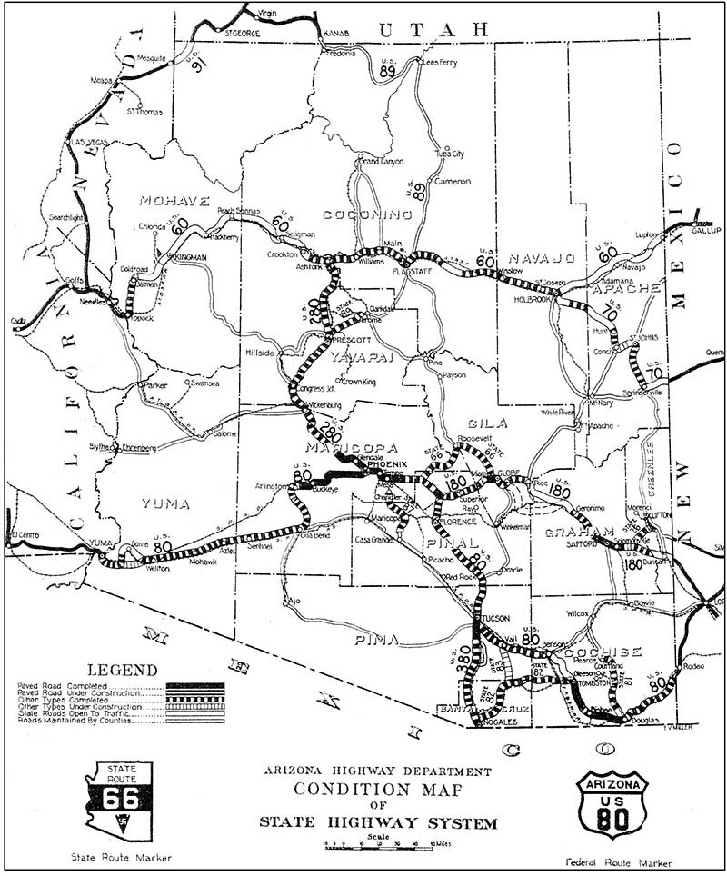
This map of Arizona’s state and U.S. highways can be found in the Arizona Transportation History report. It was published just after the first highway numbers were assigned. Some of the numbers were later changed.
The National Old Trails Highway, which ran from Lupton to Topock via Holbrook, Winslow, Flagstaff, Ash Fork, and Kingman, was initially designated U.S. Route 60. Soon thereafter it was renumbered U.S. Route 66. Under that number, as the celebrated Route 66 connecting Chicago with Los Angeles, this highway would become Arizona’s most famous stretch of roadway. The Springerville-Holbrook alternate route of the National Old Trails Highway was numbered U.S. Route 70, a designation it would lose in the mid-1930s, when it was renumbered U.S. Route 260.
The Lee/Bankhead/Dixie Overland highways, which ran from Rodeo, New Mexico, to Yuma via Bisbee, Benson, Tucson, Florence, Phoenix, and Gila Bend, was numbered U.S. Route 80. This had been Arizona’s first complete east-west highway, and now, as part of U.S. Route 80, it made up one section of the Southwest’s most important highway, connecting El Paso with Tucson, Phoenix, and Los Angeles.
The northern branch of the Lee Highway, from Duncan, on the New Mexico border, to Phoenix via Globe, was designated U.S. Route 180; later, in the mid-1930s, it was renumbered U.S. Route 70.
Parts of the Grand Canyon–Nogales Highway were designated U.S. Route 380 (south of Tucson) and U.S. Route 280 (between Phoenix and Ash Fork), while a new highway from Flagstaff to Fredonia, on the Utah border, was designated U.S. Route 89. Soon the 380 and 280 numbers were dropped, and the entire highway from Nogales to Fredonia was made part of U.S. Route 89, which eventually would connect Mexico and Canada.
Arizona also began numbering its own highways. The first numbered state highways were State Route 79, from Prescott to Jerome; State Route 87, from Mesa to Casa Grande; State Route 88, which was the Apache Trail; State Route 83, from Vail to Sonoita; and State Route 82, from Nogales to Tombstone via Patagonia and Sonoita. Several of these highways still bear the same numbers today.
Another interesting note we found in the report has to do with the now-familiar symbols for U.S. and Arizona highways. According to the report, just as Arizona routes were being given unique numbers, the state also adopted the “shield” symbol for federal highways and the Arizona-shaped signs for state highways.
More from the report on the signs we now know today as the norm…
The Arizona Highway Department also began putting up standardized road signs, under a system devised by the AASHO and approved by the federal government. These included octagons for stop signs, black-on-yellow diamonds for warning signs, and circles for railroad signs. As part of this signing program, all previous signs put up by the private highway associations and local governments were taken down.
For more on Arizona’s transportation history, visit our “From the ADOT Archives” blog posts.