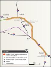
Watch for elk sign
ADOT will use this grant, through the Federal Highway Administration’s Wildlife Crossings Pilot Program, to develop an online mapping tool that will help identify wildlife-vehicle collision hotspots
Engineers Week is a pretty big deal around ADOT, as you might imagine. So we're leading up to the week beginning Feb. 16 by introducing you to ADOT team members who do different kinds of engineering, starting with Jordan Kurlin, a team lead in Roadway Design. 
Map of US 93 Cane Springs project
The Arizona Department of Transportation is starting its latest project to divide US 93 into a four-lane highway between Phoenix and Nevada, this time by widening 4 miles between Wikieup and
911

The Arizona Department of Transportation advises motorists that construction is underway on the US 93 Cane Springs Improvement project located north of Wikieup.

Crews will be working during the next several weeks to clear the work zone in preparation of mobilizing construction equipment to the area. Most of the construction will take place off of US 93 and will have limited impact to motorists. The speed limit will be reduced to allow for heavy equipment to safely access the work zone. 

Located approximately 13 miles north of Wikieup, the project will include the following elements:

  • Widening a 4-mile segment of US 93 from a two-lane undivided roadway to a 4-lane divided highway between mileposts 106 and 110.
  • Constructing two new bridges over Cane Springs Wash and removing the existing bridge (milepost 109).
  • Improving and/or installing drainage and sediment-control facilities, including culverts, pipes and ditches. 
  • Reconstructing the intersection turnout at Upper Trout Creek Road.

The project is expected to be completed in 2027.

Close alert
Aerial shot of I-10 and Broadway Road bridges under construction
The Arizona Department of Transportation advises motorists to plan ahead and expect to use detours as eastbound Interstate-10 will be closed between State Route 51 and US 60 from 10 p.m. Friday, Jan
riggs-road-traffic-interchange-at-sr-347-study-map

Overview

This project, now in the final design stage, will reconstruct the existing intersection to separate SR 347 from Riggs Road traffic on a new bridge.

The purpose of the project is to provide free-flowing traffic movements along SR 347 as it passes Riggs Road to reduce traffic

SR 347/Riggs Rd Final DCR Appendix K

SR 347/Riggs Rd Final DCR Appendix J

SR 347/Riggs Rd Final DCR Appendix I