Interstate 10 and State Route 210 Study
Interstate 10 and State Route 210 Study
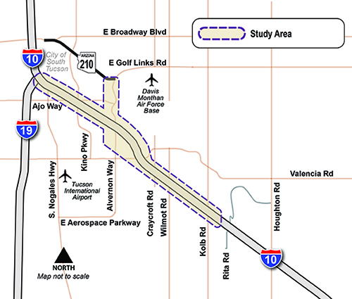
The Arizona Department of Transportation (ADOT) has prepared a Environmental Assessment (EA) and Design Concept Report (DCR) to study potential improvements to two important corridors that serve the Tucson area:
- Interstate 10 (I-10) from the I-10/Interstate 19 (I-19) interchange to Kolb Road
- State Route 210 (SR 210) (Barraza‑Aviation Parkway) from Golf Links Road to a future connection with I-10 along Alvernon Way
Background
Beginning in 2011, Phase 1 of the long-range planning process for these corridors included a Feasibility Study and Environmental Overview. The Feasibility Study, which was completed in 2015, examined future transportation needs and potential improvements, and the Environmental Overview identified potential environmental issues in the study area. The Feasibility Study compared the benefits and disadvantages of five potential alternatives, and based on those findings, two build alternatives and one "no-build" (nothing changes) alternative were moved forward to be studied in Phase 2.
As part of Phase 2 of the study, an Environmental Assessment (EA) and a Design Concept Report (DCR) were prepared. They recommend the following improvements:
- Designating Alvernon Way as SR 210 from Golf Links Road to I-10 and adding one (1) lane in each direction
- Adding a new system interchange to provide access from SR 210 to I-10
- Adding up to two (2) lanes in each direction on I-10 from the I-10/I-19 interchange to Alvernon Way
- Adding up to four (4) lanes in each direction on I-10 from Alvernon Way to Kolb Road
Need more information?
- Phone: Call the ADOT Project Information Line at 855.712.8530
- Online: Submit a question or comment online (select Projects from the drop-down menu)
- Mail: ADOT Communications
1655 W. Jackson Street MD 126F
Phoenix, AZ 85007
Timeline
Phase 2 Study Timeline
- Dec. 2020 - Final Design Concept Report released
- Aug. 2020 - FONSI approved and Final Environmental Assessment released to the public
- Nov. 2019 - Public Hearing
- Oct. 2019 - Draft Environmental Assessment and Initial Design Concept Report released for public review period
- Nov. 2018 - Public Meetings
- Feb. 2017 - Public Scoping
Documents
Final Design Concept Report
Final Design Concept Report (without Appendices)
- Appendix A - Existing Conditions
- Appendix B - Final Traffic Report Figures
- Appendix C - System Alt I Plan Sheets
- Appendix D - System Alt I typical Sections
- Appendix E - System Alt I Drainage Plans
- Appendix F - System Alt I Profiles Sheets
- Appendix G - System Alt I Geometrics
- Appendix H - System Alt I Barrier Summary
- Appendix I - System Alt IV Plan Sheets
- Appendix J - System Alt IV Typical Sections
- Appendix K - System Alt IV Drainage Plans
- Appendix L - System Alt IV Profiles Sheets
- Appendix M - System Alt IV Geometrics
- Appendix N - System Alt IV Barrier Summary
- Appendix O - Craycroft Road Access
- Appendix P - Freeway Management System & Signage
- Appendix Q - Meeting Notes
- Appendix R - 100 Acre Wood Bike Park Memo
- Appendix S - AASHTO Controlling Design Criteria Report
Final Environmental Assessment
Draft Environmental Assessment
Draft Environmental Assessment (without appendices)
- Appendix A – Coordination and Correspondence
- Appendix B – Right-of-Way Acquisition Table
- Appendix C – Section 4 (f)
- Appendix D – Title VI and Environmental Justice
- Appendix E – Cultural Resources Consultation
- Appendix F – Air Quality Consolidated Report
- Appendix G – Noise Consolidated Report
- Appendix H – Agency and Public Scoping
- Appendix I – Public Involvement Summary
Draft Environmental Assessment Full Technical Reports


What if my property is impacted?
Arizona Department of Transportation’s Right of Way (ROW) acquisition program requires payment of market value for businesses and residential properties. ADOT’s Relocation Assistance program includes working as early as possible with property owners and providing benefits to the extent allowed by law to cover actual, reasonable moving costs and related expenses. Additional details about the property acquisition process can be found on ADOT’s Right of Way/Properties web page or by calling 602.712.7701.
When will I know if my property is impacted?
Actual acquisitions will be defined when final design plans are prepared. Design and construction projects will be programmed in the ADOT Five Year Construction Program based on availability of funding and other related factors. If the recommended alternative is selected, this project would be divided into several smaller projects and constructed in phases because of the estimated high total cost of completing either of the build alternatives at one time. If the Environmental Assessment for the project is approved, the smaller projects will be prioritized and ROW/parcels for each project would then be acquired.
When would I be contacted about my property?
Assuming the recommended alternative is selected, ADOT will contact owners of affected parcels during preparation of the final design plans. As previously noted, because of the high cost of this project, it would be divided into smaller, more affordable projects. The timing of the smaller projects will depend on prioritization by the Pima Association of Governments and the availability of funds to build each project. When a smaller project has been selected and the design is identified, the ADOT Right of Way Group will then order an appraisal on the directly impacted parcel(s). An ADOT appraiser will contact the property owner to set up a meeting for inspection of the property. This is typically the first point of contact.