I-10 Broadway Curve Improvement Project

ADOT apps worth celebrating every day

ADOT apps worth celebrating every day

SR24-1

ADOT apps worth celebrating every day

ADOT apps worth celebrating every day

By Laurie Merrill / ADOT Communications
December 10, 2021

National App Day is Dec. 11, which gives us the perfect opportunity to remind you about ADOT’s apps and their roles in making our lives easier.

According to its description, National App Day “encourages us to explore all the possibilities that apps afford us.” ADOT's apps provide timely information so that motorists can navigate Arizona’s highways safely and efficiently, without worry of driving into an unplanned highway closure.

The ADOT Alerts, AZ511, Broadway Curve and Virgin River Bridge apps are highway travel apps. The fifth app is the Arizona Mobile ID app, which is a digital driver license or state ID card in your smartphone.  

All of these apps are free and can be downloaded from Google Play or the App Store.

Here's a brief overview of each app:

ADOT Alerts app

This is the app to get to avoid a driivng into an unplanned traffic jam. ADOT Alerts provides real-time information about unplanned, major events so that you can make informed decisions. This helps motorists avoid lengthy delays or potentially dangerous situations. The app sends alerts directly to your smart phone concerning major crashes, serious weather incidents and other unplanned unexpected events occuring near your location.

Click here for more information.

AZ511 app

The AZ511 app works in conjunction with AZ511.gov, the Arizona Traveler Information website, to provide the latest information on conditions along the state highway system. It provides information about crashes, severe weather, highway or lane closures, estimated route speeds, and route alternatives. It also offers views from highway cameras, which users to view real-time traffic conditions. Users can also save routes and receive alerts when conditions change.

Click here for more information.

Broadway Curve app

The app provides updates and information about the I-10 Broadway Curve Improvement Project. Users can learn about closures and restrictions, real-time traffic information, detour routes and more. You can also opt-in to receive push notifications about unplanned traffic issues that suddenly arise.

Click here for more information.

Virgin River Bridge app

The app helps drivers stay updated on traffic restrictions for the Virgin River Bridge #1 Replacement project in northwest Arizona. In addition to lane restrictions or closures, motorists will receive updates on width and weight restrictions. And drivers of oversize vehicles are informed about detours using US 93, Nevada State Route 319 and Utah State Route 56.

Click here for more information.

Arizona Mobile ID app

The Arizona Mobile ID (mID) is a voluntary, secure, digitized version of your MVD-issued driver license or ID card that you carry in an app on your smartphone. Everything else is in your phone -- credit cards, house keys, car keys, event tickets, etc. -- and now your ID can be, too. Because mID is a new technology, you should continue to carry your physical ID with you because not all entities are able to verify mobile ID yet. MVD urges people to always carry their physical ID when driving so it can be used in interactions with law enforcement during traffic stops or incidents.

MVD will continue to issue physical, plastic credentials and use of mID is voluntary.

Click here for details about this new feature.

For more ADOT reading about apps, check these out blogs and releases: 

Because ADOT apps can change our lives every day, we think it appropriate to celebrate them all year, not just National App Day.

Critical work is underway underneath the I-10 Broadway Curve - and you may have driven right over it

Critical work is underway underneath the I-10 Broadway Curve - and you may have driven right over it

SR24-1

Critical work is underway underneath the I-10 Broadway Curve - and you may have driven right over it

Critical work is underway underneath the I-10 Broadway Curve - and you may have driven right over it

By the Broadway Curve Project Team
November 26, 2021

I-10 Broadway Curve Project Jack-and-Bore (I-10 and SR 143)

Some very impressive work for the Interstate 10 Broadway Curve Improvement Project is underway – almost 30 feet beneath I-10 and State Route 143.

Crews are relocating a 1,600-foot-long concrete irrigation pipe that crosses I-10 near 48th Street and continues north to the Tempe Drain. They’re using a jack-and-bore operation to dig under I-10 horizontally for about 400 feet. The jack-and-bore method enables workers to tunnel under the freeway without disturbing the ground surface. That’s important in this case, as roughly 300,000 vehicles are being driven on I-10 directly above the work area every day.

Making space for the irrigation pipe under I-10 is no easy feat. Because of the proximity to the Salt River the soil is sandy and riddled with rocks, known as cobbles. The workers are hand-digging, removing about five tons of soil and cobbles a day.  As they remove the soil and cobbles, they install a steel casing in 10-foot increments. They place each 10-foot section on rails and use a jack to push it into place, advancing four-to-six feet a day. Once all the casing is in place and firmly welded together, crews will install the irrigation line inside of it. See photos of the boring pit below ground and from the street level here

So why not leave the irrigation pipe where it is? First, it is too shallow, so widening I-10 over the existing pipe could cause it to break and leak water under the freeway. Second, it’s in the way of where crews need to build several drilled-shaft foundations for the new-and-improved interchange at I-10 and SR 143. The drilled-shaft foundations will be up to 60 feet deep; drilling down that far without hitting the irrigation pipe isn’t possible. By shifting the pipe to its new location - a few hundred feet to the west - crews will avoid a conflict during construction.

The jack-and-bore operation in this location is expected to wrap up this month. The project team anticipates the irrigation pipe will be fully relocated by the end of February 2022. Meanwhile, critical utility-relocation work remains underway in other areas of the project. Completing it in advance makes for a more efficient construction phase and protects the buried utilities we rely on every day from damage.

So the next time you drive along the project area, remember that some of the most important work is underway ... but underground.

New visual animation shows how the Broadway Curve Improvement Project will transform I-10, State Route 143 and US 60

New visual animation shows how the Broadway Curve Improvement Project will transform I-10, State Route 143 and US 60

SR24-1

New visual animation shows how the Broadway Curve Improvement Project will transform I-10, State Route 143 and US 60

New visual animation shows how the Broadway Curve Improvement Project will transform I-10, State Route 143 and US 60

By the Broadway Curve Project Team
November 16, 2021

Having trouble visualizing all the enhancements and new features planned for the I-10 Broadway Curve Improvement Project? You’re not alone; it can be hard to imagine what a project of this size and scope will look like in three years.

A new project video in English and Spanish provides a glimpse at what motorists and others in the region can expect when construction is completed in late 2024.

The Arizona Department of Transportation is reconstructing 11 miles of I-10 between Loop 202 (Santan/South Mountain Freeway) and Interstate 17. Additional work will take place on one mile of east- and westbound US 60 between I-10 and Hardy Drive and one mile of north- and southbound State Route 143 between I-10 and the bridge over the Salt River. It’s the largest ever urban freeway reconstruction project to date in Maricopa County. 

The completed project will bring extra general purpose and HOV lanes, several new and widened bridges, improved airport access, Collector-Distributor roads, new and improved bridges for pedestrians and bicyclists, ramp upgrades and more.

Emergency pull off lanes serve as safety retreats along the Broadway Curve Improvement Project area

Emergency pull off lanes serve as safety retreats along the Broadway Curve Improvement Project area

SR24-1

Emergency pull off lanes serve as safety retreats along the Broadway Curve Improvement Project area

Emergency pull off lanes serve as safety retreats along the Broadway Curve Improvement Project area

By the Broadway Curve Project Team
November 3, 2021

Crews sweep a newly created emergency pull off during a recent full freeway closure.

We’ve seen preconstruction work for the Broadway Curve Improvement Project since the spring, on and around Interstate 10, from the Loop 202 (Santan/South Mountain Freeway) to Interstate 17 near Phoenix Sky Harbor International Airport.

So far, crews have closed lanes and full segments of the 11-mile project area for rubberized asphalt removal, pothole repair, geotechnical work and work-zone setup. 

More recently, crews focused on safety measures by installing emergency pull off lanes in areas where the right shoulders are limited by work-zone setup and construction activities.

While the Broadway Curve Improvement Project is underway, ADOT is providing one available shoulder or emergency pull off area per mile. Project planners spent more than a year going over details, working closely with the Arizona Department of Public Safety, ADOT’s Traffic Incident Management team and representatives from the professional towing industry.

It was during one of these meetings that executives from the professional towing industry requested ADOT make the pull offs long enough for a semi trailer and a hauler, with extra room to merge safely back onto the freeway. As a result, each pull off area is at least 300 feet long and 12 feet wide. 

These emergency pull off areas will give drivers a way to pull over if they can’t make it to an exit. They’ll reduce lane blockages when vehicles have mechanical problems, such as flat tires, or when drivers run out of gas or are involved in a crash. 

They can also be used by emergency responders or used for emergency vehicle staging during more severe incidents. Law enforcement officers can also use them as a safe place to issue citations.

There are currently eight of these pull off areas installed along I-10 in the project area, in spots where shoulders are reduced. They’ll be in place for the duration of construction, although their locations will change as needed for new phases of traffic control.

Safely home. These two words represent ADOT’s True North, which is reflected in efforts like these along our highway system.

Interstate 10 Broadway Curve Improvement Project office now open for visitors

Interstate 10 Broadway Curve Improvement Project office now open for visitors

SR24-1

Interstate 10 Broadway Curve Improvement Project office now open for visitors

Interstate 10 Broadway Curve Improvement Project office now open for visitors

By the Broadway Curve Project Team
October 22, 2021

Come visit us at the new Community Office, 3157 E. Elwood St., Suite 100, Phoenix, AZ 85034.

Our new Community Office has some serious curve appeal.

The new digs are within the I-10 Broadway Curve Improvement Project’s main construction office, near I-10 and 32nd Street/University Drive in Phoenix, and are open and ready for in-person visitors who want to learn more about the largest urban freeway reconstruction project in Maricopa County. The Community Office is open from 8 a.m. to 5 p.m. Monday through Friday, except holidays. 

Maybe you’d like to meet and discuss some details with a project engineer in person. Or maybe you can’t get your head around how the Collector-Distributor roads will help take local traffic off the mainline freeway. 

Maybe you want to know specifics about how the improvements might impact your neighborhood or commute, how you will detour to the airport, or want more information about some of the unique aspects of this project.

The office, at 3157 E. Elwood St.,Suite 100, a little south of Phoenix Sky Harbor International Airport, gives the public and stakeholders access to the project team. It is also another way to obtain project information in case you aren’t able to receive project information and updates through other methods. 

And staying informed as we move forward with construction and detours is going to be very important for the next three years for anyone who lives, works or drives in the project area.

We saved you a parking spot! Come visit.

We saved you a parking spot! Come visit.

We recommend you also use the tools we provide to stay #AheadOfTheCurve, starting with The Curve App for real-time traffic information, detour routes and more. Sign up for email alerts and receive advance notice of closures and restrictions. On the web, check i10BroadwayCurve.com periodically for the latest news and traffic alerts, or call us on our bilingual project information line, 602.501.5505. You can even write us a letter and we promise to answer. The mailing address is 3157 E. Elwood St., Suite 100, Phoenix, AZ 85034.  

On social media, we post updates on Facebook, Twitter and Instagram. You can also find information on NextDoor by subscribing to the State of Arizona.

The Community Office will also serve as a gathering place for groups and events. 

Teachers and principals are invited to contact Project Developer Broadway Curve Constructors to schedule field trips for students. They’ll meet our project engineers, view maps of the project and learn what it takes to plan and construct a major freeway project in a growing urban city.

The ADOT project team is serious about its responsibility to inform drivers about what to expect with closures and restrictions, along with the best detour routes during the next three years of construction.

With I-10 Broadway Curve construction ramping up, chess-themed TV commercials remind you ‘good info is a good thing’

With I-10 Broadway Curve construction ramping up, chess-themed TV commercials remind you ‘good info is a good thing’

SR24-1

With I-10 Broadway Curve construction ramping up, chess-themed TV commercials remind you ‘good info is a good thing’

With I-10 Broadway Curve construction ramping up, chess-themed TV commercials remind you ‘good info is a good thing’

By the Broadway Curve Project Team
October 8, 2021

Behind the scenes at the Broadway Curve chess shoot

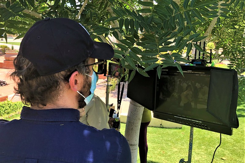
Attention to detail is critical throughout design and construction of the I-10 Broadway Curve Improvement Project. It’s also important as ADOT works to create awareness for drivers and others who’ll be impacted by three years of road work. Nowhere was that more evident than during production of the project’s TV commercials, which underscores the importance of having “good info.”

The TV spot - available in English and Spanish - begins with two friends playing chess in a park. One player captures the other player’s queen. He thinks he’s won the match until a young girl walks by, looks at the board and sees the winning move. She whispers a piece of advice into the second player’s ear.

Checkmate!

So what did she say to help the player win the game?

“E1 to E8,” explained local chess expert Josue ‘Sway’ Garcia, who was on set during the June 8 production in Scottsdale. “That meant he should move his rook to capture his opponent’s rook and force the checkmate.”

Garcia has been a chess aficionado for more than 25 years. In the last three years alone he’s logged nearly 40,000 matches on Chess.com, won 19,854 of them, and tied 807. On the production set, he was more than an extra playing chess in the background. His primary role was to verify the two players’ chess board was set up correctly and all the moves featured in the commercial are authentic.

In chess, losing a queen is “devastating,” Garcia said. But in this match, it created the opportunity for one move that signaled checkmate ahead.

Garcia said there’s another detail the keen-eyed chess enthusiast might notice on the board: Losing the queen was a blessing in disguise for the winning player.

“If he hadn’t lost his queen,” Garcia said, “he would have lost the match.”

Sure, details only chess players will notice; but making sure they were accurate was a priority for this production. Similarly, drivers and others might not notice or understand many of the details that go into reconstructing 11 miles of I-10 in the metro-Phoenix region. But they truly matter for the project to be a winner.

And, although ADOT can’t help you navigate a chess board, we can provide you with “good info” to navigate the construction zone on I-10. Visit i10BroadwayCurve.com; while you’re there, subscribe to receive project email alerts. Download the free mobile app, The Curve from the App Store or Google Play. You can also call 602.501.5505, email [email protected] or stop by the project office at 3157 E. Elwood Street, Suite 100, in Phoenix between 8 a.m. and 5 p.m. Mondays through Fridays.

Crews from two projects team up on improvement work, reduce need for additional closure

Crews from two projects team up on improvement work, reduce need for additional closure

SR24-1

Crews from two projects team up on improvement work, reduce need for additional closure

Crews from two projects team up on improvement work, reduce need for additional closure

By the Broadway Curve Project Team
September 29, 2021

The work zone ADOT is setting up this weekend will enable crews to build a better interchange at Interstate 10 and the US 60 (Superstition Freeway).

We’re getting the word out every way we can to alert drivers about this weekend’s full closures of the US 60 (Superstition Freeway) between Interstate 10 and Loop 101 (Price Freeway).

We also want to let drivers and others know how two Arizona Department of Transportation teams coordinated schedules to work on their projects at the same time, eliminating the need for another closure in the future.

The ADOT maintenance team already had US 60 scheduled to close in both directions this weekend between Loop 101 and Hardy Drive for pavement seal work. 

To reduce the number of times US 60 must be closed, ADOT scheduled a second project simultaneously over the weekend. 

For the I-10 Broadway Curve Improvement Project, crews will continue to remove rubberized asphalt from the road surface and set up the work zone between I-10 and Hardy Drive. The coordination effort between the two teams is allowing the work to get done at the same time, resulting in fewer impacts. 

We hope it’s some consolation that, while full freeway closures are sometimes necessary to advance a project or conduct repairs, piggybacking on the already scheduled US 60 closures means at least one less closure in the future. We hope drivers can get behind us on that. 

Don’t get thrown for a loop

Don’t get thrown for a loop

SR24-1

Don’t get thrown for a loop

Don’t get thrown for a loop

By the Broadway Curve Project Team
September 1, 2021

How many 202s does it take to make a detour? When it comes to construction on the I-10 Broadway Curve Improvement Project, the answer is one, two or sometimes all three.  

Metro Phoenix’s 101, 202 and 303 freeway loops make it easy to connect with all points of Greater Phoenix. But for the purpose of navigating around construction during the Broadway Curve Improvement Project, get used to hearing about the three sections of Loop 202 - the Red Mountain, Santan and South Mountain freeways, which run north, east and south of the construction zone. 

We’ll move clockwise, starting with the northern portion - the Red Mountain Freeway. Much of its 31 miles runs parallel to, and north of, Interstate 10 and US 60 (Superstition Freeway), and is the best bet for most people traveling to and from the East Valley. It will connect you to Arizona State University, Phoenix Sky Harbor International Airport, downtown Phoenix and beyond. Loop 202’s northern portion begins at the intersection of I-10 and State Route 51 just east of downtown Phoenix. At Power Road, Loop 202 turns south, and the freeway’s eastern portion begins. The Red Mountain section of the Loop 202 ends at US 60. 

The Santan Freeway picks up from here, continues south to Warner Road, then turns west until it meets up with I-10 25 miles later. At this point, drivers are beyond the project area and can continue to the West Valley or toward Tucson. The Santan Freeway connects the communities of Chandler, Gilbert, south Mesa and Queen Creek.  

The third and most recent addition to the Loop 202 system is the South Mountain Freeway, which connects the communities in the southeast and southwest valleys. Its 22 miles picks up at I-10, where the Santan ends, and continues west all the way around South Mountain Park along the southernmost part of Phoenix. It begins its northward bend near 35th Avenue and connects with I-10 again at 59th Avenue west of downtown Phoenix. The South Mountain Freeway provides an alternative to I-10 through downtown Phoenix for those headed to the West Valley or south toward Tucson. 

So don’t get thrown for a loop. Understanding the Loop 202 system will make driving around the Valley easier, even after the Broadway Curve Improvement Project is completed.

Want to learn more? Here’s a map of the other Valley freeway nicknames

Stay #AheadOfTheCurve and get the latest information on the I-10 Broadway Curve Improvement Project website and on social media.