Throwback Thursday

Throwback Thursday: Globe in the horse-and-buggy era

Throwback Thursday: Globe in the horse-and-buggy era

SR24-1

Throwback Thursday: Globe in the horse-and-buggy era

Throwback Thursday: Globe in the horse-and-buggy era

December 13, 2018

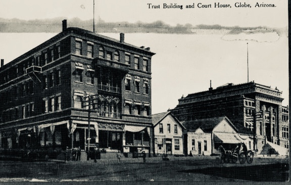
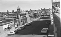
Trust Building and Court House, 1906

By David Woodfill / ADOT Communications

For this Throwback Thursday, we offer this undated, grainy image of the old commercial district of Globe, complete with a horse and buggy.

The photo is actually a copy of a postcard found on a negative in ADOT's archives. We can only assume it's from before or in the earliest days of the state highway system.

The trust building is long gone, but the courthouse still stands on Broad Street, part of which is now US 60. Designed by architect W.R. Norton, the Gila County Courthouse opened in 1906 and is now on the National Register of Historic Places.

Throwback Thursday: A friendly smile and helping hand at commercial ports

Throwback Thursday: A friendly smile and helping hand at commercial ports

SR24-1

Throwback Thursday: A friendly smile and helping hand at commercial ports

Throwback Thursday: A friendly smile and helping hand at commercial ports

November 1, 2018

Vintage photo of Truck at a commercial port

By Lauri Merrill / ADOT Communications

As this vintage photo of a smiling driver and a pleasant inspector illustrates, trucking has always been a vital part of Arizona commerce and a frequent sight on our roadways. To help facilitate commerce while keeping highway safe, ADOT's Enforcement and Compliance Division conducts safety inspections and handles permits at commercial ports of entry.

Whether it's Motor Vehicle Division officers back in the day, as shown in this week’s Throwback Thursday entry, or today with officers with ADOT's Enforcement and Compliance Division manning commercial ports of entry, this relationship is all about safety and supporting the economy.

The state-certified police officers with the Enforcement and Compliance Division focus on transportation issues including commercial vehicle enforcement, title, registration and driver’s license fraud, unlicensed auto dealers and commercial vehicle permits.

Using the Arizona Management System and its focus on improving value to customers, ADOT also is finding ways to make commercial ports even more effective. This includes efforts by our Border Liaison Unit to educate truckers and companies in Mexico on what is involved in ADOT safety inspections.

Those who complete the International Border Inspection Qualification can message ADOT inspectors via WhatsApp to find out whether a particular situation involving a truck needs to be addressed before coming to the commercial port. As a result of this program, instances in which qualified drivers have their trucks stopped for major issues have dropped to almost none.

These innovations help create congenial moments much like the one shown in the photo above.

Throwback Thursday: Making winter travel safer

Throwback Thursday: Making winter travel safer

SR24-1

Throwback Thursday: Making winter travel safer

Throwback Thursday: Making winter travel safer

September 27, 2018

Snowplow

By Laurie Merrill / ADOT Communications

The official end of monsoon season is just days away and ADOT is already planning for winter weather.

Like the mighty monsoons, Arizona’s winter storms can pack a powerful punch, covering highways with ice and snow.

This decades-old photo depicts ADOT crew members readying a plow for its winter purpose. Then, as now, it takes an army of ADOT crew members and a fleet of snowplows to make roads safe after winter storms.

Before the snow arrives, be sure to visit our Know Snow page.

Throwback Thursday: Driver license testing

Throwback Thursday: Driver license testing

SR24-1

Throwback Thursday: Driver license testing

Throwback Thursday: Driver license testing

September 6, 2018

MVD Test

By Laurie Merrill / ADOT Communications

As if the hairdos and outfits weren’t enough to date this era, driver license tests have also come a long way since this Arizona Department of Transportation Motor Vehicle Division photo was snapped decades ago. If, like me, you learned to drive in the days before computers, this photo of people sitting at classroom-style desks, complete with pencil holders, will look familiar.

Today, would-be licensees who take the 30-question, multiple-choice test do so at a computer using a touch screen. Audio assist is available.

In an even larger technological leap, teenagers hoping to get their learners permits are flocking to the Permit Test @ Home, a new online option that ADOT introduced earlier this year.

Some things don’t change. The way we take the tests reflects the electronic revolution, but the content still stems directly from the Arizona Driver License Manual. Serious studying is still required.

Throwback Thursday: Getting you up and over the Grand Canyon

Throwback Thursday: Getting you up and over the Grand Canyon

SR24-1

Throwback Thursday: Getting you up and over the Grand Canyon

Throwback Thursday: Getting you up and over the Grand Canyon

August 9, 2018

Grand Canyon Airport 1977

By David Rookhuyzen / ADOT Communications

Today we are throwing back more than four decades to right after we took over operation of ADOT's one and only airport.

These pictures of the Grand Canyon National Park Airport date from 1977, just three short years after ADOT began operating the single-runway airport in Tusayan. Technically the state has been overseeing operations more than 50 years, as originally it was under the jurisdiction of the Arizona Department of Aeronautics. The state took on the airport because Tusayan wasn't an incorporated community at the time.

The terminal that can be seen in the photo was just under a decade old at this point. And the 9,000-foot-long, 150-foot-wide runway, situated at a 6,600-foot elevation, wasn’t much older, having only been completed a couple years before that. Folks may notice there is no FAA control tower in the photo, unlike what visitors will see today (that wouldn’t go up until 2003).

2018-0809-2grand-canyon-airport-1977

Airplane in 1977

The airport now provides facilities for different tourism companies and has added a fire station, among other changes.

What is still recognizable today is what the plane at right represents: the Grand Canyon aerial tourism industry. Aviation technology may have changed in the past 41 years, but people are still flocking to the area to see Arizona’s natural wonder from the sky. Grand Canyon National Park Airport served more than 325,000 people in 2016 alone and is one of the four busiest airports in the state.

Throwback Thursday: In Flagstaff of 1966, parking was no sport

Throwback Thursday: In Flagstaff of 1966, parking was no sport

SR24-1

Throwback Thursday: In Flagstaff of 1966, parking was no sport

Throwback Thursday: In Flagstaff of 1966, parking was no sport

April 5, 2018

By Laurie Merrill / ADOT Communications

In 1966, when the large steel-and-chrome cars of the era took up more space, there was still plenty of parking in downtown Flagstaff, as shown in this ADOT photo offering a slice of life along Birch Avenue east of Leroux Street.

Styles were different then. The men in crew cuts on the rooftop in the afternoon sun clearly liked their hair short, while the Pontiacs, Chevrolets and Fords on the street below showed they liked their cars long.

Also different was the one-way direction of Birch Avenue, which now runs westbound instead of eastbound, as it did in 1966.

The McLellan's five-and-dime store in the foreground is no longer part of the scene – that building is now home to restaurants and shops. The same goes for the First Federal Savings building.

The Coconino County Courthouse, however, has been a fixture on the corner of San Francisco and Birch since its construction in 1894.

Why was this photo in the ADOT archives? Well, we aren't exactly sure. The 1966 telephone directory's entry for the Arizona Highway Department (our former name) doesn't list an address in that area of Flagstaff. But we thought you'd enjoy the photo nonetheless.

Throwback Thursday: SR 179 Red Rock Scenic Byway

Throwback Thursday: SR 179 Red Rock Scenic Byway

SR24-1

Throwback Thursday: SR 179 Red Rock Scenic Byway

Throwback Thursday: SR 179 Red Rock Scenic Byway

March 29, 2018

By David Woodfill / ADOT Communications

Although one could never tell from this old black-and-white photo, State Route 179 came to be known as the Red Rock Scenic Byway for its majestic red buttes composed of iron-rich sediment that formed over millions of years.

Motorists, like the lucky owner of that Datsun 240z, can drive this meandering stretch of highway while taking in some of the most breath-taking views in our state.

The highway stretches about 15 miles between Interstate 17 north of Camp Verde to Sedona.