US-89

Detours offer access to northern Arizona communities, businesses near US 89 closure

Detours offer access to northern Arizona communities, businesses near US 89 closure

SR24-1

Detours offer access to northern Arizona communities, businesses near US 89 closure

Detours offer access to northern Arizona communities, businesses near US 89 closure

April 2, 2013

Even though there’s a stretch of US 89 that’s not open, the businesses and communities surrounding the closure most definitely are.

That’s the message that area residents, business owners and ADOT are hoping to get out…

“With the busy tourism season coming up, there are a lot of people concerned in Page and the Lake Powell area with how this closure is going to impact their businesses,” says ADOT Public Information Officer Dustin Krugel in the video above. “That’s why we’re doing everything we can to let the public know that Page and the Lake Powell area are open.”

Motorists should know that they can still get to all the popular tourism destinations in the northern part of our state.

Traci Varner, general manager at the Lake Powell Days Inn, says the detour is actually really a pretty drive.

“It’s just a little out of the way, but it’s a beautiful ride,” she says.

It’s also important to note that US 89A is not affected by the closure. So if you’re heading to the Grand Canyon's north rim (when it opens up for the season in mid-May), Fredonia, Lees Ferry or Marble Canyon, the detour won't impact your drive.

So, to sum up … Page and the Lake Powell areas are open for business. And, judging from the video above, they’re all ready for the beautiful season ahead!

ADOT plans shorter detour for highway closed by landslide south of Page

ADOT plans shorter detour for highway closed by landslide south of Page

SR24-1

ADOT plans shorter detour for highway closed by landslide south of Page

ADOT plans shorter detour for highway closed by landslide south of Page

March 22, 2013

A copy of the map included in yesterday's
State Transportation Board meeting agenda.

We’ve got some good news for drivers whose commutes have been impacted by the US 89 landslide...

At a special meeting of the State Transportation Board yesterday, the board approved $1 million to design improvements to Navajo Route 20, a Navajo Nation tribal road that runs parallel to the damaged highway.

That means ADOT is a step closer toward establishing a shorter detour route for those drivers who travel daily to Page and the Lake Powell area.

While not a long-term solution, this will help the thousands of motorists who are inconvenienced daily by the unscheduled detour caused by last month’s landslide.

“ADOT has been working with the Navajo Division of Transportation, the Navajo Nation and the Bureau of Indian Affairs to pave N20 as an interim measure to shorten the detour route between Flagstaff and Page,” said Dallas Hammit, ADOT deputy state engineer of development. “With assistance from the Federal Highway Administration, we are looking to use federal emergency relief funds to restore essential traffic in the region, while we work on the ultimate repair on US 89.”

As part of ADOT’s plans to improve the existing 44-mile-long tribal route, which is mostly a dirt road stretching from Bodaway-Gap to LeChee, ADOT would designate the road as Temporary US 89 (US 89T).

ADOT would pave the road and ensure that it could carry commercial truck traffic, while repairs are made to US 89. The agency is already working with potential contractors and construction could begin as soon as late spring.

The project is expected to take three to four months to complete.

The ability to pave Navajo Route 20 is contingent upon agreements being reached with several stakeholders, including the Navajo Division of Transportation, the Navajo Nation, the Bureau of Indian Affairs and the Federal Highway Administration.

After the reconstruction of US 89 is complete, the road will be relinquished to the Navajo Nation. There is no timetable for reopening the highway, but ADOT is committed to restoring this important travel route as soon as safely possible.

Now that we've got your attention...

Now that we've got your attention...

SR24-1

Now that we've got your attention...

Now that we've got your attention...

March 8, 2013

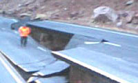
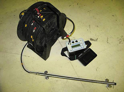
ADOT worker standing next to road damage from the landslide.

By Nicole Sherbert
ADOT Assistant Communication Director


It would be an understatement to say that we’ve experienced a bit of a surge in our social media audience of late.

Those of us who have spent the last few years working to build ADOT’s online network would love to believe that our spontaneous increase in viewers, followers and readers is due solely to our engaging content and commitment to transparency…

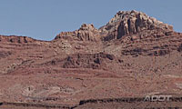
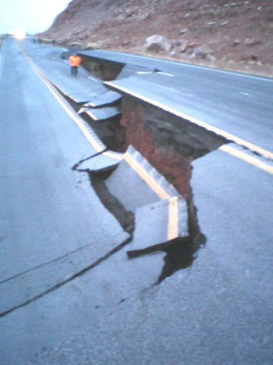
Or, it might have something to do with the photo to the right.

If you’re reading today’s blog post, chances are you are at least familiar with the context of this photo, but just in case, a quick recap:

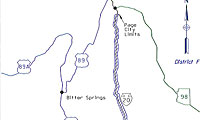
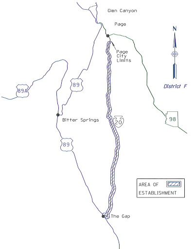
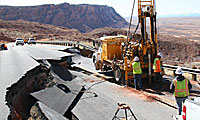
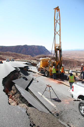
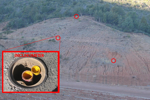
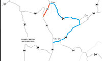
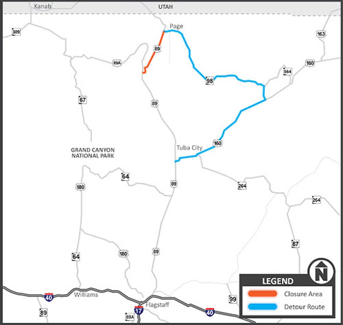
On Feb. 20, a landslide ripped through the mountainside at US 89 in northern Arizona about 25 miles south of Page forcing ADOT to immediately and indefinitely close the highway – a major travel route in an area where – to use engineer speak – there is little redundancy of travel routes.

To help spread the word of the road closure and evolving situation, we immediately took to our social media outlets, starting with tweeting and posting to Facebook the photo above. Within two hours, that single photo had been shared and retweeted nearly 1,000 times. Within 24 hours, the shares of that and related photos climbed to more than 6,000 – leading to a Facebook estimated one-week reach of nearly 400,000 users.

Within 24 hours, a YouTube video explaining the situation had been viewed 5,000+ times. To date, it and two subsequent videos have been viewed close to 50,000 times.

But why does this matter? Sure, they were dramatic photos, but outside of the wow factor, what’s the point?

The simple answer is to rapidly spread important information.

While US 89 is a rural road in a relatively remote part of the state, an average of 5,000 people a day travel that stretch of highway and traffic increases dramatically in the coming weeks when folks around the world head to Lake Powell and nearby national parks and monuments.

So how do we reach people to get the word out that motorists should expect a detour but that Page and the surrounding areas are still open for business? By reaching out to a network broader than just our own.

And this is when social media is at its best…when users serve as real-time information sources to reach an extended, networked audience.

But, what now? 

If you are one of the 1,600 people who “liked” us on Facebook the week of Feb. 20, I’m guessing that leading up to seeing those photos you may not have even known ADOT had a Facebook page, more or less a blog and YouTube channel. And while we can’t tell you how much we wish it was under different circumstances, we’re glad you found us and hope you stay engaged.

We’ll continue to provide updates about US 89, but we have a lot of really important information to share and we hope you’ll continue to help us spread the word. Here are three great ways to start:

  1. Yesterday, we blogged about ADOT’s tentative Five-Year Construction Program and asked you to provide comment. And while it lacks the drama of a quarter-mile landslide, it is your opportunity to have your voice heard about the future of your Arizona highway system.
  2. Do you, or anyone you know, travel in southern Arizona? Then you might want to share this blog post from Monday explaining that a bridge removal in southern Arizona will necessitate the closure of I-10 south of Tucson for about nine hours tonight. (And the only way around is a 67-mile detour.)
  3. On Monday we will be launching a new public safety campaign aimed at protecting the lives of everyone who drives or works on Arizona roadways. And while we’re still putting some final touches on the website, we thought we’d give you a sneak peek just for being a loyal blog follower.

If you’re new to our social media network, we hope you’ll stick around, ask us questions and continue to share our information. And for those who have been around for a while and helped us build our social media foundation, thank you.

ADOT granted $2 million in immediate federal aid to investigate US 89 landslide

ADOT granted $2 million in immediate federal aid to investigate US 89 landslide

SR24-1

ADOT granted $2 million in immediate federal aid to investigate US 89 landslide

ADOT granted $2 million in immediate federal aid to investigate US 89 landslide

March 6, 2013

Find more US 89 photos HERE.

After seeing the photos and video of US 89, it’s obvious that a lot of engineering brainpower will be needed to determine the cause of the landslide and what the possible long- and short-term options might be. Seeing the magnitude of the damage might also make you wonder about costs...

Immediate federal aid

ADOT has been granted $2 million in immediate federal aid that can be used to continue investigating the cause of the landslide.

Following Governor Jan Brewer’s Declaration of Emergency last week, ADOT asked the Federal Highway Administration for the quick release of emergency relief funds and submitted an initial estimate to complete repairs of $35 million. This estimate may change as further information about the landslide is gathered by engineers.

The quick release funds will be used to assess the damage and the stability of the mountain slope, and conduct emergency operations.

The Federal Highway Administration’s emergency relief program reimburses state and local agencies for the repair or reconstruction of highways, roads and bridges that are damaged in natural disasters and catastrophic failures.

“Our budget for emergencies is very limited, and local governments have even greater financial constraints with limited cash available to fund emergencies,” said Jennifer Toth, ADOT deputy director for transportation. “This initial allocation serves as a down payment on the overall emergency relief needs for US 89. It will offset the cost for the geotechnical investigation of the landslide area to determine short- and long-term options.”

ADOT is currently conducting a geological investigation to determine the stability of the mountain slope in the Echo Cliffs. The agency is also performing damage assessments in the area and a more accurate estimate will be available in the future.

Transportation Defined: Inclinometers

Transportation Defined: Inclinometers

SR24-1

Transportation Defined: Inclinometers

Transportation Defined: Inclinometers

February 27, 2013

An inclinometer measures slope
inclination at a specific location.

If you've been following our US 89 updates on Facebook or YouTube you know that we have been talking a lot about geotechnical engineers lately. Today, we want to take a look at one of the tools they work with: inclinometers.

***

When engineers suspect a slope or embankment might be moving, they can use an inclinometer to see if their hunch is correct…

But, what’s an inclinometer?

An inclinometer is a device that measures the slope inclination (movement) at a specific location.

ADOT Geotechnical Operations Manager J. J. Liu explains that an inclinometer consists of a precision-tooled plastic casing (it looks basically like PVC pipe) that has internal grooves carved out of it.

That casing is installed into the ground through a vertically drilled hole.

Next, the casing is weakly grouted into place, allowing it to shift with the ground when (or if) it moves. A probe (not just any probe – this one measures tilt and can calculate the magnitude, direction and scope of any ground movement) is then inserted into the casing in order to measure the inclination at various points along the length of the casing.

“The inclination data is compiled and compared with a baseline reading, which we obtain right after the inclinometer is installed,” Liu says. “The difference at each elevation is the magnitude and direction of the movement at that elevation.”

We mentioned the internal grooves above and we don’t want to forget about those…

2013-0227-inclinometer2

Inclinometers out in the field.

The grooves are on the inside of the casing and serve as a kind of track for the inclinometer probe (the probe has guiding wheels – did we mention that? You can see them in the photo above).

So, the wheels sit in the grooves and measurements of the inclinations at various points are taken by the unit as the probe is pulled up from the bottom of the casing.

Hopefully this is making sense, but if not, try to picture a big milkshake (it can be any flavor!).

We’ll say it’s a very thick milkshake … thick enough that you can drill a hole through the ice cream, all the way down to the bottom of your glass. Now imagine sticking a big straw down that hole that you’ve just drilled out.

The straw is kind of like the casing that we described above. If the milkshake moves or shifts a little bit, the straw is going to move along with it.

There’s no real food analogy to go with this next part, so we’ll just say that you’ll place a probe (that same sophisticated probe we described earlier – the one with the wheels that can calculate the scope and direction of any movement) down the hole of the straw…

You’ll use the probe to take periodic readings and, over a period of time, you’ll know how much your shake is shifting.

Transportation Defined is a series of explanatory blog posts designed to define the things you see on your everyday commute. Let us know if there's something you'd like to see explained ... leave a comment here on the blog or over on our Facebook page!


Buckled pavement closes US 89 south of Page

Buckled pavement closes US 89 south of Page

SR24-1

Buckled pavement closes US 89 south of Page

Buckled pavement closes US 89 south of Page

February 21, 2013

By now, many of you have probably already seen photos of US 89 …

A 150-foot section of the road “buckled” yesterday morning (Feb. 20) in an area about 25 miles south of Page – the cause of the highway damage may have been a geologic event.

While it will take a while to assess what happened and figure out how to fix it, we can tell you now that ADOT is currently conducting a geotechnical analysis that will determine the scope of highway repairs to be made.

Once a determination is made, ADOT will utilize emergency contract procedures to restore the highway.

For the foreseeable future, the section of US 89 will remain closed in both directions between US 89A, which takes motorists west toward Jacob Lake, and the US 89 junction with SR 98 in Page.

US 89 buckled pavement closure.

Motorists will use an alternate route to and from Page while this section of US 89 remains closed. That alternate route detours motorists on US 160 to SR 98, which is about 45 miles longer than the direct route (see map for detour).

Moving forward

ADOT funds will be used to cover the repair costs. At a future date, ADOT will seek reimbursement for the repair costs through the Federal Highway Administration Emergency Repair Program. The reimbursement process does not hinder action to repair the highway.

Keep informed
If you would like to receive email updates on US 89, you can subscribe online.

We will continue to provide updates as information is available here on the blog, on Facebook and on Twitter. As always, drivers can get details on highway and traffic conditions statewide at az511.gov.