‘The most spectacular and expensive project of its kind ever attempted in Arizona’
‘The most spectacular and expensive project of its kind ever attempted in Arizona’
“Let there no longer be any north, south, east or west in Arizona, but one glorious state tied together by ribbons of road.”
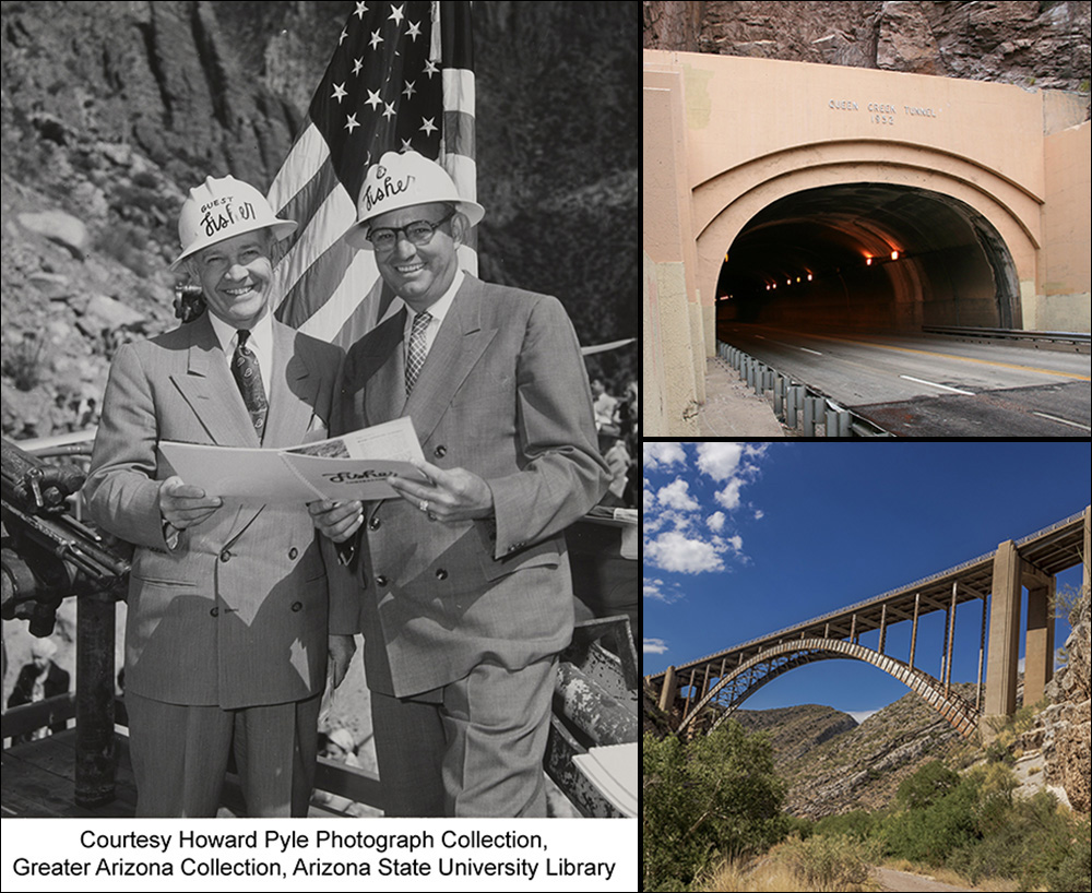
With those words, spoken on May 16, 1953, Arizona Gov. J. Howard Pyle cut a ribbon to officially open the 1,217-foot-long Queen Creek Tunnel and 577-foot-long Queen Creek Bridge. Standing at left in the photo above, Governor Pyle was outside the tunnel’s western entrance on the Superior-Miami Highway, which at that time was designated US 60/70. Framing him was the roadway’s reconfigured path high above the canyon floor and descending 1.5 miles to Superior.
 Thousands, including New Mexico Gov. Edwin L. Mechem and representatives from seven other states, gathered to celebrate what the Arizona Daily Star called “the most spectacular and expensive project of its kind ever attempted in Arizona.” The Valley’s KOY Radio recorded the proceedings to air that night at 8.
Motorcades that started in New Mexico and grew as they went along carried representatives from communities lining US 60 and US 70. Others came from as far away as Nogales, Sonora. According to an account by The Associated Press, vehicles flowed through the tunnel in rows of four, honking horns as they went, to start the proceedings. Governor Pyle led a group traveling from Show Low after a meeting of the National U.S. Highway 60 Association.
What made this nearly $3 million improvement worthy of such attention and Homeric language? The answer still lies downhill. A major realignment featuring the tunnel and bridge replaced the narrow, 300-foot Claypool Tunnel that had been in use since 1926, along with a steep, winding stretch of road that traveled along the canyon bottom into and out of Superior. The work capped about $5 million of investments to create a modern highway between Superior and Miami.
 US 60 and US 70 were critical arteries at a national level before the Interstate Highway System, making the Superior-Miami Highway critical to connecting Arizona with points east. As they still do today, the two highways converged in Globe from the east – US 70 through Duncan and Safford, US 60 through Springerville and Show Low – leaving the route through Superior the most direct link with the Phoenix area and points west. This 1946 map posted by the Arizona Memory Project provides a good idea of how Arizona highways looked in 1953.
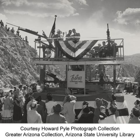
That’s what drew so many to this spot just uphill from Superior, which hosted a two-day fiesta after the ribbon-cutting. The photo at upper right shows people assembling for the dedication. The photo below it shows what attendees saw when they weren’t gawking at the tunnel: a raised platform that held Governor Pyle and VIPs such as Del W. Fisher (that’s him with Governor Pyle atop this post) of Fisher Contracting Co., which built the tunnel and bridge.
Governor Pyle dedicated the improvements to “the safe, sober and sensible youth of America,” according to the AP.
The Queen Creek Tunnel was Arizona’s longest when it opened, but the 1,400-foot-long State Route 80 Mule Pass Tunnel near Bisbee took over the top spot when it opened in 1958. (Note: The Interstate 10 Deck Park Tunnel near downtown Phoenix is 2,582 feet long, but it’s technically a series of bridges.) Drilling for the Queen Creek Tunnel began in July 1950, and the completed tunnel was reinforced and lined with concrete. It opened with one downhill lane and two lanes going up the 6% grade, an innovative approach in its day to accommodate trucks and slower passenger vehicles.
 The Queen Creek Bridge, shown at bottom right as it looks today, is almost an exact replica of the Pinto Creek Bridge completed a few years before about 10 miles to the east on US 60/70. It has a main span of 384 feet and features a dramatic steel arch. You can see the bridge it replaced and the old roadway far below on the canyon bottom.
The Queen Creek Tunnel continues to pay dividends for those traveling what now is just US 60 between the Valley and Globe, getting upgrades along the way such as LED lighting. We have lots of photos of the tunnel in this Flickr album from 2015, before the lighting upgrade. You’ll see 1952 atop the tunnel entrance, but traffic started using the tunnel in late February 1953.
Time is less kind to bridges. That’s why, 70 years after the dedication, ADOT is readying a project to build a new Queen Creek Bridge. ADOT also will replace the Waterfall Canyon Bridge east of the tunnel. The work is scheduled to begin early next year, adding to recent improvements including the new Pinto Creek Bridge and a westbound climbing lane between Devil’s Canyon and Oak Flat (mileposts 233-231).
Investing in US 60 is one way ADOT continues to deliver on Governor Pyle’s vision of “one glorious state tied together by ribbons of road.”