Southeast

I-10: East Willcox Traffic Interchange Bridge Rehabilitation Project

I-10: East Willcox Traffic Interchange Bridge Rehabilitation Project

I-10: East Willcox Traffic Interchange Bridge Rehabilitation Project

I-10: East Willcox Traffic Interchange Bridge Rehabilitation Project

Overview

The Arizona Department of Transportation has initiated a rehabilitation project at the Interstate 10 and Willcox Traffic Interchange Bridge at milepost 344.5 in Cochise County. This project will extend the overall service of life for the bridge.

Project Elements

  • Improving the condition of the existing bridge deck 

Project Schedule

Construction is scheduled to begin February 2025 and is expected to take approximately two months to complete.

Schedules are subject to change due to weather and other unforeseen circumstances.

Project Area Map

I-10: East Willcox Traffic Interchange Bridge Rehabilitation Project map

What to Expect

This project will involve a full closure of the bridge for the duration of the project. Exit 344 for westbound I 10 will be closed and motorists will be detoured to Exit 340 towards Fort Grant Road and Rex Allen Drive. Eastbound I-10 motorists will continue to have access to Exit 344 towards Haskell Avenue.

Stay Informed

...

Subscribe to receive project updates and traffic alerts by email. For more information, please call the ADOT Bilingual Project Information Line at 855.712.8530 or submit a question or comment by email.  For real-time highway conditions statewide, visit ADOT’s Traveler Information Site at www.az511.gov, follow ADOT on Twitter @ArizonaDOT or call 511, except while driving.

US 191: Table Top Road Pavement Rehabilitation

US 191: Table Top Road Pavement Rehabilitation

US 191: Table Top Road Pavement Rehabilitation

US 191: Table Top Road Pavement Rehabilitation

Overview

The Arizona Department of Transportation is completing a pavement rehabilitation project located in Greenlee County on US 191 between milepost 160 and 173 near the Town of Clifton. This project started July 2024 and is expected to continue until summer 2025.

Project Area Map

Map US 191: Table Top Road Pavement Rehabilitation

Project Elements

  • Applying a two-pass micro-surface on existing asphalt. 
  • Replacing pavement markings. 
  • Implementing pavement spot repairs.

Project Schedule

  • Construction started July 2024 with guardrail replacement 
  • Crews began paving fall 2024
  • Project expected to be completed summer 2025

What to Expect

  • Lane closures are anticipated. In areas along US 191 that are two lanes,  a flagging operation will be utilized to direct traffic. 
  • Drivers should prepare for up to 2-mile delays when passing through the work area. 

ADOT will provide advance notice of restrictions and closures to email subscribers and on the project traffic alert web page

Stay Informed!

Subscribe to receive project updates and traffic alerts by email. For more information, please call the ADOT Bilingual Project Information Line at 855.712.8530 or [email protected].  For real-time highway conditions statewide, visit ADOT’s Traveler Information Site at www.az511.gov, follow ADOT on Twitter @ArizonaDOT or call 511, except while driving.

US 191: Armory Road to US 70

US 191: Armory Road to US 70

US 191: Armory Road to US 70

US 191: Armory Road to US 70

This Project Is Complete

Overview

The Arizona Department of Transportation has completed a pavement rehabilitation project in Safford from milepost 117 (near Old Country Club Road) to milepost 121 to improve the condition of the roadway. NOTE: the project did not include work at the US 191 and US 70 intersection. 

Project Area Map

US 191: Armory Road to US 70 Map

Project Elements

  • Removed existing asphaltic concrete and replaced it with new asphaltic friction course pavement
  • Reconstructed driveways
  • Installed new pavement markings

Project Schedule

Construction began July 2024 and the work was completed in November 2024.

Stay Informed

...

Subscribe to receive project updates and traffic alerts by email. For more information, please call the ADOT Bilingual Project Information Line at 855.712.8530 or email [email protected].  For real-time highway conditions statewide, visit ADOT’s Traveler Information Site at www.az511.gov, follow ADOT on Twitter @ArizonaDOT or call 511, except while driving.

US 191: Roundabout at SR 75 & SR 78

US 191: Roundabout at SR 75 & SR 78

US 191: Roundabout at SR 75 & SR 78

US 191: Roundabout at SR 75 & SR 78

OVERVIEW

The Arizona Department of Transportation is constructing a roundabout at the intersection of US 191, SR 75, and SR 78 located near Safford. This project will relieve traffic backups, improve sight distance, and reduce accidents.

US 191 Roundabout Project map


PROJECT ELEMENTS

  • Replacing existing two way intersection with a roundabout
  • Improving drainage and signage

PROJECT SCHEDULE

The project began in May 2024. Construction is expected to be completed by June 2025..

WHAT TO EXPECT

ADOT advises drivers to prepare for flagging operations to help drivers navigate through the construction site. Please allow extra travel time as traffic back ups are expected to be approximately half a mile in length. ADOT will provide advance notice of restrictions and closures to email subscribers and on the project traffic alert web page

Stay Informed!

Subscribe to receive project updates and traffic alerts by email. For more information, please call the ADOT Bilingual Project Information Line at 855.712.8530 or email [email protected]. For real-time highway conditions statewide, visit ADOT’s Traveler Information Site at www.az511.gov, follow ADOT on Twitter @ArizonaDOT or call 511, except while driving.

US 191: SR 266 to SR 366 Pavement Preservation

US 191: SR 266 to SR 366 Pavement Preservation

US 191: SR 266 to SR 366 Pavement Preservation

US 191: SR 266 to SR 366 Pavement Preservation

Overview

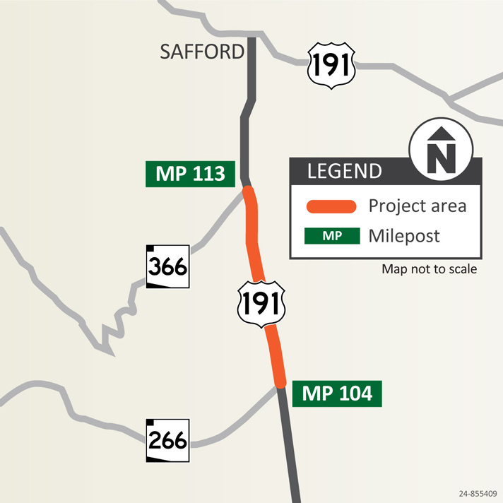
The Arizona Department of Transportation began work in late March on a pavement preservation project on US 191 between State Route 266 and SR 366 (mileposts 104 to 113) south of Safford.

Project Area Map

Project Map US 191: SR 266 to SR 366 Pavement Preservation

Project Elements

  • Rehabilitating the bridge deck overlay
  • Repaving roadway and shoulders
  • Installing guard rails
  • Reapplying pavement markings

Project Schedule

Construction is expected to be complete by summer 2024. Schedules are subject to change because of weather and other unforeseen factors.

What to Expect

Work is scheduled from 6 a.m. to 6 p.m. Monday through Friday. One lane will be open to traffic with a pilot car to lead drivers through the construction zone.

Restrictions and Closures

 For real-time highway conditions statewide, visit ADOT’s Traveler Information Site at www.az511.gov, follow ADOT on Twitter @ArizonaDOT or call 511, except while driving.

Remember to slow down and use caution around construction workers and equipment.

Stay Informed!

...
  • Phone: Call the ADOT Bilingual Project Information Line at 855.712.8530
  • Teléfono: Línea de Información del Proyecto ADOT: 855.712.8530
  • By mail: ADOT Community Relations, 1221 S. Second Ave., Tucson, AZ 85713

US 191 and Interstate 10: Bridge Repair

US 191 and Interstate 10: Bridge Repair

US 191 and Interstate 10: Bridge Repair

US 191 and Interstate 10: Bridge Repair

This project is complete

Overview

The Arizona Department of Transportation has completed a project to repair the US 191 overpass at Interstate 10 near milepost 331 in Cochise County that was damaged due to an accident during the summer of 2023.

Project Fact Sheet

Project Area Map

US 191 Interstate 10 Bridge Repair Map

Project Schedule

  • The $5.3 million project is now complete after work began early 2024 to demolish the US 191 bridge and then rebuild the superstructure, which includes the girders and deck.

Project Photos

Project Photo US 191 and Interstate 10: Bridge Repair

Stay Informed

...

Subscribe to receive project updates and traffic alerts by email. For more information, please call the ADOT Bilingual Project Information Line at 855.712.8530 or submit a question or comment by email.  For real-time highway conditions statewide, visit ADOT’s Traveler Information Site at www.az511.gov, follow ADOT on Twitter @ArizonaDOT or call 511, except while driving.

State Route 10B and SR 186 Pavement Rehabilitation Project: Arizona Avenue to Rex Allen Road

State Route 10B and SR 186 Pavement Rehabilitation Project: Arizona Avenue to Rex Allen Road

State Route 10B and SR 186 Pavement Rehabilitation Project: Arizona Avenue to Rex Allen Road

State Route 10B and SR 186 Pavement Rehabilitation Project: Arizona Avenue to Rex Allen Road

Overview

The Arizona Department of Transportation completed a pavement rehabilitation project on State Route 10B in Willcox between Arizona Avenue and Rex Allen Drive (mileposts 339 to 340) and SR 186 between mileposts 326 and 327.

Project Area Map

Project Area: State Route 10B and SR 186 Pavement Rehabilitation Project: Arizona Avenue to Rex Allen Road

Project Elements

Key element of the project include:

  • Reconstructing driveways
  • Installing new sidewalks 
  • Replacing existing asphalt with new asphalt 
  • Completing new pavement markings

Project Schedule

Work began August 2023 on the sidewalks, ramps, and driveways. Pavement rehabilitation began April 2024 and was completed in May 2024. 


Stay Informed

...

For more information and to subscribe to project updates by email, please visit the project web page at:

Pursuant to Title VI of the Civil Rights Act of 1964, the Americans with Disabilities Act (ADA) and other nondiscrimination laws and authorities, ADOT does not discriminate on the basis of race, color, national origin, sex, age, or disability. Persons that require a reasonable accommodation based on language or disability should contact Tara Gibson at [email protected] or 855.712.8530. Requests should be made as early as possible to ensure the State has an opportunity to address the accommodation.

De acuerdo con el Título VI de la Ley de Derechos Civiles de 1964, la Ley de Estadounidenses con Discapacidades (ADA por sus siglas en inglés) y otras normas y leyes antidiscriminatorias, el Departamento de Transporte de Arizona (ADOT) no discrimina por motivos de raza, color, origen nacional, sexo, edad o discapacidad. Las personas que requieran asistencia (dentro de lo razonable) ya sea por el idioma o discapacidad deben ponerse en contacto en Tara Gibson [email protected] o 855.712.8530. Las solicitudes deben hacerse lo más antes posible para asegurar que el Estado tenga la oportunidad de hacer los arreglos necesarios.

ADOT Tracs: F047401C

State Route 88 (Apache Trail)

State Route 88 (Apache Trail)

State Route 88 (Apache Trail)

State Route 88 (Apache Trail)

Overview

ADOT has reopened the 5-mile unpaved section of State Route 88 (Apache Trail) from Fish Creek Vista (milepost 222) to milepost 227 near Reavis Trailhead Road that was closed due to extensive roadway damage and rock debris following severe flooding in 2019.

The Woodbury Fire in June 2019 consumed almost 124,000 acres of the Tonto National Forest. In September 2019, a storm dumped approximately six inches of rain onto the fire scar and the runoff severely damaged large portions of the road, with the most damage being in the area between the Fish Creek Vista and milepost 227 (near Reavis Trailhead Road). The damage included a large rockslide that left that section of the road unpassable.

Map of SR 88


UPDATE

ADOT has completed the interim project to reopen State Route 88 (Apache Trail) from Fish Creek Vista (milepost 222) to milepost 227 near Reavis Trailhead Road.

ADOT invested $4 million for an interim project to restore limited access to five miles of SR 88 damaged by flooding in 2019, as it seeks funding for more extensive improvements needed to make the roadway more resilient and accessible long-term.

This interim plan was presented to the State Transportation Board at its Jan. 12, 2024, meeting and will restore the unpaved roadway to a condition that can accommodate vehicles with high clearance or four-wheel drive, as well as utility terrain vehicles. ADOT's interim plan called for removing boulders on Fish Creek Hill, mitigating rockfall as needed between Fish Creek Vista and Fish Creek Bridge (mileposts 222-223.5), making repairs to retaining walls, installing new signage, cleaning and potentially replacing damaged drainage culverts and taking other steps to safely reopen the highway for high clearance or four-wheel drive vehicles.

Maintenance crews worked on preliminary items ahead of the construction project like removing vegetation, filling in eroded areas in the road surface and cleaning out culverts. Contracted construction work began this summer. The U.S. Forest Service reviewed and approved the interim project design, since SR 88 follows an easement through federal land. In addition, the project was designed to meet all applicable state and federal environmental requirements.

2023 Study

In October 2023 ADOT completed a study, which recommended $33.7 million in improvements to make SR 88 more accessible and resilient to severe weather. Those improvements, developed with extensive public involvement and identified in a Design Concept Report, include:

  • Chip sealing, in which aggregate is compacted into heated asphalt liquid to create a more durable road surface, throughout the 5 miles.
  • Widening the roadway to 15 feet in steeper areas.
  • Increasing drainage capacity to accommodate heavier rainfall.
  • Rehabilitating or repairing existing bridges.
  • Adding pullouts and other safety enhancements.

This longer-term plan does not have dedicated funding, and ADOT is pursuing federal funding to advance these longer-term improvements.

Background

State Route 88/Apache Trail was constructed in 1904 to provide construction access for the Roosevelt Dam, which was completed in 1911. Much of the route, particularly east of Tortilla Flat, retains its original historic character.

aerial overview of SR 88

Aerial overview of SR 88.

SR 88 Apache Trail

Damage to SR 88 caused by the Woodbury Fire.


For More Information

...

Subscribe to receive project updates and traffic alerts by email. For more information, please call the ADOT Bilingual Project Information Line at 855.712.8530 or submit a question or comment by email to [email protected]

For real-time highway conditions statewide, visit ADOT’s Traveler Information Site at www.az511.gov, follow ADOT on Twitter (@ArizonaDOT) or call 511, except while driving.

US 60: Queen Creek and Waterfall Canyon Bridges Project

US 60: Queen Creek and Waterfall Canyon Bridges Project

US 60: Queen Creek and Waterfall Canyon Bridges Project

US 60: Queen Creek and Waterfall Canyon Bridges Project

Overview

The Arizona Department of Transportation is replacing the Queen Creek and Waterfall Canyon bridges located on US 60 between mileposts 227 and 229.5, just east of Superior in Pinal County.

A new Queen Creek Bridge will be constructed just to the east of the existing bridge, and the existing steel bridge will be removed following construction of the new bridge. The Waterfall Canyon Bridge, located east of the Queen Creek Tunnel, will be reconstructed into two box culverts to improve drainage, and will remain in its existing location.

Guardrail replacement and other general maintenance work will also be completed within and near the Queen Creek Tunnel.


US 60 Queen Creek Bridge
Queen Creek Bridge

US 60 Queen Waterfall Canyon
Waterfall Canyon Bridge

Project Map

Project Map - Queen Creek and Waterfall Canyon bridge projects


FAQs

Why does ADOT need to build the new bridges?

The Queen Creek Bridge, built in 1949, and the Waterfall Canyon Bridge, built in 1929, were built to standards in those times; however those standards no longer meet the current minimum bridge guidelines of ADOT or the Federal Highway Administration and the American Association of State Highway Transportation Officials. ADOT has completed multiple maintenance projects on the bridges to extend their lives; however due to weather and continued traffic-induced vibrations, the structures have reached the end of their useful lives.

What is the project timeline?

Construction of access roads to the project site in the canyon located below the Queen Creek Bridge began in early 2024. Work on the bridge is scheduled to begin after construction of the access roads is complete. The project is expected to last approximately two and a half years.

What type of traffic impacts should drivers expect during construction?

Drivers should expect occasional restrictions and closures of US 60 in the work zone during certain work, such as rock blasting. Closures will be limited to Tuesday, Wednesday and Thursday from 9 a.m. to 2 p.m in the early phases of the project. ADOT will notify the public in advance when specific restrictions or closures are planned and the project team will set up message boards on the US 60 in advance. Subscribe to receive traffic alerts and project updates by email.

What is the detour when US 60 is closed?

During full closures of US 60, ADOT will detour traffic onto State Route 77 and State Route 177. However, due to the length of this detour (approximately 75 miles) drivers might want to consider planning travel before 9 a.m. and after 2 p.m.

What are the recreational access restrictions?

The two bridges are located in an area frequented by hikers, rock climbers and other recreational users. For the safety of recreational users and the work crews, areas within and near the work zones are restricted during construction.

Waterfall Canyon Bridge area - The US 60 pull-out east of the Queen Creek tunnel nearest the Waterfall Canyon Bridge is closed during Waterfall Canyon Bridge reconstruction. Other nearby pull-outs may close intermittently based on the contractor’s staging needs. In addition, the area near the bridge will be inaccessible due to construction work.

Queen Creek Bridge area - The Lost Trail is closed through the project site during construction from the Magma Avenue Trailhead in Superior to the west of the historical Claypool Tunnel.

Project Photos and Video

US 60 queen creek and waterfall canyon bridges project photo roads
US 60 queen creek and waterfall canyon bridges project photo bridge wires
US 60 queen creek and waterfall canyon bridges project photo overlook
US 60 queen creek and waterfall canyon bridges project photo excavator
US 60 queen creek and waterfall canyon bridges project photo
US 60 queen creek and waterfall canyon bridges project photo bridge wiring
US 60 queen creek and waterfall canyon bridges project photo road clearance
US 60 queen creek and waterfall canyon bridges project photo bridge work

US 60, Queen Creek Bridge Rock Blasting Video

For More Information

...

Subscribe to receive project updates and traffic alerts by email. For more information, please call the ADOT Bilingual Project Information Line at 855.712.8530 or submit a question or comment by email to [email protected]. For real-time highway conditions statewide, visit ADOT's Traveler Information Site at www.az511.gov, follow ADOT on Twitter (@ArizonaDOT) or call 511, except while driving.