SR-88-Apache-Trail3
SR-88-Apache-Trail3
SR88-aerial-overview-project-photo
Sign on SR 88
Sign on SR 88
The 5-mile unpaved section of State Route 88 (Apache Trail) from Fish Creek Vista (milepost 222) to milepost 227 near Reavis Trailhead Road has reopened.

The Arizona Department of Transportation is working to improve the area of State Route 77, Calle Concordia to Tangerine Road. This is a pavement rehabilitation project.

The project will span between mileposts 77.38 to 82.10 in the Town of Oro Valley. Construction will begin in spring 2022 and

Map I-10 Reconstruction between Ruthrauff and Ina roads
Under construction
The Arizona Department of Transportation and the Federal Highway Administration (FHWA) are working to improve safety and traffic flow on I-10 between the Ina Road and Ruthrauff Road interchanges in Tucson.
Map - US 60X, Sossaman to Meridian Corridor Improvements
Under construction
The Arizona Department of Transportation has started a construction project to improve US 60X (also referred to as Old US 60, Apache Trail or Main Street) between Sossaman and Meridian roads.
US93-Moore-Ranch-Rd-Improvement-Project-map

This project is complete

The Arizona Department of Transportation has completed a project to remove and replace the existing top layer of pavement along US 93 between Moore Ranch Road and milepost 190 (mileposts 184-190) north of Wickenburg. The purpose of the project is to improve the condition of the pavement and extend its service life.

SR 24, Loop 202 to Ironwood Drive Map
SR 24 at SB 2
SR 24 at SB 2
State Route 24 (SR 24), also referred to as the Gateway Freeway, is currently a 5-mile interim roadway between Loop 202 and Ironwood Drive. This section features two lanes in each direction with a center median, bridges over Ellsworth and Mountain roads and at-grade intersections at the following locations:
US 93 CORRIDOR Interstate 40 to Wickenburg Improvements UPDATED WINTER 2024
ADOT has dedicated nearly half a billion dollars to widening and improving US 93 from Wickenburg to Hoover Dam over the last several years. ADOT's long-term vision is to transform this highly traveled route into a four-lane divided highway through the entire 200-mile stretch. The US 93 series of projects is a priority for ADOT and has significantly improved our state highway system to move people, goods and services more efficiently.
Loop 303
Loop 303
Planned
ADOT has initiated a design project to construct a new segment of Loop 303 between Maricopa County Road 85 (MC 85) and Van Buren Street in Goodyear.
L303 Lake Pleasane
L303 Lake Pleasane
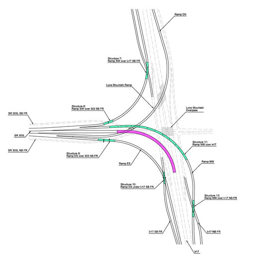
The Arizona Department of Transportation, in coordination with the Maricopa Association of Governments and the cities of Phoenix and Peoria, is improving Loop 303 between Lake Pleasant Parkway and Interstate 17 by adding an additional general purpose lane in each direction, bridges to accommodate a future interchange at 67th Avenue, and a new Loop 303/I-17 system-to-system interchange. The project seeks to address growing traffic demands on Loop 303.