I-10

ADOT takes a look back at 2011

ADOT takes a look back at 2011

SR24-1

ADOT takes a look back at 2011

ADOT takes a look back at 2011

January 3, 2012

2011's accomplishments include several projects.

The new year officially is here, but before we dive into 2012 we’re going to take a quick look back.

ADOT’s Public Information/Media Relations team came up with a great list of the state’s major transportation accomplishments from 2011 and we thought we’d share it here on the blog!

From new freeway openings to the approval of ADOT’s Long Range Transportation Plan, here's a look at some of the highlights …

Phoenix Area Freeways:

Loop 303 Opens

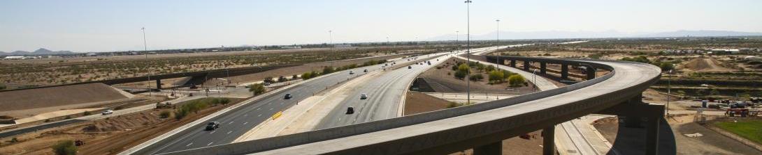
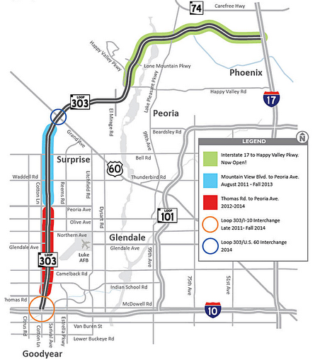
ADOT widened major stretches of Phoenix area freeways in 2011 and opened the first new segment of freeway to be built under the Maricopa Association of Government’s 20-year Regional Transportation Plan. Fourteen miles of Loop 303 were opened in May between Interstate 17 and Happy Valley Parkway in Peoria, allowing drivers for the first time to use Loop 303 to make the 39-mile trip between I-17 and I-10.

HOV Lane Additions

Drivers benefited from two accelerated projects to add High Occupancy Vehicle lanes along Loops 101 and 202. The final 30 miles of HOV lanes along Loop 101 between State Route 51 in north Phoenix and I-10 in Tolleson were opened in stages during the year and completed in November. Meanwhile, in the Chandler area, 12 miles of carpool lanes were completed this fall along Loop 202 Santan Freeway between I-10 and Gilbert Road.

I-10 Widening in West Valley

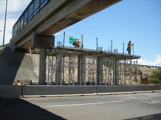
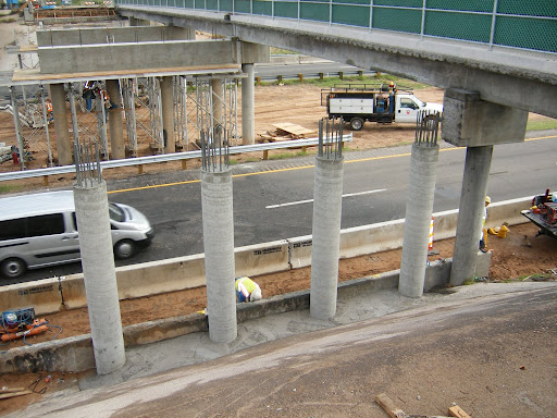
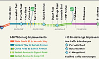
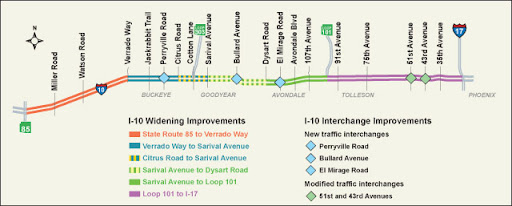
Another significant milestone was marked in August with the completion of ADOT’s three-year initiative to reconstruct and widen I-10 between Loop 101 and Verrado Way. Those projects modernized I-10, transforming what had been a limited highway with two lanes in each direction into a modern freeway that now provides as many as five lanes in each direction – including carpool lanes.

State Highway System:

Mescal Road/J-Six Ranch Road Bridge

Just over six months after a fiery crash damaged the Mescal Road/J-Six Ranch Road bridge, ADOT swiftly rebuilt the bridge to reconnect the Cochise County communities of Mescal and J-Six Ranch, which were separated by I-10 and depend on the overpass for convenient access to goods, services and neighbors. While the bridge was out of service, residents and workers in the Benson-area communities were required to take lengthy detours around I-10 to reach the other side of the highway. Federal Highway Administration emergency relief funds, a shortened time frame for designing the replacement bridge and a quick construction bid process all helped put the project on the fast track. A typical bridge construction project can take up to two years.

State Route 260 Widening

Continuing a decade-long commitment to expand the capacity of SR 260, ADOT completed a project to widen the highway starting 15 miles east of Payson from Little Green Valley to Thompson Draw. The $20 million project is the fourth of six projects to construct a four-lane divided highway from Star Valley to the top of the Mogollon Rim.

State Route 87 Improvements

ADOT fulfilled its commitment to complete SR 87 improvements before the Memorial Day weekend and in time for the busy tourism season in the Rim Country. The $11.8 million reconstruction and widening project included the addition of a third southbound lane to enhance safety and traffic flow along the uphill stretch during drives between Payson and the Phoenix area. The improvements were the latest in a series of projects during the last two decades to enhance travel on SR 87, which is now a divided four-lane highway between Mesa and Payson.

US 93 Widening Project

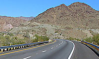
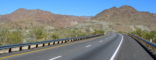
Shortly after ADOT completed a $71.3 million widening project on the US 93 approach to the new Hoover Dam bypass bridge in 2010, the first Desert Bighorn Sheep were spotted in February using one of the three wildlife crossings that were constructed to protect motorists and provide a safe crossing for the native animals. The project earned ADOT several honors this year, including the Arizona Chapter American Public Works Association Award, 2011 Public Works Project of the Year and FHWA’s 2011 Exemplary Ecosystem Initiative Award for the agency’s creative and innovative solution to balance motorists’ safety, while protecting wildlife and connecting ecosystems.

Hassayampa River Bridge Project

Just in time for the Fourth of July weekend, ADOT completed a $3.9 million bridge project over the Hassayampa River on I-10, approximately 40 miles west of downtown Phoenix. This area is a major route for travelers heading to and from California along I-10.

Overnight Bridge Demolition

On a late April night in southern Arizona, ADOT tore down two bridges in 10 hours – no small task. ADOT had already planned to remove the old Marsh Station bridge, which required a 67-mile overnight detour for motorists on I-10 east of Tucson. About three weeks before the demolition was set to occur, two semi trucks collided under the overpass at the Mescal Road/J-Six Ranch Road bridge. The bridge was badly damaged from the resulting fire and would have to be replaced.

Planning and Programming:

Long Range Transportation Plan

For more than two years, ADOT worked toward developing the state’s Long-Range Transportation Plan, a blueprint that looks 25 years into the future to determine how to plan for and fund transportation projects that keep up with Arizona’s needs. The State Transportation Board formally approved the Long Range Transportation Plan, also known as What Moves You Arizona, in November, allowing ADOT planners to move ahead with their work to develop a transportation system that will carry Arizona into the future. The award-winning program was nationally recognized for planning and involving the public.

Intercity Rail Study

In October, ADOT kicked off the public outreach phase of its intercity rail study. The study’s goal is to identify if there is a need for intercity rail along I-10 between Phoenix and Tucson. Over the course of a month, ADOT gathered information, data and comments. The agency will provide its findings to the public and to policymakers, so they can make an informed decision about how to move forward. ADOT is looking at all options, which include rail, transit—and the option to build nothing at all. The study will be complete in 2013.

Bicycle Safety Action Plan

As part of our public safety plan, ADOT is developing a Bicycle Safety Action Plan to help keep cyclists safe on Arizona’s highways. The goal is to reduce the number of bicycle crashes with motor vehicles and improve safety for both cyclists and drivers.  The goal of the Bicycle Safety Action Plan is to reduce the total number of bicycle crashes on Arizona highways by 12 percent by 2018.

Safe Routes to School

This year, nearly $3.5 million in grant funding was distributed by ADOT for 21 Safe Routes to School projects for schools and communities statewide. Eight of these projects, totaling $2.8 million, were designated for infrastructure improvements, such as the construction of sidewalks, crosswalks, bike lanes, signage and striping. An additional 13 projects, totaling $720,000, went toward non-infrastructure elements, such as providing bike helmets to students, safety education and law enforcement. All Safe Routes to School projects are designed to get kids walking or biking and adopt healthy habits.

Motor Vehicle Division and Enforcement and Compliance Division:

Motor Vehicle Division

MVD continued to improve the quality of customer service at MVD offices by shortening the wait times for the more common motor vehicle and driver license transactions, while serving over 3.5 million customers at MVD’s 54 offices or satellite/specialized offices in 2011 The average wait time per transaction was approximately 19 minutes, compared to over 45 minutes just five years ago. Throughout the year, MVD also provided transaction assistance to returning soldiers with the U.S. Army Intelligence Command at Fort Huachuca in southern Arizona. ADOT also launched several new specialty license plates, including the long-awaited Arizona Centennial plate.

Enforcement and Compliance Division

ADOT officers conducted Operation Bullhead, joint-agency commercial vehicle enforcement operation in Mohave County at the request of Bullhead City officials. ADOT officers recovered stolen vehicles identified during inspections. The enforcement division also created a Single Trip Overweight International Border Permit program for produce transporters out of Mexico and assisted local law enforcement with scrap metal yard investigations.

Other Accomplishments:

Grand Canyon National Park Airport

In June, the Grand Canyon National Park Airport, owned and operated by ADOT, began daily 737 airline service from McCarran International Airport in Las Vegas. Travelers can now book a flight on Vision Airlines out of Las Vegas to the Grand Canyon. The new service is the first step in a larger vision to make it easier for all tourists to visit the canyon. The Transportation Security Administration was also stationed at the airport this year, making it easier for airline companies to fly into the airport, since they no longer have to provide their own passenger screening.

Overnight emergency repairs follow I-10 tanker collision

Overnight emergency repairs follow I-10 tanker collision

SR24-1

Overnight emergency repairs follow I-10 tanker collision

Overnight emergency repairs follow I-10 tanker collision

November 18, 2011

I-10 was closed most of the day and night last Wednesday after two tanker trucks collided near Chandler Boulevard south of downtown Phoenix.

For hours, many drivers could see the resulting column of black smoke. Even more people saw footage and photos of the collision’s aftermath on the news and online.

What most didn’t see was the effort it took to reopen the freeway less than 24 hours after the fatal crash, which not only snarled traffic during the morning rush hour, but also severely damaged the road.

Timeline

ADOT’s ALERT Team arrived on the scene shortly after the 8 a.m. crash. The crew worked with other agencies to close a portion of I-10, divert traffic and create a safe location for all the emergency responders.

Even once the fire was out, work to clear the wreckage couldn’t begin for several hours because of the extremely high level of fuel vapors in the air. Once the vapors dissipated (which, with very little wind, took close to four hours), two additional tankers were brought in to remove the fuel that remained in the burned tanker.

Once the Fire Department cleared the scene, the wreckage was cleared and work could begin on repairing the road’s surface.

It was determined that repaving the badly damaged area immediately was the best way to maintain a safe, drivable surface while avoiding a future closure of the heavily traveled Interstate. Late Wednesday afternoon, ADOT worked to line up the contractors and resources needed to accomplish the repair work.

“We didn’t want to leave bad pavement for tomorrow’s morning traffic to drive on,” says ALERT Commander Tom Donithan.

By about 8:00 Wednesday evening, the section of road was milled with a machine that basically pulverizes the damaged asphalt into an “almost powder,” according to Donithan in the video above.

Once the road was milled and the old asphalt was swept away, a new layer of asphalt was put down.

Not long after that, at about 2:30 a.m., striping trucks were able to re-stripe the road and westbound I-10 between Loop 202 and Chandler Boulevard reopened to traffic at approximately 4:30 a.m.

Improvements on the way to Tucson area I-10

Improvements on the way to Tucson area I-10

SR24-1

Improvements on the way to Tucson area I-10

Improvements on the way to Tucson area I-10

October 14, 2011

Construction got started earlier this fall on a project that’s designed to bring some big improvements for a stretch of Interstate-10 in the Tucson area.

The I-10 widening project from Ruthrauff Road to Prince Road will not only expand the freeway to four lanes in each direction, but will also reconstruct the Prince Road traffic interchange so the road will pass over the Union Pacific Railroad tracks and I-10. New landscaping and entrance and exit ramp improvements are also part of the plan.

Right now traffic delays at the Prince Road/I-10 intersection are a frequent occurrence ... that’s because more than 40 trains pass through each day. This often causes traffic to back up onto nearby I-10. (Union Pacific Railroad plans to double the tracks in the near future; so many more trains are expected to pass through the intersection in years to come.)

Tucson District Engineer Todd Emery says in the video above that the plans to lower I-10 and bring Prince Road over the railroad and freeway will help alleviate the daily traffic jams.

Here are some basics on what you should know for this first phase of the project (as of Oct. 3):

  • Full access to all area businesses will be maintained throughout construction.
  • Prince Road is closed west of I-10.
  • Riverpark Drive, La Cholla Boulevard and Business Center Drive just west of I-10 at Prince Road are closed; however easy access to businesses and organizations on the west side of I-10 is possible by exiting I-10 at the Camino Del Cerro/Ruthrauff Road traffic interchange and using the eastbound frontage road.
  • The I-10 frontage road south of Prince Road will be accessible during construction.
  • Both the nearby I-10 Miracle Mile and I-10 Camino DelCerro/Ruthrauff Road traffic interchanges will remain open throughout construction.

Construction is scheduled to last about 26 months, so stay tuned. We’ll keep you updated on what to expect during the next phase of construction, slated to begin in fall 2012.

(Re)-bridging the gap: Mescal/J-Six Bridge set to open

(Re)-bridging the gap: Mescal/J-Six Bridge set to open

SR24-1

(Re)-bridging the gap: Mescal/J-Six Bridge set to open

(Re)-bridging the gap: Mescal/J-Six Bridge set to open

September 19, 2011

It’s been just about six months, but today the residents of Mescal and J-Six Ranch got their bridge back and can finally say goodbye to one lengthy detour!

These two Cochise County communities had been linked together by an overpass that spanned Interstate-10. But back in March, two semi-trucks collided underneath that bridge and the resulting damage was so severe that the connection between Mescal and J-Six had to be closed for safety’s sake.

Fast-forward to today ... a brand new bridge is in place, ready to accommodate the motorists who have been forced to take the long way whenever they needed to drive between the two neighborhoods.

“For most motorists traveling I-10, this closure was an inconvenience,” says ADOT Director John Halikowski in the video above. “It meant they’d have to travel a little farther to stop for gas. But for the communities of Mescal and J-Six Ranch, the overpass closure created a heavy burden. You see, the bridge is the only road connecting Mescal and J-Six Ranch. Residents from both sides were cut off from the businesses and services they rely on.”

Normally a project like this would have taken up to two years to complete, but ADOT put this job on the fast track because of the hardship the closure caused to local residents (motorists were seeing about 14 miles added to their round trips just to get across the road, which really starts to add up after a while).

The accelerated project started with the demolition of the old, damaged bridge. ADOT was able to take advantage of a previously scheduled April 8 closure of I-10 for the demolition of the nearby Marsh Station Bridge and was able to take down the Mescal/J-Six Bridge the same night.

An expedited design timeline also helped speed things along. An abbreviated bid process that focused on contractors with a track record of building bridges under emergency circumstances kept things moving, too.

The project received $955,000 in emergency funds from the Federal Highway Administration and construction was able to get started right after Fourth of July weekend.

Work included the placement of 35 new concrete box girders atop the bridge piers. Outside support beams were also placed, but they featured attached, precast bridge barriers designed to help expedite the construction.

Amazingly, by Sept. 9, crews were already prepared to pour 150 cubic yards of concrete for the 216-foot-long bridge deck.

The concrete took 10 days to cure and you’d better believe crews didn’t let that time go to waste! They continued to work by filling gaps in the barrier wall between box girders and putting the finishing touches beneath the overpass.

The very final step taken before the bridge could open to the public included placing temporary markers along the lanes (permanent striping will be added to the roadway at a future date).

We’ve followed the progress of this project through videos and blog posts and now that the bridge is open, we hope you’ll take a look back at what it took to get here! As you can see in the video above, this bridge is important to the two communities it connects.

We at ADOT would like to thank all the residents, business operators, as well as Cochise County officials for their patience and support!

Note: This blog post was updated to reflect a revised open date for the bridge. It opened Monday afternoon, about 16 hours ahead of its Tuesday scheduled date.

A new look at memorable I-10 bridge demos

A new look at memorable I-10 bridge demos

SR24-1

A new look at memorable I-10 bridge demos

A new look at memorable I-10 bridge demos

August 19, 2011

Last week we gave you an update on how the new Mescal/J-Six bridge is coming along...

You might also remember that the night the damaged bridge was taken down, the old Marsh Station bridge was also demolished just a few miles away. It was a huge project that required completely shutting down I-10 for the night.

Check out the video above for a quick look at the work involved with tearing down two bridges in less than 10 hours.

Cleaning, maintenance all part of I-10 tunnel upkeep

Cleaning, maintenance all part of I-10 tunnel upkeep

SR24-1

Cleaning, maintenance all part of I-10 tunnel upkeep

Cleaning, maintenance all part of I-10 tunnel upkeep

August 18, 2011

With roughly 240,000 vehicles driving through it each day, the I-10 Deck Park Tunnel needs the night off every once in a while for a good, thorough scrub!

Just about every four months, the tunnel is closed to traffic in order to allow crews the chance to wash the walls, maintain the ventilation systems and check on the tunnel’s 3,700 light fixtures (about 150-200 light bulbs are changed out each quarter!).

Crews typically complete the cleaning over two nights. That means only one side of the tunnel needs to be closed each night … leaving the other direction open to traffic.

Cleaning the white tile walls not only gives the tunnel a fresh look, but it also helps brighten things up a bit.

“We’re washing the walls and keeping them clean so the light bounces off the wall onto the deck so it makes a better drive through,” says ADOT Highway Operations Supervisor Ed Walsh in the video above.

A little history …

For anyone fairly new to the Valley, it might be hard to believe that the Deck Park Tunnel represents part of Interstate-10’s “final mile.”

It was 21 years ago this month that the tunnel was completed, closing up the last remaining gap in the 2,460-mile-long interstate that stretches across the country.

The project was a big one because the path of this final mile was in between two historic Phoenix neighborhoods.

Designers came up with an innovative plan to limit the impacts on the communities. Builders dug out the freeway’s path, put in the 10-lane roadway and covered up the top of the road with a deck made out of 19 side-by-side bridges, created a tunnel and then built a 30-acre city park on top. The project took more than five years to finish and cost an estimated $700 million.

Repairs to damaged bridge set to finish by fall

Repairs to damaged bridge set to finish by fall

SR24-1

Repairs to damaged bridge set to finish by fall

Repairs to damaged bridge set to finish by fall

August 10, 2011

Crews put the finishing touches on the shoring that will support the pier cap on the newly reconstructed columns. The old columns were severely damaged by fire on March 15.

The new Mescal Road/J-Six interchange is taking shape!

The Cochise County bridge will soon reunite two communities that were unexpectedly disconnected after trucks collided beneath the old overpass in March.

After a fast-paced pre-construction process, work to rebuild the bridge began in early July. Just one month in, the hard-working crews from Vastco Inc. have constructed the bridge columns next to the eastbound lanes and erected shoring on those new columns to pour a new pier cap, and completed the pier caps atop the other columns that survived the fiery crash.

All this is in preparation for the setting of 35 new bridge girders, which are scheduled to make their appearance on the scene later this month!

pier-one-columns

Rebar that will tie into a new pier cap pokes skyward from four new columns next to the eastbound lanes of I-10 at the project to replace the overpass.

Folks driving past this project on I-10 can expect two overnight closures – with traffic exiting on one side of the project and re-entering the interstate on the other side – while those girders are put into place.

Before you know it, a new bridge will mark the return of the short drive residents of Mescal and J-Six Ranch have missed these past several months.

ADOT truly appreciates the support and patience of these communities and looks forward to celebrating the reopening of the Mescal-J-Six bridge this fall!

Work wraps up on I-10 (Papago Freeway) in West Valley

Work wraps up on I-10 (Papago Freeway) in West Valley

SR24-1

Work wraps up on I-10 (Papago Freeway) in West Valley

Work wraps up on I-10 (Papago Freeway) in West Valley

July 28, 2011

Improvements to the 13-mile section of I-10 started in 2008
and finished up earlier this month.

The wait is over!

After more than three years since work first started, West Valley motorists now have a new and improved drive on I-10 as it stretches through Buckeye, Goodyear, Avondale and Tolleson.

Construction was completed in a series of projects that were all part of the Maricopa Association of Governments’ Regional Transportation Plan. ADOT worked with MAG and local communities in finalizing funding for the work, part of which included American Recovery and Reinvestment Act (ARRA) of 2009 funds or federal stimulus funds.

Work to improve this 13-mile section of freeway began in February 2008 and just finished up earlier this month. The goal was to enhance safety and commute times while also making economic development accessible and appealing along the corridor.

Take a look at what was involved with the three I-10 widening projects …

I-10 widening between Loop 101 and Sarival Avenue: $81 million project included the addition of two new “left or inside” lanes in both directions – including High Occupancy Vehicle lanes. Work started in February 2008 and was completed in December 2009.

I-10 additional widening between Dysert Road and Sarival Avenue: $31 million project included adding new “right or outside” lanes plus widening bridges in this area. Work started in November 2009.

I-10 widening between Sarival Avenue and Verrado Way: $22 million stimulus-funded project included adding new third lanes in each direction. Work began in September 2009 and traffic is now using the new lanes.

Now that construction is done, I-10 will have increased freeway capacity, better traffic flow and improved access! 

Staying safe on the road

Staying safe on the road

SR24-1

Staying safe on the road

Staying safe on the road

May 27, 2011
Blog Default

Memorial Day weekend is here and if you’re headed out of town you probably have your travel plans all wrapped up by now.

Hopefully those plans already include some safety preparations … if not, here are a few things to think about before hitting the road!

  • Check out your vehicle’s condition before a trip. Inspect things like tire condition and pressure, oil and other fluid levels and inspect belts and hoses.
  • Pay attention while out on the road and expect the unexpected.
  • Get plenty of rest before traveling and take regular rest breaks.
  • Be patient and alert to changing road conditions … and buckle up!
  • If your vehicle breaks down or you need to change a flat tire, pull completely off the roadway. Be cautious in areas with taller grass or brush – hot vehicle components can spark a fire.
  • Don’t drive under the influence of alcohol or drugs (even prescription drugs can limit your ability to safely operate a motor vehicle).
  • Cell phones or satellite devices help in an emergency – make sure they are fully charged.
  • Obey the posted speed limit and check for changing speed limit conditions.
  • Signal in advance for lane changes and turning maneuvers.
  • Take plenty of food and water.
  • Slow down in areas known for high winds and dust storms and be prepared to exit the roadway if extreme weather conditions occur. Weather conditions can change and monsoon storms can arrive suddenly, creating dust-filled winds and cutting visibility along the highway up ahead.

It’s always a good idea to allow some extra travel time, too. Unscheduled closures due to crashes or other incidents, including wildfires, can affect highway travel. Existing work zones for highway improvement projects, even when work is not taking place over holiday weekends, can add time spent on the road.

A couple of existing highway work zones to be aware of – especially at the start and end of the Memorial Day weekend – are located along Interstate 10 at the Hassayampa River bridges 40 miles west of downtown Phoenix and at the Interstate 17 bridges at Munds Park 20 miles south of Flagstaff. The highways are narrowed to one lane in each direction at those locations.

One last thing … before your trip you can call 5-1-1 or log on to ADOT’s Traveler Information site at az511.gov to check on updated highway conditions around the state.

How to tear down two bridges in 10 hours or less

How to tear down two bridges in 10 hours or less

SR24-1

How to tear down two bridges in 10 hours or less

How to tear down two bridges in 10 hours or less

April 15, 2011

In just 10 hours this past weekend, two bridges in southern Arizona were demolished in order to make way for something new.

All it took was some good planning, plenty of patience from motorists, a few enormous machines, and a ton of work by crews on the sites.

A little bit of background …

In November of 2009, ADOT began work on the I-10 Marsh Station Traffic Interchange in Southern Arizona -- a $10 million American Recovery and Reinvestment Act project that includes the extension of Marsh Station Road, drainage improvements, and the construction of a new traffic interchange to accommodate commercial truck traffic.

As it stood, the old Marsh Station Bridge had a clearance of 15 feet -- too low for most commercial trucks to clear. To avoid the bridge, trucks taller than 15 feet have had to maneuver a winding, two-lane, 67-mile detour.

(Note: Not until a nearby Union Pacific Railroad bridge is removed later this year, will most trucks be free to ditch the detour and safely pass through the new traffic interchange.)

But first things first, the old Marsh Station Bridge needed to come down. The only way to secure the work site and ensure the safety of both ADOT crews and the travelling public, however, was to close Interstate-10...forcing all local and interstate traffic into that same 67-mile detour!

After a lot of planning -- being careful to avoid Spring Breaks and other heavy-travel holidays -- ADOT set a date (April 8) and made arrangements to bring down the bridge, clean up the debris, and reopen the interstate, all in a 10-hour, overnight window.

The unexpected...

About three weeks before the demolition was set to occur, on March 15, two semi trucks collided under the overpass at the Mescal Road/J-Six Ranch Road Bridge about eight miles down the road from the from the old Marsh Station Bridge. The bridge was badly damaged from the resulting fire and would have to be replaced.

The task...

Since the interstate was already going to be closed, was it possible to safely get another bridge down in the same 10-hour window? Sure it was, and here’s what it took…

Breakdown by the numbers:

250:
The approximate number of tons of dirt that went down on the roadway below the bridges to act as a cushion for what the crews tore down.

1,480,000:
The approximate number of pounds of concrete removed during the demolition of both bridges. If you need a way to visualize just how much heft 740 tons is, it’s equal to the weight of about 120 adult male African elephants.

112,000 and 232,000:
The approximate pounds of rebar (112,000) and steel (232,000) that were removed during the take down of both bridges.

6:
The number of excavators used on both projects. Two excavators with scissor-like attachments worked on the Marsh Station Bridge demolition. Four excavators (two with the scissor-like attachments and two with hydraulic hammers) worked to bring down the Mescal Road Bridge.

45:
The number of seconds it takes us to show the Marsh Station demolition in this time-lapse video!