From the time Interstate 10 arrived in Tucson in 1965, we've worked to make sure the freeway kept pace with Pima County’s growth.
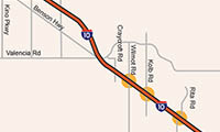
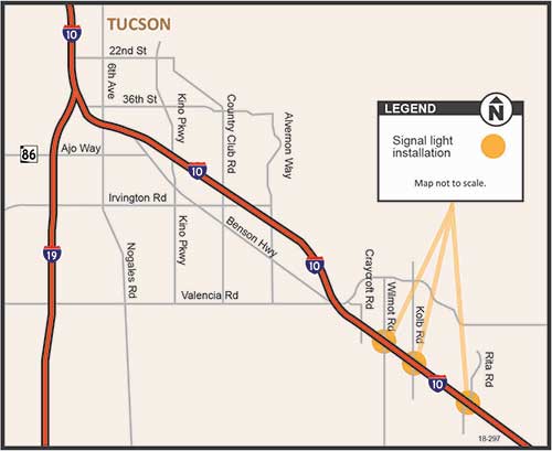
Growth in southeast Pima County is translating into more vehicles on I-10. Since 2012, average daily traffic on I-10 at Kolb Road has increased by nearly 20 percent to almost 50,000 vehicles each day.
That’s the reason behind the work we’ll be doing for the next seven months where I-10 meets Rita, Wilmot and Kolb roads. We’re replacing stop signs at the end of each exit ramp with traffic signals that will move traffic more efficiently on and off the freeway and reduce delays when you’re trying to get home at the end of a workday. We’re also adding lanes on the eastbound exit and westbound on ramps at Rita Road.
That’s not all. Two years from now we will rebuild the traffic interchange at Houghton Road with a diverging diamond design. It’s safer and moves traffic more efficiently than traditional interchanges.
Right now we’re adding a new surface to the bridge at Wilmot Road to make it last for years to come, just as we did at Craycroft Road last year. We’re using a temporary bridge to maintain two lanes of traffic in each direction and avoid delays.
As this area of Pima County grows, we're right there with you.
Everybody likes an upgrade, right? And even though the Motor Vehicle Division continues to make it easier for our customers – you – to get things done with us online, there are those times when a visit to an MVD location is needed.
Sometimes, an office needs a facelift.
For the good folks in Tucson, an upgrade of MVD’s Regional Service Center – the largest MVD office in the Old Pueblo – was definitely in order, and MVD has delivered.
We took an office that was designed for a different era (think back to when MC Hammer still made hit music) and turned it into an efficient, open environment that serves 21st century customers.
We ripped out walls that interrupted foot traffic. We installed energy-efficient LED lights, expanded our vehicle road test and inspection areas, and modernized our infrastructure to accommodate the rapidly changing computer environment for our employees.
One thing we didn’t change was our ongoing commitment to improvement. The time it takes to get in and out of our urban offices statewide is below 30 minutes and often lower.
MVD’s vision is to get you out of line and safely on the road. At the Tucson Regional Service Center, our “facelift” made that a little bit easier.
Last call for comments on this phase of the Sonoran Corridor study
Last call for comments on this phase of the Sonoran Corridor study
July 11, 2017
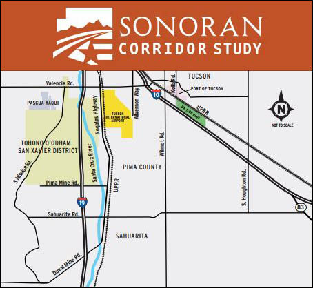
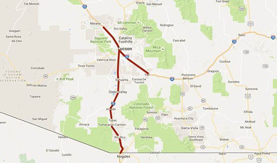
Sonorah Corridor Study Map
By Tom Herrmann / ADOT Communications
When Arizona Department of Transportation engineers met with the community in Tucson and Sahuarita a month ago to talk about the proposed Sonoran Corridor, a mid-July deadline to comment at the start of a three-year environmental study must have seemed far in the future.
Don’t look now, but that deadline will be here before the weekend.
As with any important project, you will have more chances during the three-year study to let us know what you think about the proposed Sonoran Corridor, which would connect Interstate 10 and Interstate 19 south of Tucson International Airport. But now is the time to make your feelings known if you want your input included during this initial scoping phase.
Our first step will be to study a range of possible corridors for their potential social, economic and environmental impacts. If there’s a route through the study area that you like or don’t like, this is the time to share that with us so we can take your input or concerns into account as part of our study. In about three years, we’ll likely come back to discuss a possible route in more detail.
Under the Fixing America’s Surface Transportation (FAST) Act, the Sonoran Corridor has been designated as high-priority route that would support the economy of southern Arizona and the entire state while, relieving congestion at the interchange of I-10 and I-19 in downtown Tucson.
We want to hear from you before the deadline of Friday, July 14. Here’s how:
Visit gg.mysocialpinpoint.com/sonorancorridor to select any part of the study area that’s important to you, drop a virtual pin onto it and leave your comments. This interactive tool is available in Spanish too.
Mail your comments to: Sonoran Corridor Tier 1 EIS Study Team, c/o ADOT Communications, 1655 W. Jackson St., Mail Drop 126F, Phoenix, AZ 85007 (must be postmarked by 5 p.m. Friday, July 15, 2017, to be included in the project record during the scoping phase).
There also is a toll-free bilingual information line: 855.712.8530.
We have no route, timetable or funding for the Sonoran Corridor so far. What we have is a chance for you to let us know your thoughts. For more information on the Sonoran Corridor, visit azdot.gov/SonoranCorridor.
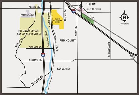
If you look closely, there seems to be something missing from the map of the Sonoran Corridor that accompanies this blog. Just south of Tucson International Airport, somewhere near where the map identifies PIMA COUNTY.
There’s a good reason for that: So far, it does not exist. No route. No timetable. No funding.
The Fixing America’s Surface Transportation (FAST) Act designated the Sonoran Corridor – a route that would connect Interstate 10 and Interstate 19 south of the airport as a high-priority corridor that would diversify, support and connect the economy of southern Arizona. It also would reduce congestion at the interchange of I-19 and I-10 and reduce travel distance in southern Arizona.
Twice this week – Wednesday in Tucson and Thursday in Sahuarita – ADOT and the Federal Highway Administration will welcome the public to scoping meetings on the project. We’re working to identify 2,000-foot wide corridors that could someday be the site of the route. Over about the next three years we will study the economic and environmental impact of building the Sonoran Corridor in those areas. We’ll also study the impact of not building a road.
This week’s meetings will be at Wednesday at the Radisson Hotel Tucson Airport (4550 S. Palo Verde Road) and Thursday at the Santa Cruz Valley United Methodist Church (70 E. Sahuarita Road, Sahuarita). Both meetings start at 5:30 p.m. with presentations beginning at 6 p.m.
There will be more chances to speak up on this project, but there may be no better time than while we’re just starting our environmental studies. We hope you’ll join us.
For more information on the Sonoran Corridor or to find other ways to comment, visit azdot.gov/SonoranCorridor.
Clearing the way for a better Ina/I-10 interchange
Clearing the way for a better Ina/I-10 interchange
March 2, 2017
By Caroline Carpenter / ADOT Communications
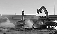
To make room for a modern traffic interchange at Ina Road and Interstate 10 in Marana, the old interchange must go. This ADOT video captured recent work to tear down the eastbound I-10 bridge.
Among other features that are on the way, the new Ina Road interchange will improve traffic flow and safety by creating a bridge carrying Ina Road over I-10 and the railroad tracks.
This $120 million project started last summer and is expected to wrap up in 2018. You also can download the town of Marana's Project Ina app to your smartphone to get information on and special offers from businesses along with traffic alerts.
From the Director: Pilot program starts for expanded truck loads on I-10, I-19
From the Director: Pilot program starts for expanded truck loads on I-10, I-19
September 7, 2016
Expanding Truck Load Map
By John Halikowski / ADOT Director
The Arizona Department of Transportation has started a year-long pilot program that allows slightly heavier trucks to travel on interstates in Southern Arizona. The program began Sept. 1.
ADOT is responding to requests from area leaders to help make commercial traffic more efficient. We chose Interstate 10 in the Tucson/Marana area and Interstate 19 between Tucson and Nogales including Business 19 because these roadways are Key Commerce Corridors, contributing significantly to Arizona’s economy and being near Mexico, the state’s top international trading partner.
Operating at the speed of business means that ADOT looks for ways to make freight travel as friction-free as possible while safeguarding Arizona’s investment in our highways and protecting public safety. As part of the pilot program, trucks may receive permits from ADOT that allows them to carry up to 83,000 pounds rather than the current weight limit of 80,000 pounds, making for a smoother transition between rail and highway modes for freight shipments. We will be studying whether the higher weight limit has an impact on the condition of our highways and on the safety of the traveling public.
This pilot program represents ADOT’s commitment to support Arizona’s businesses and export industries. We are a member of the I-10 Corridor Coalition (California, New Mexico and Texas) whose mission is to make travel on Interstate 10 safer and more efficient including freight movement. I look forward to sharing the data we collect with the three state departments of transportation.
This post originally appeared on ADOT Director John Halikowski's LinkedIn page. He has led the agency since 2009.
It was back in 2011 that we first told you about the improvements being made to I-10 and Prince Road in the Tucson area.
Today, nearly three years later, we’re happy to inform you of the project’s completion!
Since March, motorists traveling along Prince Road at the I-10 junction are no longer inconvenienced when one of the 40-60 trains pass daily through this area of Tucson.
Now, there’s no more waiting for the train to go by! Since ADOT opened the reconstructed Prince Road traffic interchange, motorists now are traveling over – instead of under – I-10.
The new overpass, which was built 30 feet above ground level on the east side of I-10 and slopes down to reach current ground-level, was a key part of a $76.4 million I-10 widening project between Ruthrauff and Prince roads. The project upgraded a two-plus mile section of I-10 by increasing capacity, reducing congestion and improving traffic flow on this highly traveled corridor in Tucson.
Over the past several months, work on the I-10 (Ruthrauff Road to Prince Road) widening project has been completed. Since March, crews have completed landscaping, electrical and barrier installation, sign installation and rubberized asphalt paving.
These improvements will help to increase the flow of traffic through the area and will also contribute toward increasing the safety of the traveling public.
If you’re interested in seeing this project’s progress, please revisit some of our previous posts.
But, before we take a look at the progress, let us first give you an overview of the project…
I-10 from Ruthrauff Road to Prince Road widening
ADOT started construction in September 2011 to widen I-10 between Ruthrauff and Prince roads in Tucson.
Besides widening that portion of I-10 to four lanes in each direction, the project also is set to reconstruct the Prince Road traffic interchange so that Prince Road will pass over the Union Pacific Railroad tracks and I-10 (this video gives a good explanation).
The project will also update the on- and off-ramps to provide better connections and access. New landscaping is part of the project, too.
Where things are now
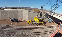
You can see in today’s video that crews recently worked to install 22 girders (each measuring in at about 120 feet) for the bridge over the Union Pacific Railroad. According to Resident Engineer Mindy Teague, the process is a little trickier than some of the other bridges on the project.
“We have to coordinate all of our actions with the trains coming through,” she says.
After the girders have been placed, the next step is to pour the bridge deck, says Tucson District Engineer Roderick Lane in the video.
“There’s kind of a big span between this bridge and the next bridge and that’s all going to be filled with dirt, so it’s really going to open up the whole west side of Prince Road for quite a bit of development opportunity,” Lane says, adding that ADOT has put a lot of effort into making business accessible during construction. “The light is at the end of the tunnel. We’re down to the last six months, or so. You can see everything coming up out of the ground and we really appreciate everybody’s patience and efforts as we move through this.”
Roadway restrictions are planned along I-10 and SR77 (Oracle Road) because of the El Tour de Tucson bicycle race. Drivers should allow extra travel time and consider alternate routes.
In addition, the University of Arizona football game home finale versus University of Oregon kicks off at 1:30 p.m. and significant traffic delays are expected. Football fans should leave early and consider using Kino Parkway or Park Avenue exits as alternate routes off of I-10 to Arizona Stadium.
Detours and road closures will be in place from 4 a.m. to 7 p.m. on Saturday, Nov. 23 for El Tour de Tucson: Eastbound I-10 frontage road from Tangerine Road to 22nd Street will be narrowed to one lane. Cyclists will be traveling in the right lane, except within the Prince Road construction project area, where they will be in the left lane briefly and then back into the right lane.
Construction DETOUR:
Due to the construction at Prince Road, vehicles will be detoured to the eastbound I-10 entrance ramp at Ruthrauff Road.
Drivers can take the Prince Road exit ramp to access the frontage road businesses or Business Center Drive.
Drivers leaving this area will be directed by law enforcement to use the right lane to allow cyclists to use the left lane.
Ramp restrictions will be in place on I-10 at Craycroft, Wilmot and Kolb roads. The eastbound I-10 exit ramp at Craycroft Road will be closed. The eastbound I-10 entrance and exit ramp at Wilmot Road will be closed. The eastbound I-10 exit ramp and westbound I-10 exit ramp at Kolb Road will be closed.
Northbound SR 77 from Ina Road to Rancho Vistoso Boulevard will be narrowed to two lanes. Cyclists will be traveling in the right lane and on the shoulder.
Westbound I-10 frontage road traffic will be detoured to eastbound 22nd Street. Eastbound 22nd Street will be restricted to one lane in each direction from I-10 to 4th Avenue. Cyclists will use westbound 22nd Street.
Eastbound I-10 exit ramps at Congress Road and 22nd Street/Star Pass Boulevard will be closed. The eastbound entrance ramps will remain open.
For the most current information about highway closures and restrictions statewide, visit ADOT's Travel Information site at az511.gov, follow us on Twitter (@ArizonaDOT) or call 511.
Construction got started earlier this fall on a project that’s designed to bring some big improvements for a stretch of Interstate-10 in the Tucson area.
The I-10 widening project from Ruthrauff Road to Prince Road will not only expand the freeway to four lanes in each direction, but will also reconstruct the Prince Road traffic interchange so the road will pass over the Union Pacific Railroad tracks and I-10. New landscaping and entrance and exit ramp improvements are also part of the plan.
Right now traffic delays at the Prince Road/I-10 intersection are a frequent occurrence ... that’s because more than 40 trains pass through each day. This often causes traffic to back up onto nearby I-10. (Union Pacific Railroad plans to double the tracks in the near future; so many more trains are expected to pass through the intersection in years to come.)
Tucson District Engineer Todd Emery says in the video above that the plans to lower I-10 and bring Prince Road over the railroad and freeway will help alleviate the daily traffic jams.
Here are some basics on what you should know for this first phase of the project (as of Oct. 3):
Full access to all area businesses will be maintained throughout construction.
Prince Road is closed west of I-10.
Riverpark Drive, La Cholla Boulevard and Business Center Drive just west of I-10 at Prince Road are closed; however easy access to businesses and organizations on the west side of I-10 is possible by exiting I-10 at the Camino Del Cerro/Ruthrauff Road traffic interchange and using the eastbound frontage road.
The I-10 frontage road south of Prince Road will be accessible during construction.
Both the nearby I-10 Miracle Mile and I-10 Camino DelCerro/Ruthrauff Road traffic interchanges will remain open throughout construction.
Construction is scheduled to last about 26 months, so stay tuned. We’ll keep you updated on what to expect during the next phase of construction, slated to begin in fall 2012.