Northwest

State Route 89 Yarnell Road Safety Assessment

State Route 89 Yarnell Road Safety Assessment

State Route 89 Yarnell Road Safety Assessment

State Route 89 Yarnell Road Safety Assessment

Overview

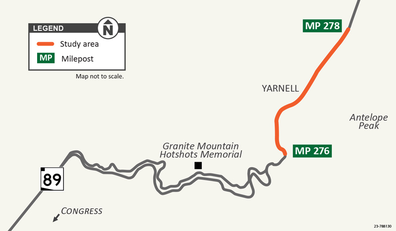
The Arizona Department of Transportation recently completed a safety study on State Route 89 between mileposts 276 and 278 in the community of Yarnell. The road safety assessment (RSA) identified potential safety issues related to roadway traffic and evaluated possible ways to eliminate or mitigate safety concerns for both drivers and pedestrians. The final RSA report is complete and available to the public. 
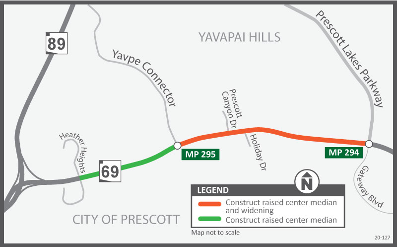
Project Area

SR 89 - Yarnell RSA Map


What the safety assessment found

ADOT’s RSA team, made up of a multidisciplinary team of traffic safety engineers and other specialists, analyzed past motor-vehicle crashes and current roadway use and configurations. 

The study of the two-mile section of SR 89 in the community of Yarnell had the following findings: 

  • A five-year crash history (2017-2021) of the two-mile stretch of SR 89 showed a total of 23 crashes with three injuries, two possible injuries and no fatalities. 
  • 16 of the 23 crashes were single-vehicle crashes. Less than half of the crashes were the result of a moving violation such as speeding or improper lane changes.
  • Pedestrians were observed crossing the street at various locations to get to various businesses or vehicles parked along the street. Some of the pedestrians used wheelchairs. 
  • Drivers regularly stopped in front of the Yarnell Post Office to drop off passengers and mail throughout the day. 
  • Some drivers were observed passing other vehicles in the four-lane section of the highway.
  • While visibility is good along this two-mile section, vehicles parked near street corners can impact the visibility of pedestrians waiting to cross the street.
  • Drivers traveling in the outside lanes are relatively close to the parked vehicles.


Community Traffic Safety Survey

In addition to analyzing past motor-vehicle crashes and current roadway use and configurations, the RSA team analyzed traffic and pedestrian safety concerns expressed by community members via a community survey administered by ADOT. The following is a summary of the survey results:

  • The top two community concerns are motorists driving faster than the posted speed limit and crossing the roadway as a pedestrian, bicyclist or wheelchair user.
  • Other concerns included challenges with drivers turning onto or from the highway, drivers passing other drivers and pedestrian visibility due to on-street parking. 
  • Regarding specific locations of concern, survey respondents identified the post office location as the #1 location for traffic safety.
  • When asked to provide comments for the RSA team to consider, increasing speed enforcement was the top comment, followed by installing crosswalks and new signage.


Recommendations of the study

Based on the findings of the RSA, ADOT recommends the following improvements:

  • One of the most significant countermeasures being recommended is to convert the four-lane section of SR 89 to a three-lane configuration. 
    • Restriping SR 89 from two lanes in each direction to one lane in each direction with a center left-turn lane will eliminate lane changes (passing) and reduce speed differentials between drivers.  
  • Installing pedestrian curb extensions and pedestrian refuge islands at two locations within the two-mile section. 
    • The curb extensions will significantly improve pedestrian crossings by reducing the pedestrian cross distance, improving the ability of pedestrians and drivers to see each other and reducing the time pedestrians are in the roadway.
    • The refuge islands will allow pedestrians to focus on crossing one direction of traffic at a time and give them a place to wait for an adequate gap in oncoming traffic before finishing the second phase of crossing the road.
  • Remove a limited number of parking spaces at street corners along SR 89 in order to improve visibility for both drivers and pedestrians waiting to cross the highway.

At this time, there is no funding in place to pay for any curb extensions and pedestrian islands recommended in the study.

The full Road Safety Assessment and the executive summary are available for review.

Initial project improvements have been completed as of September 2023.
 

Yarnell SR89 Safety Improvement Project Video

US 93: Moore Ranch Road to Milepost 190 Pavement Preservation Project

US 93: Moore Ranch Road to Milepost 190 Pavement Preservation Project

US 93: Moore Ranch Road to Milepost 190 Pavement Preservation Project

US 93: Moore Ranch Road to Milepost 190 Pavement Preservation Project

This project is complete

Overview

The Arizona Department of Transportation completed a project to remove and replace the existing top layer of pavement along US 93 between Moore Ranch Road and milepost 190 (mileposts 184-190) north of Wickenburg. The purpose of the project is to improve the condition of the pavement and extend its service life.

The $1.7 million project included the following:

  • Removing and replacing the friction course on northbound lanes.
  • Applying a fog coat pavement sealant to the southbound lanes.
  • Spot pavement repairs at mileposts 184 and 190. 
  • Reinstalling roadway striping and other pavement markings.

Project Area Map 

US 93: Moore Ranch Road to Milepost 190 Pavement Preservation Project


Stay Informed:

...


  • EmailSubscribe to receive project updates and traffic alerts.
  • Phone: ADOT Project Information Line: 855.712.8530.
  • Teléfono: Línea de Información del Proyecto ADOT: 855.712.8530
  • Online: Submit a question or comment through the ADOT website. Visit azdot.gov/Contact and then select Projects from the dropdown menu.
  • Twitter: Follow ADOT on Twitter  (@ArizonaDOT) for real-time highway conditions statewide.


US 93 Corridor Projects

US 93 Corridor Projects

US 93 Corridor Projects

US 93 Corridor Projects

Overview

ADOT has dedicated nearly half a billion dollars to widening and improving US 93 from Wickenburg to Hoover Dam over the last several years. ADOT's long-term vision is to transform this highly traveled route into a four-lane divided highway through the entire 200-mile stretch. The US 93 series of projects is a priority for ADOT and has significantly improved our state highway system to move people, goods and services more efficiently.

Current Projects

I-40/US 93 West Kingman Traffic Interchange

Construction on a new system-to-system traffic interchange started in July 2024. The project is scheduled to be completed in early 2027.

US 93 Cane Springs Improvements

Construction to widen a 4-mile segment north of Wikieup on US 93, mileposts 106 to 110, is scheduled to begin in January 2025. The project is scheduled to be completed in late 2026.

Current Studies

None

Completed Projects

US 93 Tegner St to Wickenburg Ranch Way (Dec 2024)

The Arizona Department of Transportation has initiated a construction project to widen and improve a 5-mile segment of US 93 between Tegner Street and Wickenburg Ranch Way (mileposts 194 - 199) in Wickenburg.  The project straddles two county lines, with about 70% located in Yavapai County and 30% in Maricopa County. 

Intersection of US 93 and Pierce Ferry Road (potential safety improvements)

Mohave County and the Arizona Department of Transportation have completed a feasibility study to evaluate potential safety improvements to the intersection of US 93 and Pierce Ferry Road. Learn more on the US 93 at Pierce Ferry Road Feasibility Study page.

Kingman to Hoover Dam (milepost 2 to 17)

In November 2010, ADOT completed construction on the final 15 miles of roadway south of the Hoover Dam, providing motorists with a continuous four-lane divided highway on Interstate 40 between Kingman and the new Hoover Dam Bridge.

Project construction included widening an existing 15-mile roadway section, and providing significant highway improvements. The $71.3 million lane widening project includes a new trailhead at milepost 4.1, and a new scenic overlook at milepost 13.5. The existing overlook (milepost 12.7) has also been upgraded. Three wildlife crossings over US 93 were constructed at mileposts 3.3, 5.2, and 12.2 to protect motorists and provide a safe crossing for the Desert Bighorn Sheep, native to the Black Mountains.

US 93, North of Wikieup (Carrow-Stephens road widening)

In December 2020, ADOT finished converting over three miles of US 93 north of Wikieup to a four-lane divided highway. This project connects two sections of highway that had already been widened. This provides a continuous stretch of divided four-lane highway from milepost 108, about 15 miles south of I-40, and milepost 121 near Wikieup.

The upgrade to a four-lane divided highway improves traffic flow, supports the movement of freight and enhances safety through this heavily traveled corridor. 
The majority of the 200-mile drive from Wickenburg to the Nevada state line has been widened. Fewer than 40 miles of US 93 remain a two-lane highway.

US 93 Pavement Preservation Project from State Route 89 to Rincon Road

The Arizona Department of Transportation completed work on a five-mile repaving project in May 2017,on US 93 between State Route 89 and Rincon Road (mileposts 193 to 198) in Wickenburg.

This $1.9 million project consisted of new rubberized asphalt, guardrail replacements, new striping and other miscellaneous work.

US 93 South of Interstate 40

The first segment on South US 93, spanning 36 miles between Wikieup and Santa Maria was completed in February 2008. This section of the highway was divided into 9 different projects. It included widening the highway to four lanes and building two bridges one at Burro Creek and the other at the Santa Maria River.

Southbound Wagon Bow Ranch and Southbound Deluge Wash

Construction to widen and improve a seven-mile segment of US 93 north of Wikieup (milepost 109 to 116.3) was completed in July 2012. The $26 million project provides motorists with new southbound lanes and another completed section of four-lane divided highway.

Wikieup to Interstate 40

ADOT has completed 4 widening projects between Wikieup and I-40. Construction on the Southbound Ranch Road project, located 17 miles north of Wikieup (milepost 104 to 106), was completed in late 2009. The $5.8 million lane widening project, funded by the American Recovery and Reinvestment Act, provides two additional miles of four-lane divided highway.

McGarry's Wash

Construction on US 93 at McGarry's Wash, located just south of the I-40/US 93 traffic interchange (milepost 91.7 to 95.2), was completed in October 2008. The $9.8 million project consisted of constructing a parallel roadway to create a four-lane divided highway.

Old US 93 to Antelope Wash

The $20 million four lane widening project from old US 93 to Antelope Wash (milepost 91.4 to 101.9) was completed in January 2007.

Tompkins Canyon

Construction north of Wikieup near Tompkins Canyon (mile post 119.5 to 121.2) consisted of parallel roadway to create a four-lane divided highway. The $10.6 million project was completed in November 2008.

US 93 Wickenburg Bypass

In February 2010, ADOT completed the Wickenburg Interim Bypass which has relieved the congestion at the intersection of US 93 and US 60 in downtown Wickenburg. The $30 million project included constructing a four-lane divided highway, two roundabouts and a new bridge.

Future Projects

Remaining highway improvement projects include

  • Gap Projects
  • US 93 Pavement Preservation: Sanctuary Road to I-40 (mileposts 48 to 71)
  • US 93 Pavement Preservation: E. Oldeup Road to 17 Mile Road (mileposts 131 to 144)
  • US 93 Big Jim Wash: Widen to 4-lane divided highway (mileposts 162 to 166)
  • US 93 Passing Lanes: Mileposts 172 to 173 and mileposts 176 to 177   

* Project schedules can change based on available funding and statewide priorities.

Restrictions and Closures

For information about project-related restrictions and closures please visit az511.gov or call 511, except while driving.

ADOT will provide more information about project schedules and potential traffic impacts as information becomes available.

Stay Informed!

...
  • By email: Subscribe to receive project updates and traffic alerts.
  • By phone: Nicole Underwood, ADOT Community Relations Project Manager: 480.601.1575 or ADOT Bilingual Project Information Line: 855.712.8530 
  • Online: Visit azdot.gov/contact and select Projects from the drop-down menu

State Route 89A: SR 89 - Glassford Hill Road Pavement Preservation Project

State Route 89A: SR 89 - Glassford Hill Road Pavement Preservation Project

State Route 89A: SR 89 - Glassford Hill Road Pavement Preservation Project

State Route 89A: SR 89 - Glassford Hill Road Pavement Preservation Project

This project is complete


Overview

The Arizona Department of Transportation initiated and completed a $2.4 million project to remove and replace the existing top layer of pavement along State Route 89A between State Route 89 and Glassford Hill Road (mileposts 317-323) in Prescott and Prescott Valley.

The project includes the following work:

  • Removing and replacing the top layer of pavement on north- and southbound lanes.
  • Making pavement spot repairs.
  • Applying a fog-seal pavement treatment to roadway.
  • Restriping the roadway.

Construction started this summer and was completed late summer/early fall 2023.


What to Expect

While the project work is underway, motorists will encounter alternating lane restrictions. One lane of traffic in each direction will be maintained throughout construction. Drivers should plan for possible delays while the work is underway. 


Project Area Map

SR 89A-SR89 to Glassford Hill Road Pavement Preservation Project Map


Stay Informed

...
  • Email: Subscribe to receive project updates and traffic alerts.
  • Phone: ADOT Project Information Line: 855.712.8530.
  • Teléfono: Línea de Información del Proyecto ADOT: 855.712.8530
  • Online: Submit a question or comment through the ADOT website. Visit azdot.gov/Contact and then select Projects from the dropdown menu.
  • Twitter: Follow ADOT on Twitter  (@ArizonaDOT) for real-time highway conditions statewide.

State Route 89A: Glassford Hill Road to Coyote Springs Road Pavement Preservation Project

State Route 89A: Glassford Hill Road to Coyote Springs Road Pavement Preservation Project

State Route 89A: Glassford Hill Road to Coyote Springs Road Pavement Preservation Project

State Route 89A: Glassford Hill Road to Coyote Springs Road Pavement Preservation Project

This project is complete

Overview

Project Cost: $818,000

The Arizona Department of Transportation administered and completed a $818,000 project to remove and replace the existing top layer of pavement along State Route 89A from Glassford Hill Road to Coyote Springs Road (mileposts 322-325) in Prescott Valley.  The project was completed in fall 2023.

The project includes the following:

  • Remove and replace the top layer of pavement on north- and southbound lanes. 
  • Reinstall roadway striping and other pavement markings.

Project Area Map

Project Area Map

What to Expect

While the project work is underway, motorists will encounter alternating lane restrictions. One one lane of traffic will be maintained in each direction throughout construction. Drivers should plan for possible delays while the work is underway. 


Restrictions and Closures 

For information about project-related restrictions and closures, please visit az511.gov or call 511, except while driving.

ADOT will provide more information about project schedules and potential traffic impacts as information becomes available. Stay informed of traffic restrictions before they occur by subscribing to receive timely traffic alerts by email.

Schedules are subject to change on weather and other unforeseen factors.


Stay Informed

...

EmailSubscribe to receive project updates and traffic alerts.
Phone: ADOT Project Information Line: 855.712.8530.
Teléfono: Línea de Información del Proyecto ADOT: 855.712.8530
Online: Submit a question or comment through the ADOT website. Visit azdot.gov/Contact and then select Projects from the dropdown menu.
Twitter: Follow ADOT on Twitter  (@ArizonaDOT) for real-time highway conditions statewide.

SR 69: Prescott Lake Parkway to Heather Heights Improvement Project

SR 69: Prescott Lake Parkway to Heather Heights Improvement Project

SR 69: Prescott Lake Parkway to Heather Heights Improvement Project

SR 69: Prescott Lake Parkway to Heather Heights Improvement Project

Project Cost: $9.8 million

Overview

The Arizona Department of Transportation, in partnership with the Central Yavapai Metropolitan Planning Organization, has initiated a project to widen and improve State Route 69 in the city of Prescott. A portion of the project is also located on the Yavapai Indian Reservation. The project will construct one additional travel lane in each direction on SR 69 between Prescott Lakes Parkway and Frontier Village (mileposts 294-295) with a raised center median. In addition, a raised center median will be constructed between Yavpe Connector and Heather Heights.

The purpose of this project is to improve traffic safety and increase the capacity of the roadway.

The project has been awarded, awaiting construction. Construction is scheduled to begin early July 2024 and take approximately nine months to complete, with a potential winter shutdown pending weather conditions and construction schedule.

Improvements include: 

  • Constructing one additional travel lane in each direction on SR 69 between Prescott Lakes Parkway and Frontier Village (mileposts 294-295) with a raised center median.
  •  Constructing a raised center median will be constructed between Yavpe Connector and Heather Heights.
  • Constructing curb and gutter.
  • Installing new pipe culverts and storm drains.
  • Removing and installing a traffic signal.
  • Signing, striping and other related work.

Project Map

SR 89A-SR89 to Glassford Hill Road Pavement Preservation Project Map

Presentations  

  • Two virtual public meetings were held on Wednesday, May 12, 2021.


Traffic Alerts / Project Updates

Feb. 2025

Work continues to progress on the State Route 69 improvement project between Prescott Lakes Parkway and Heather Heights in Prescott. 

The project, which is being done in partnership with the Central Yavapai Metropolitan Planning Organization, is constructing one additional travel lane in each direction on SR 69 between Prescott Lakes Parkway and Frontier Village (mileposts 294-295) with a raised center median. In addition, a raised center median will be constructed between Yavpe Connector and Heather Heights. 

Since construction began last July, the $9.8 million project is on track to be completed this summer.. Crews have completed several elements during the first phase of the project, including:

  • Constructed outside curb and gutter between  Prescott Lakes Parkway and Frontier Village. 
  • Installed new pipe culverts and storm drains between Prescott Lakes Parkway and Yavpe.
  • Temporary striping and road widening to 3 lanes in each direction.
  • Other related work.

Phase 1 of the project was completed this week, and the project will enter phase 2 of construction starting mid-April. Work during phase 2 includes:

  • Constructing raised center medians and a road island between Prescott Lakes Parkway and Heather Heights (milepost 296).
  • Removing and installing a new traffic signal at Holiday Drive. 
  • Replacing the top asphalt between Prescott Lake Parkway and Yavpe Connector.
  • Reconstructing driveways,  applying final striping, installing new signage and various shoulder work. 

During the month of March, all six lanes of traffic will be open with no restrictions. Notices will be shared prior to work returning in April to provide updated work schedules and road restrictions. 


With a tentatively scheduled winter shutdown, construction is anticipated to be completed in fall 2025. For more information, please visit the project’s website.

__________________________________________________

ADOT will post information about lane restrictions or closures as it becomes available. If you would like to receive traffic alerts and other updates by email, please subscribe here.


Project flyer

SR 69 flyer
English | 


Stay Informed

...

ADOT welcomes your questions and comments. Please contact us in any of these ways:

  • Online: Submit a question or comment through the ADOT website. Visit azdot.gov/Contact and then select Projects from the dropdown menu.
  • Email: Subscribe to receive project updates and traffic alerts.
  • By phone: Call the ADOT Bilingual Project Information Line at 855.712.8530.
  • Teléfono: Línea de Información del Proyecto ADOT: 855.712.8530
  • By mail: Write to ADOT Community Relations, 1655 W. Jackson St., MD 126F, Phoenix, AZ 85007

Follow ADOT on Twitter  (@ArizonaDOT) for real-time highway conditions statewide.

I-40: Rancho Santa Fe Traffic Interchange

I-40: Rancho Santa Fe Traffic Interchange

I-40: Rancho Santa Fe Traffic Interchange

I-40: Rancho Santa Fe Traffic Interchange

The Arizona Department of Transportation, in coordination with the city of Kingman and the Federal Highway Administration, will begin construction in December 2024 of a new traffic interchange, the Rancho Santa Fe Traffic Interchange on Interstate 40 (Exit 57) in east Kingman.

The purpose of this project is to provide access and accommodate future traffic volumes generated in the rapidly-growing east Kingman area and to relieve congestion at the existing East Kingman interchange (Andy Devine Avenue/State Route 66, Exit 54). 

Project Flyer

Project Area Map

I-40: Rancho Santa Fe Project Map


Overview

  • Construct a new traffic interchange on I-40 at milepost 57.
  • Construct a four-lane street along Rancho Santa Fe Parkway, north of I-40, between I-40 and Santa Rosa Drive.
  • Construct a four-lane street along Rancho Santa Fe Parkway, south of I-40, between I-40 and Louise Avenue.This section will include bicycle lanes, sidewalks, curb and gutter and a raised center median.


City of Kingman

  • Construct a two-lane street along Rancho Santa Fe Parkway, north of I-40, between Grand Canyon Road and Industrial Boulevard, near the Kingman Municipal Airport.


What to expect during construction

  • Work will take place during daytime hours.
  • I-40 traffic will be detoured on the future Rancho Santa Fe interchange ramp alignment while crews construct the new bridges over Rancho Santa Fe. 
  • Two travel lanes on I-40 will remain open in each direction.
  • Motorists should be prepared for delays of up to 15 minutes.
  • The speed limit will be reduced in the work zones.


Schedule 

More information will be posted prior to the work.

Schedule subject to change based on weather or other unforeseen factors.


Restrictions and Closures

For information about project-related restrictions and closures please visit az511.gov or call 511, except while driving.

ADOT will provide more information about project schedules and potential traffic impacts as information becomes available. Stay informed of traffic restrictions before they occur by subscribing to traffic alerts for the project.  


Stay Informed

...

ADOT welcomes your questions and comments. Please contact us in any of these ways:

  • Online: Submit a question or comment through the ADOT website. Visit azdot.gov/Contact and then select Projects from the dropdown menu.
  • By phone: Call the ADOT Bilingual Project Information Line at 855.712.8530.
  • By mail: Write to ADOT Community Relations, 1655 W. Jackson St., MD 126F, Phoenix, AZ 85007


Interstate 40: East Seligman Bridge Decks Replacement

Interstate 40: East Seligman Bridge Decks Replacement

Interstate 40: East Seligman Bridge Decks Replacement

Interstate 40: East Seligman Bridge Decks Replacement

This project is complete

Overview

The Arizona Department of Transportation in conjunction with the Federal Highway Administration has completed a project that included  reconstructing and replacing the east- and westbound bridge decks on Interstate 40 at exit 123 near Seligman in Yavapai County.

The $6.1 million project included replacing the damaged elements of the bridges, performing other upgrades to increase the lifespan of the bridges and included the following:

  • Removing and replacing the deck portions of the two bridges
  • Removing and replacing approach and departure slabs
  • Removing and replacing guardrails as needed
  • Removing and replacing embankment curb as needed

Project Fact Sheet

project fact sheet

    Project Area Map

    Interstate 40: East Seligman Bridge Decks Replacement Map


    Stay Informed

    ...

    Email: Subscribe to receive project updates and traffic alerts.
    Phone: ADOT Project Information Line: 855.712.8530.
    Teléfono: Línea de Información del Proyecto ADOT: 855.712.8530
    Online: Submit a question or comment through the ADOT website. Visit azdot.gov/Contact and then select Projects from the dropdown menu.
    Twitter: Follow ADOT on Twitter  (@ArizonaDOT) for real-time highway conditions statewide.