Bridges Engineering and Construction

Leslie Creek bridge sits on the edge of the state and history

Leslie Creek bridge sits on the edge of the state and history

SR24-1

Leslie Creek bridge sits on the edge of the state and history

Leslie Creek bridge sits on the edge of the state and history

By Kathy Cline / ADOT Communications
February 19, 2021

Today, determining jurisdiction is pretty simple. ADOT oversees all state highways and freeways, with individual counties and municipalities taking care of the local infrastructure that falls inside their boundaries. But in the early days of transportation, such things were still being worked out.

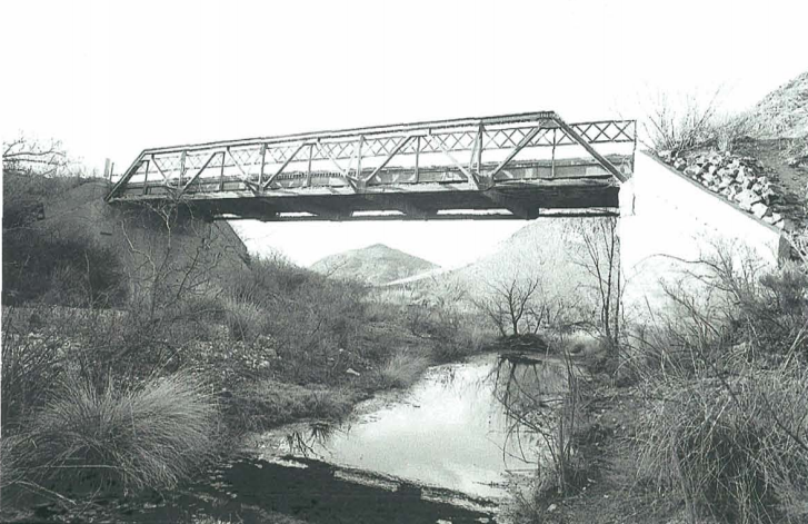
And that brings us to the Leslie Creek Bridge. Located along Leslie Canyon Road in Cochise County roughly 17 miles north of State Route 80 near Douglas, this bridge is going on 93 years and is listed on our inventory of historic bridges in the county

The origins of this 70-foot bridge goes back to 1928, when the Cochise County Board of Supervisors approved its construction. Chosen to make the parts that would eventually become the Leslie Creek Bridge was the Virginia Bridge & Iron Company, which made bridges across the country during this time. For this particular location, a truss comprised of 10 equal-length panels, with verticals at the panel points, was made. These fabricated parts were then shipped to Arizona via rail in May 1928. Construction got going almost immediatley using prison labor, which wasn't that uncommon at the time. The bridge was done by the end of that summer and has been functioning since. It was also a fairly common design for the times. In fact, the Leslie Creek Bridge is one of eight in the inventory with virtually the same structure. 

That's all well and good, you might say, but this is an ADOT blog, so why are we talking about a county bridge nowhere near a state highway?

Because the Leslie Creek Bridge was built at an unusual time. In the late 19th and early 20th centuries, local governments often took lead in establishing roads, bridges and other infrastructure. By the time the span over Leslie Creek was done, the Arizona Highway Department - the precursor to ADOT - had taken over the main responsibility for building bridges statewide. However, individual counties would still sometimes do smaller projects just as they always had. This particular bridge is one of the later examples of a county-built bridge, purchased in prefabricated parts from a national bridge company, and constructed by local crews.

And, hey, it seemed to work. Having a bridge just shy of a century is pretty impressive, no matter the size or where it's located!

Measuring slopes to prevent landslides

Measuring slopes to prevent landslides

SR24-1

Measuring slopes to prevent landslides

Measuring slopes to prevent landslides

By Laurie Merrill / ADOT Communications
February 16, 2021

Arizona’s mountainous terrain is as beautiful to look at as it is to drive through, but keeping dirt from those slopes off roadways can pose a technical challenge.  

That’s one reason the Arizona Department of Transportation has deployed highly sophisticated measuring equipment on embankments across the state.

On a recent trip to State Route 87 between mileposts 224 and 225 south of Payson, ADOT Geologist James Lemmon and Engineer-in-Training Ivan Bystov inspected two examples of this technology. The hill they're working on is part of a decade-old landslide known as the Sunflower Landslide.  

Lemmon and Bystov hiked along a ridge on the east side of the highway toward what looked like a yellow chimney sticking out of the hillside. In fact, the yellow riser is a steel casing to protect the inclinometer pipe and the piezometer equipment inside the well.  

The inclinometer enables scientists like Lemmon and Bystrov to measure the rate of slope movement over time.

“We are trying to see if there is a change or any instability,” said Lemmon, an ADOT Geotechnical Design Section-Bridge Group member.

The information is used to take preventive action if the hill is moving down a slope toward the roadway.  

“We know we must do something to buttress it to keep it from moving,” Lemmon said.

Lemmon said there are about 130 individual inclinometer wells installed at 30 embankment sites around the state. Sunflower Landslide has over 20 active inclinometers that are read on a regular basis. Some are on the roadway surface, many are on the near slopes and several are near the very top of the steep road cutouts and mountain slopes.

The piezometer measures moisture and saturation levels.

"When designing and constructing bridge foundations, we need to know the depth of where the saturated water level is under the surface so construction equipment doesn't sink and disappear into the saturated earth, Lemmon said. "And we design the foundation for a saturated groundwater situation. Those depths to water are measured by the piezometers."

The piezometer Lemmon and Bystrov displayed goes down about 60 feet deep, but Lemmon said there locations on the Sunflower Landslide where they go down nearly 400 feet deep.

ADOT geologist studies how to keep rocks from the highways

ADOT geologist studies how to keep rocks from the highways

SR24-1

ADOT geologist studies how to keep rocks from the highways

ADOT geologist studies how to keep rocks from the highways

By Laurie Merrill / ADOT Communications
January 22, 2021

If there's a list of experts on Arizona rocks, then ADOT Geologist James Lemmon's name has to be on it.

Like a detective, Lemmon studies the earth at sites before major projects are built. He also examines soil, rocks and moisture properties at the scenes of geologic hazards such as landslides and mudflows.

 “I investigate what earth materials are there and how they can be safely used in our transportation system,” said Lemmon, who works in the Arizona Department of Transportation Geotechnical Design Section-Bridge Group.

 “Whether we cut through them, build on top of them, use them to build up embankments, dig through them for deep bridge foundations, we look at the big picture.”

Nearly every road project has a geotechnical component requiring engineering and geology expertise, which is where Lemmon and the other professionals in his section come in.

“It’s part art, part science and engineering,” he said, which “comes with experience of spending time looking at a (site) and watching how it responds to the natural elements, like gravity and rain.”

Recently, Lemmon and engineer-in-training Ivan Bystrov stood atop what looks like a small mountain on State Route 87 at milepost 224. This is actually the Sunflower Landslide, the remains of an ancient landslide that reactivated - meaning it's no longer stable - after a hard rain about 14 years ago, Lemmon said. 

“Probably about a half of what I do is geologic hazards: landsides, rock falls, slumping roads, over-saturated ground. We go out and triage that,” Lemmon said. 

Water can wreak a lot of havoc on the dry Arizona landscape. Not only when it is part of a powerful storm that picks up rocks and creates landslides, but also when it destabilizes earth.  

One project in the works is removing the top of the Sunflower Landslide to reduce materials that could turn into a landslide, or some other type of hazard, during a powerful storm.  

“The goal is to slope it back, then drill in drainage to lower the soil moisture,” Lemmon said.

There are a number of projects in use along State Route 87, mostly aimed at protecting the road from the mountains through which it was built, including soil nail walls, landslide buttresses, mechanically stabilized earth walls along Slate Creek, pinned rock netting, gabion baskets, soil cement and grouted riprap on Slate Creek banks.

 Lemmon has always been fascinated by earth science. From an early age he collected rocks and was fascinated by fossils.

“In 7th grade I did a science project, ‘This is a Volcano,’ and I got to represent my little school in New Mexico at the science fair,” he said.

Lemmon turned that passion into a bachelor’s degree in environmental geology from Colorado Mesa University and then a master’s in geography from Arizona State University.

He joined ADOT in 2007 as an environmental planner, moving to the Geotechnical Design Section–Bridge Group in 2015. Prior to his time with the agency, he worked for the Arizona State Health Department in groundwater hydrology and then had his own environmental consulting company for 24 years.

But there’s more to Lemmon than rocks. He is passionate about both children and education and served as a Tempe Elementary School District No. 3 Governing Board member from January 2002 to December 2018. In fact, the Laird School named its library/technology center the James J. Lemmon Learning Commons, citing his positive impact and his role in rebuilding five of the district’s 21 schools.

“What an honor,” Lemmon said. “I got involved in the school district 20 years ago when I learned people were moving out of the neighborhood because of the schools.”

Curious as to why, he began solving problems at local schools and was successful in a number of energy reduction initiatives, custodial services redesign, numerous campus reconstructions, opening International Baccalaureate for Middle School and a Montessori school, and 13 years of pay raises for teachers and staff.

Lemmon also enjoys teaching the complexities of Arizona geology to others at ADOT. He loves earth science. And he loves his job. By keeping rocks off highways, he gets to make travel safer for Arizonans. 

As piers rise from below, Pinto Creek project at halfway point

As piers rise from below, Pinto Creek project at halfway point

SR24-1

As piers rise from below, Pinto Creek project at halfway point

As piers rise from below, Pinto Creek project at halfway point

By Garin Groff / ADOT Communications
August 12, 2020

A highrise of sorts is now standing within a few feet of US 60 where the Pinto Creek Bridge replacement project is underway east of Superior, but drivers passing through can be forgiven for overlooking it.

That’s because the towering structure is a 158-foot tall bridge pier rising from the bottom of a deep canyon, topping out roughly at the same level drivers pass through the area on the existing bridge.

The bridge pier is significant not just for its height, but also because its construction comes at what is roughly the halfway point of the $22.7 million bridge replacement project. This video gives a different perspective of how much progress ADOT is making, and you can really appreciate the height of the new piers as well as the existing bridge. If you still want more, we recently shared a fantastic slideshow showing what crews have been up to.

Once the three sets of bridge piers are complete in the coming months, crews will work into early 2021 to construct the bridge deck. That work will be a little more visible to drivers, as crews will work within about 30 feet of the existing bridge and at the same level as passing traffic.

Fortunately for drivers, ADOT will continue to minimize traffic impacts by keeping both lanes of travel open on US 60 in the project area during nearly all other stages of the project. 

Drivers can expect some restrictions when the concrete bridge deck is poured in early 2021. When the project nears completion next summer, US 60 will close for up to 5 days while crews realign the highway to the new structure. The existing bridge will be dismantled after traffic is shifted to the new structure.

For more information, please visit azdot.gov/PintoCreekBridge.

Everything now in place for the Fourth Street bridge project

Everything now in place for the Fourth Street bridge project

SR24-1

Everything now in place for the Fourth Street bridge project

Everything now in place for the Fourth Street bridge project

By Ryan Harding / ADOT Communications
August 5, 2020

Traffic is now driving on the new Fourth Street bridge, which opened recently after crews put the new bridges in place using an innovative method known as bridge sliding.

The bridge slide method is a technique that basically moves precast bridges using hydraulic jacks. The new Fourth Street bridges were moved nearly 50 feet into place after the old bridge was removed! This technique shaves a ton of time off of normal bridge construction. We’re talking days instead of months.

Fortunately for you, a member of ADOT’s video team was onsite to capture the Fourth Street bridge sliding into place. Check it out in this video to the right.

The new bridge is wider, adding a lane in each direction. It also includes a walled-off section for bicycles and pedestrians to cross the bridge, connecting the Flagstaff Urban Trail System across I-40.

The project as a whole is expected to wrap up this fall.

ADOT is always looking for new, innovative ways to deliver highway projects that can reduce delays and inconvenience for drivers. The bridge sliding technique is another way ADOT is delivering a safe, reliable transportation system more efficiently.

Throwback Thursday: A balanced approach

Throwback Thursday: A balanced approach

SR24-1

Throwback Thursday: A balanced approach

Throwback Thursday: A balanced approach

By David Rookhuyzen / ADOT Communications
July 30, 2020

We didn't have to search too far back to find this interesting shot of a bridge in the process of being built.

Drivers who travel between the Phoenix area and Payson may have no difficulty recognizing this as the State Route 87, known as the Beeline Highway. The photo comes from 1998 in the middle of a project to upgrade SR 87 to four-lane divided highway. The bridge that would eventually support the highway is being built using segemented construction. Basically, the bridge is built bit by bit with cast-in-place concrete segments that are added on using a specialized casting machine. That's the big white rigging you see there.

You'll notice, however, that there is a second machine in background on the other side of the bridge being built. The same work is happening on that end in what is known as cantilevering. Basically, segements are being added out from the supporting pier on both sides either simultaneously or in alternating turns to keep the entire structure in balance. Eventually all segements are connected and you have one, long bridge to drive across. In this case, the photo appears to be of the Screwtail Bridge, just south of Sunflower, which wound up being an impressive 1,080 feet, spanning a 105-foot-deep canyon. 

This innovative method was needed because the terrain between Phoenix and Payson is pretty rugged, as reflected in some of the curves and grades of the road's original alignment. By building bridges this way, ADOT was able to straighten and flatten the roadway a bit while also widening it and making sure to steer clear of sensitive riparian areas and wildlife corridors. 

Watch the creative destruction happening on I-10 at Ruthrauff

Watch the creative destruction happening on I-10 at Ruthrauff

SR24-1

Watch the creative destruction happening on I-10 at Ruthrauff

Watch the creative destruction happening on I-10 at Ruthrauff

By Garin Groff / ADOT Communications
April 3, 2020

We’re building a safer and more efficient interchange at Interstate 10 and Ruthrauff Road, but that can’t happen until we demolish all the old stuff.

To show you what’s involved, we’re sharing this ADOT video of the recent work to dismantle the eastbound I-10 bridge over Ruthrauff Road/El Camino del Cerro. Watch as Dan Casmer, ADOT’s senior resident engineer on the project, explains why we’re lowering I-10 so a new bridge can carry Ruthrauff Road over the highway and the Union Pacific Railroad tracks.

The video also shows how crews are doing what seems like a ton of work, so to speak. But if you’re counting how much material crews are removing, they’re really doing 1,215 tons of work.

Here’s a quick look at much concrete and steel crews ripped apart while demolishing the bridge:

  • 1,090 tons of concrete
  • 85 tons of steel girders
  • 40 tons of steel rebar

One thing you won’t see in the video or if you drive through the area: Everything being trucked away.

Only the steel will leave the site, hauled off to be recycled. Most of the concrete will remain within the mile-long project area. It will be crushed and used as fill material.

The $129 million I-10/Ruthrauff Road project began in January and is scheduled for completion in late 2021.

With state highways essential to delivering goods and services, ADOT, its employees and its contractor partners are dedicated to delivering transportation improvement projects during the current public health situation. To learn more please visit azdot.gov/covid-19-resource-center.  

ADOT, Flagstaff starting bridge widening project over I-40

ADOT, Flagstaff starting bridge widening project over I-40

I-17 101 traffic interchange

ADOT, Flagstaff starting bridge widening project over I-40

ADOT, Flagstaff starting bridge widening project over I-40

March 30, 2020

PHOENIX – In partnership with Flagstaff, the Arizona Department of Transportation is starting a project this week to improve traffic flow and add capacity for bicycles and pedestrians where Fourth Street passes over Interstate 40.

The Fourth Street bridge, which is currently one lane in each direction, will be replaced with a wider bridge offering two lanes in each direction, a center turn lane and a protected path for bicycles and pedestrians on one side and a sidewalk on the other. 

ADOT will use an accelerated bridge construction technique that basically slides precast bridges into place to reduce the time needed to complete the improvement and minimize delays for residents of Flagstaff’s east side and I-40 drivers. 

In addition to the improvements at Fourth Street, this project includes a resurfaced bridge deck and repairs to the pavement approaches to the Butler Avenue bridges over I-40.

The work is scheduled to be complete by winter. 

Flagstaff is funding half of the cost of the project while also paying for project enhancements such as bridge aesthetics. The new bridge will also connect the Flagstaff Urban Trail System across the interstate. ADOT will be administering the project.

Drivers should be aware of restrictions while work occurs. Fourth Street will be narrowed to one lane overnight throughout the project, with flaggers directing traffic. Drivers on I-40 can expect single-lane closures in one direction at a time on nights and weekends throughout the project.

In midsummer, the project will require a 17-day full closure of Fourth Street over I-40 to remove the old bridge and slide the new bridges into place. There will also be a full closure of Fourth Street over two weekends during the project. ADOT will send notice in advance of these closures.

Excavation work is scheduled to begin Wednesday, April 1. Residents should expect construction-related noise around-the-clock at various times throughout the project.

For more information, visit azdot.gov/projects and click on North Central District.

Navajo Bridge: Making connections since 1929

Navajo Bridge: Making connections since 1929

SR24-1

Navajo Bridge: Making connections since 1929

Navajo Bridge: Making connections since 1929

By Laurie Merrill / ADOT Communications
January 10, 2020

It's been more than 90 years since crews completed the original Navajo Bridge, an arching, architecturally significant span that looms dramatically across Marble Canyon and provides a rare vehicle crossing of the Colorado River in a remote, rugged part of the Southwest.

On Jan. 12, 1929, the first traffic rumbled across what was then the world’s highest steel-arch bridge. While a grand opening celebration would wait until June, that day marked a pivotal moment in Arizona’s economic and transportation development. This milestone of engineering design carried travelers 467 feet above the river to connect the Arizona Strip with the rest of the state.

“As the only crossing of the Colorado River for some 600 miles, the Navajo Bridge has had a profound impact on the commerce and transportation of a rugged, remote and isolated part of Arizona,” designer Clayton Fraser is quoted as saying in the National Park Service’s “Historic American Engineering Record.”

“An extraordinarily dramatic span high over the Grand Canyon, the Navajo Bridge is Arizona’s most aesthetically and functionally successful example of civil engineering,” Fraser said.  

For half a century before that, travelers used Lees Ferry at the bottom of Marble Canyon several miles upstream from where the bridge was built. According to the Engineering Record, boat crossings began in 1873, and the ferry was the primary passage until the opening of the Navajo Bridge, which was first called the Grand Canyon Bridge.

Navajo Bridge under construction
Throughout construction of the 834-foot-long, 18-foot-wide span, the biggest challenge was the river itself, which, according to the Engineering Record, “cut through the road like a giant slash in the desert fabric.”   

Laborers toiled long hours from dizzying heights above the river. Crews drilled and graded rocky bluffs. Supplies were carried on precarious footing.

It was with little fanfare that the Arizona Highway Department, the former name of the Arizona Department of Transportation, opened the bridge on Jan. 12, 1929. A chill wind blew on the few laborers and engineers who gathered in acknowledgement.

A gala ribbon cutting was scheduled during balmier weather on June 14-15.

As quoted in Engineering Record, The Arizona Republican, as The Arizona Republic was named at that time, described the scene as follows:

“Under a typical Arizona cloudless sky, the heat tempered by a gentle, southern breeze, the Grand Canyon Bridge across the chasm of the mighty Colorado river was formally dedicated by four governors of neighboring states this afternoon in the presence of a crowd of more than 5,000 persons, representatives of least 20 states.

“As movie and other cameras clicked and with three other chief executives of as many states standing by, (then) Governor John C. Phillips clipped the purple and yellow ribbons which represented the breaking of an age-old barrier between the lands to the north and south of Colorado River.”

The structure still exists today, though it has been a pedestrian bridge since 1995, when a new vehicle bridge was built 150 feet downstream to handle heavier, wider vehicles of contemporary times. 

The 1995 bridge is, as progress would dictate, longer, higher and with an increased steel arch length than the original, among other signicant updates. But the biggest difference, as you can guess, is dollars and cents. It cost $390,000 to build the historic bridge, while the modern span cost $14.7 million.

We've done blog posts about the bridge before, including this before-and-after view and this explanation of how ginger ale played a part in the bridge's hstory. If you are interested, you can also find a more detailed history of this important structure from the primary resource used in this report, National Park Service’s “Historic American Engineering Record.” Also of interest is this more recent report from the National Park Service.